|
Modern Wayfinding
"The principles of wayfinding are simple; the practicalities are very complex.
--Nainoa Thompson
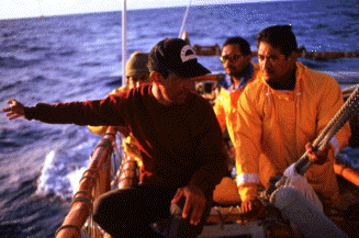
(Photo by M. Doi: Nainoa Thompson Training Some Cook Islanders in Non-Instrument Navigation)
 Wayfinding involves navigating on the open ocean without sextant, compass, clock, radio reports, or satellites reports. The wayfinder depends on observations of the stars, the sun, the ocean swells, and other signs of nature for clues to direction and location of a vessel at sea. Wayfinding was used for voyaging for thousands of years before the invention of European navigational instruments. In the 20th century, it is still practiced in some areas of Micronesia, although the traditional knowledge and techniques are in danger of being lost because of modernization and Westernization of the cultures of these areas. However, a revival of the art and science of wayfinding is underway among the Pacific islands, a revival led by Nainoa Thompson, the first modern-day Polynesian to learn and use wayfinding for long-distance, open-ocean voyaging. Thompson studied wayfinding under Mau Piailug, a master navigator from the island of Satawal in Micronesia. Mau navigated the first voyage of the Hokule'a to Tahiti in 1976; Thompson was Hokule'a's wayfinder on the 1980 and 1985-87 voyages. He is currently training 18 new navigators from Hawai'i and other Pacific islands. Wayfinding involves navigating on the open ocean without sextant, compass, clock, radio reports, or satellites reports. The wayfinder depends on observations of the stars, the sun, the ocean swells, and other signs of nature for clues to direction and location of a vessel at sea. Wayfinding was used for voyaging for thousands of years before the invention of European navigational instruments. In the 20th century, it is still practiced in some areas of Micronesia, although the traditional knowledge and techniques are in danger of being lost because of modernization and Westernization of the cultures of these areas. However, a revival of the art and science of wayfinding is underway among the Pacific islands, a revival led by Nainoa Thompson, the first modern-day Polynesian to learn and use wayfinding for long-distance, open-ocean voyaging. Thompson studied wayfinding under Mau Piailug, a master navigator from the island of Satawal in Micronesia. Mau navigated the first voyage of the Hokule'a to Tahiti in 1976; Thompson was Hokule'a's wayfinder on the 1980 and 1985-87 voyages. He is currently training 18 new navigators from Hawai'i and other Pacific islands.
A voyage undertaken using wayfinding has three components:
1. Setting up a course strategy, which includes a reference course for reaching the vicinity of one's destination, hopefully upwind, so that the canoe can make an easy downwind sail to the destination rather than having to tack into the wind to get there; (Tacking involves sailing back and forth as close as possible into the wind to make progress against the wind; it is very arduous and time-consuming, something to be avoided if at all possible. Psychologically and physically, it would be very difficult for the crew to face the most demanding part of the voyage at the very end.)
2. Trying to hold this course while keeping track of one's position in relationship to it during the voyage.
3. Finding land after reaching the vicinity of one's destination.
 Course Strategy and Departure Time Course Strategy and Departure Time
How the Wayfinder Holds the Canoe's Course
Compensating for Leeway in the Canoe's Heading
How the Wayfinder Calculates His Distance Made Good
Determining Position East or West of the Reference Course
How the Wayfinder Determines Latitude
How the Wayfinder Locates Land
How the Wayfinder Predicts Winds and Weather
Bibiliography - Wayfinding and Astronomy
|