 |
|
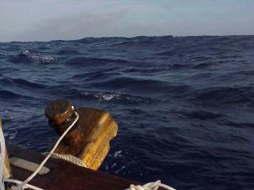
Wayfinding, or Non-Instrument Navigation Dennis Kawaharada (Photo below: Swells Help a Navigator Hold a Course in the Daytime) Introduction
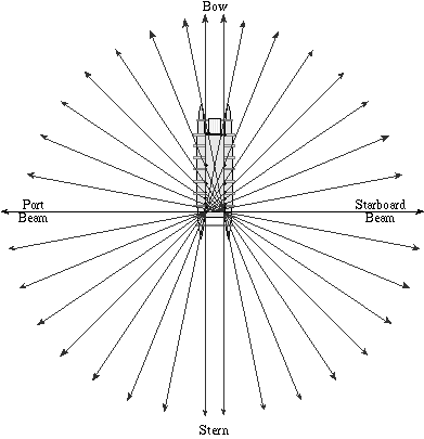
Navigator Nainoa Thompson of the Polynesian Voyaging Society, who was taught by Mau Piailug, a master navigator from Satawal in Micronesia, explains how a star compass is used to tell direction without instruments: "The star compass is the basic mental construct for navigation. We have Hawaiian names for the houses of the stars-the places where they come out of the ocean and go back into he ocean. If you can identify the stars, and if you have memorized where they come up and go down, you can find your direction. The star compass is also used to read the flight path of birds and the direction of waves. It does everything. It is a mental construct to help you memorize what you need to know to navigate. "How do we tell direction? We use the best clues that we have. We use the sun when it is low on the horizon. Mau has names for how wide and for the different colors of the sun path on the water. When the sun is low, the path is tight; when the sun is high it gets wider and wider. When the sun gets too high you cannot tell where it has risen. You have to use other clues. "Sunrise is the most important part of the day. At sunrise you start to look at the shape of the ocean-the character of the sea. You memorize where the wind is coming from. The wind generates the swells. You determine the direction of the swells, and when the sun gets too high, you steer by them. And then at sunset we repeat the observations. The sun goes down-you look at the shape of the waves. Did the wind change? Did the swell pattern change? At night we use the stars. We use about 220 stars by name-having memroized where they come up, where they go down. "When I came back from my first voyage as a student navigator from Tahiti to Hawaii the night before he went home, Mau took me into his bedroom and said "I am very proud of my student. You have done well for yourself and your people." He was very happy that he was going home. He said, "Everything you need to see is in the ocean but it will take you twenty more years to see it." That was after I had just sailed 7000 miles. "When it gets cloudy and you can't use the sun or the stars all you can do is rely on the ocean waves. That's why he said to me, "If you can read the ocean, you will never be lost." One of the problems is that when the sky gets black at night under heavy clouds you cannot see the swells. You cannot even see the bow of the canoe. And that is where people like Mau are so skilled. He can be inside the hull of the canoe and just feel the different swell patterns moving under the canoe and he can tell the canoe's direction lying down inside the hull of the canoe. I can't do that. I think that's what he learned when he was a child with his grandfather. "The Southern Cross is really important to us. It looks like a kite. These two stars in the Southem Cross always point south (Gacrux on top and Acrux on the bottom). If you are traveling in a canoe and going south, these southern stars are going to appear to be traveling the higher and higher in the sky each night. If you went down to the South Pole, these stars are going to be way overhead. If you are going north to Hawai'i, the Southern Cross travels across the sky in a lower and lower arc each night. When you are at the latitude of Hawai'i, the distance from the top star (Gacrux) to the bottom star (Acrux) is the same distance from that bottom star to the horizon. That only occurs in the latitude of Hawai'i.lf you are in Nuku Hiva at 9° S, the distance between the bottom star in the Southern Cross and the horizon is about nine times the distance between the two stars." The following techniques are used by Hawaiian and Polynesian navigators taught by Mau and Nainoa. The art, as it is practiced today in Hawai'i, uses a Hawaiian star compass developed by Nainoa, incorporating principles from Mau's Micronesian star compass and traditional Hawaiian names for directions and winds. The Sun The sun is the main guide for the navigator without instruments. Twice a day, at sunrise and sunset, it gives a directional point to the traveller, as it rises in the east and sets in the west. The exact direction changes during the year. As the earth, tilted at at 23.5° angle, orbits the sun, the sun appears to move in the sky against the background of the stars along a curving path called the ecliptic and through a series of 12 constellations called the zodiac. (See "The Ecliptic".) At the spring and fall equinoxes (Mar. 21 and Sept.23) the sun appears to be on the celestial equator and rises due east and sets due west. During the summer, the sun is north of the celestial equator, rising and setting north of east and west; at summer solstice (June 21), the sun rises 23.5° north of east ('Aina Ko'olau, or ENE) and sets 23.5° north of west ('Aina Ho'olua, or WNW). During the winter, the sun is south of the celestial equator, rising and setting south of east and west; at winter solstice (Dec. 22), the sun rises at 23.5° S of east ('Aina Malanai, or ESE), and sets 23.5° S of west in 'Aina Kona (WSW). Click here for a Diagram of the Rising and Setting Points of the Sun. To hold a course, the navigator aligns the rising or setting sun to marks on the railings of the canoe. There are 8 marks on each side of the canoe, each paired with a single point at the stern of the canoe, giving bearings in two directions, 32 bearings in all to match the 32 directional houses of the Hawaiian star compass. Click here for a Diagram of the 32 Bearings Marked onto the Canoe Rails. The Stars Like the sun, most stars rise in particular directions on the eastern horizon, travel across the sky, and set in particular directions on the western horizon. The directional house in which a star rises on the Hawaiian Star Compass has the same name as the house in which it sets (e,g., a star rising in 'Aina of the Ko'olau quadrant (ENE), sets in 'Aina of the Ho'olua quadrant (WNW). The directional point at which a star sets is at the same angular distance (delincation) and in the same direction (i.e., north or south) from west as the house in which it rose is from east. For example, at the equator, Hokulei (Capella) rises at 46° N of east in Manu Ko'olau (NE) and sets at 46° N of west in Manu Ho'olua (NW). Click Here for the Rising Points of the 21 Brightest Stars.) The navigator holds his course by orienting his canoe to these rising and setting points. For example, when the navigator with a favorable wind wants to head Manu Malanai (SE), and a star is rising at the point Manu Malanai (SE), he points the bow toward the star. If there is no star rising or setting in the direction he is heading, the navigator can orient the canoe using a star rising or setting anywhere else on the horizon, as long as he knows its direction. He keeps the star at a bearing that will head the canoe in the desired direction. Click here for a Diagram of Steering by the Stars. As wind drift may be carrying the canoe to the right or left of its apparent heading, the navigator corrects his steering for this sideway drift, called leeway ; as the night passes and stars rise and set, moving about 1 degree across the celestial sphere every four minutes, the navigtor uses as many stars as possible as clues to hold his direction. If the star is above the horizon, the navigator imagines a line from it down to its rising or setting point. The angles at which the stars rise and set will change with latitude. Only at the equator do stars appear to rise perpendicular to the horizon. In Hawai'i, at 20° N, stars rise and set at a 20° angle, leaning south from straight up; in Tahiti, at 17° south, stars rise and set at a 17° angle, leaning north from straight up. In other words, the angle at which stars rise and set from a line perpendicular to the horizon is equal to the latitude of the observer. The pathways of the stars lean south in the northern hemisphere and north in the southern hemisphere. As the navigator moves north or south of the equator, the rising and setting points will begin to shift north for stars north of east and west and south for stars south of east and west The shift will be smaller for stars near the celestial equator, and greater for stars toward the north and south celestial poles. (This shifting is due to the changing angle of the curved surface of the earth over which the observer sees the sky.) As the observer moves toward the poles, the angles of rising and setting of the stars will tilt closer and closer to the horizon until at the poles, the stars will not rise or set, but circle around the observer like figures on a merry-go-round, with the observer standing in the middle. At the north pole, only the northern half of the celestial sphere is visible; at the south pole, only the southern half of the celestial sphere is visible. A star which angles as it arcs through the sky is useful for determining direction when it is within 30-35 ° of the horizon; beyond this it becomes difficult to tell exactlywhere it rose or will set. At the equator, where stars rise perpendicular to the horizon, a star may be traced back to the horizon from a greater altitude. During a voyage, stars may be available for navigation only about 20 percent of the time; daylight and cloud-cover at night hide them from the navigator during the other 80 percent of the time. North and South Pointers Pairs of stars that cross the meridian at the same time are oriented north and south. (The meridian is an imaginary line from due north to due south passing through the zenith, the point in the sky directly overhead; the meridian is perpendicular to the horizon; stars move from east to west through the sky and cross the meridian at the midpoint of their journeys from horizon to horizon.) Meridian pairs, or pointers, in the northern sky point north; pairs in the southern sky stars point south. For example, the top and bottom stars in the Southern Cross, a meridian pair, point south when the Cross is upright. Meridian Pointers to the North Celestial Pole
Meridian Pointers to the South Celestial Pole
The Moon Like the sun, the moon travels along the path called the ecliptic; however, it completes it cycle in 29.5 days-the time it takes for the moon to orbit the earth. (See "The Moon Along the Ecliptic.") The moon rises about 48 minutes later each night at a different postion on the eastern horizon from where it rose the night before. Its rising point moves back and forth between 'Aina Ko'olau (ENE) and 'Aina Malanai (ESE) during its 29.5 day orbit around the earth; its setting point between 'Aina Ho'olua (WNW) and 'Aina Kona (WSW). As it changes its position in relationship to the sun and earth, it goes through 29-30 phases. The Hawaiian Lunar Month In the traditional Hawaiian calendar, the lunar month was determined by the 29.5-day cycles of mahina, the moon, and the passage of days were marked by the phases of the moon. The approximately 30 days of the moon cycle were divided into three 10-day periods (anahulu). The first 10-day period was called "ho'onui," "growing bigger."
The second 10-day period was called "poepoe," "round" or "full," when the moon appears full and round. The nights of the bright moon-possibly Akua, Hoku, and Mahe-a-lani- were referred to as "na po mahina konane"; konane means "bright moonlight."
The third 10-day period was called "'emi," "decreasing" or "waning." The moon begins to lose its light. The last quarter moon rises around midnight and sets around noon. Muku, the new moon, is unseen between the earth and the sun.
Determining the rising and setting points of the moon each night in relationship to another celestial body allows the moon to be used for navigation, day or night. The line separating light and dark on the moon's surface is aligned approximately north and south since the moon is positioned east or west of the sun as they travel across the sky. Hoku hele / "Traveling Stars" (Planets) Planets ("Wanderers") appear to move among the fixed stars over time; hence, their Hawaiian names hoku hele, "Traveling Stars", or hoku 'ae'a, "Wandering Stars." Their rising and setting points can be determined from nearby stars; they can be used for navigation once their positions have been determined. The Hawaiian names for the visible planets are:
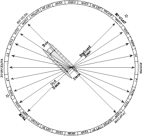
Ocean Swells During midday and on cloudy nights when celestial bodies are not available at the horzion as directional clues, the navigator uses the wind and swells to hold a course. However, the direction of wind and swells cannot be determined independently; their direction can only be determined by reference to celestial bodies such as the rising or setting sun. Swells are waves that have travelled beyond the wind systems or storms that have generated them, or waves that persist after the generating storm has died away. Swells are more regular and stable in their direction than waves. ("Waves," as opposed to "swells," are generated by local, contemporary winds.) Sometimes swells can be felt better than they can be seen, having flattened out after travelling long distances. In the Pacific, the northeast trade winds generate a northeast swell; the southeast tradewinds create a southeast swell, and so on. Storms in the South Pacific during the Hawaiian summer generate a south swell; storms in the north Pacific during the Hawaiian winter generate a north swell. Swells move in a straight line from one house on the star compass to a house of the same name on the opposite side of the horizon,180 ° away. Thus, a swell from the direction of Manu Ko'olau (NE) will pass under the canoe and head in the direction of Manu Kona (SE); a swell from 'Aina Malanai (ESE) will pass under the canoe and head in the direction of 'Aina Ho'olua (WNW). The navigator can orient the canoe to these swells. For example, if the canoe is heading SE Manu with a swell coming from the SE Manu, the person steering keeps the canoe headed directly into the swell, which lifts the bow, passes beneath, then lifts the stern. If the canoe is travelling SW, a SE swell would roll the canoe from side to side, lifting first the port hull, then the starboard hull as it passes beneath.(See "Steering by the Swells.") After the navigator orients the canoe to a swell pattern, he gets used to the pitching, rolling, or corkscrewing of the canoe; when the motion changes the navigator knows that the canoe is no longer going in the same direction (assuming the direction of the swell remains constant). The motion gets complex when more than one swell is running; an experienced traditional navigator like Mau can feel as many as four or five swells. Swells may change direction after a time because the storm generating them may be moving. In places such as the doldrums, the swell pattern can be confused by waves generated by variable local winds from isolated and passing squalls. When the seas are confused, navigation by ocean swells is difficult. Winds The direction of the wind can be used to hold a course-the person steering simply holds the wind at a constant bearing to the canoe. However, the wind may change directions during the day (it is less stable than swells), so the direction of the wind must be checked frequently against rising or setting celesital bodies and the ocean swells. (See "An Account of Tahitian Navigation".) Landmarks On coastal voyages, a navigator can steer by landmarks. Lining up two landmarks (e.g. a hill and a mountain) allows him to hold a straight line. Two pairs of landmarks allow him to find a spot, such as a deep-sea fishing ground, where the two lines intersect. One can also navigate by knowing the shape of reefs or underwater topography which can be seen from the surface. While leaving an island for the open ocean, the navigator backsights on the island, lining up two landmarks to hold his desired direction. Seamarks On the 1992 Hokule'a voyage from Hawai'i to Tahiti, Mau Piailug shared with navigator Shorty Bertelmann a seamark he had remembered from previous voyages along the route: Mau told Shorty to look for a school of porpoises; it would indicate that he had reached a point around 9 ° N latitude on the route to Tahiti. Bertelmann sighted the porpoises at around 9 ° N, confirming for him that he was on course and solidying his faith in the traditions of Pacific navigation. In Micronesia, these living seamarks are called "aimers"and are "purported to be associated with particular locales in the vicinity of islands or midway between them. They comprise such things as a tan shark making lazy movements, a ray with a red spot behind the eyes, a lone noisy bird, a swimming swordfish, and so on. Each of these phenomena has its own individual name and is located within a particular 'drag' on a particular star course from its associated island. on the long course from Puluwat to Eauripik there is said to be a row of whales, each situated a day's sail directly south of an island. Each whale has its own distinctive characteristic" (University of Pennsylvania). Grimble notes that Gilbert Island navigators also have a tradition of seamarks: "As Europeans use landmarks, so the Gilbertese [navigators] use seamarks to check their daily position. These signposts in mid-ocean consist of swarms of fish, flocks of birds, groups of driftwood, or conditions of wave and skypeculiar to certain zones of the sea. Hundreds of such traditional betia [seamarks] were stored up in the race memory as a result of cumulative experience of generations" (Grimble, Tungaru Traditions 48). These seamarks are found along routes between islands and indicate to the navigator that he was at a certain point along his route. For example, the seamark called "the swarming of beasts" consisted of an extraordinary number of sharks" and indicated the canoe was "a day's sail downwind of land." Other marks include a region where flying fish leaped in pairs, a zone of innumerable jellyfish, an area of numerous terns, an area of sharks and numerous red-tailed tropic birds, a place marked by a school of porpoises, a place where pairs of porpoises point their heads "in the direction of the passage into Tarawa lagoon" (Tungaru Traditions 49-50). Signs of Landfall Once the canoe is in the vicinity of its destination according to the navigator's dead reckoning and latitude measurements, the navigator starts looking for land. Navigating without instruments is not a precise science. Poor weather and mental lapses on a long voyage adversely affect its accuracy. But the navigator need not sail to a destination with pinpoint accuracy to be successful. Instead , the navigator in the Pacific tries to hit a "screen" of islands, that is, a group of islands that stretches out on either side of his destination. The longer or wider the screen, the less likely the navigator will miss it. Islands in the Pacific are seldom isolated; they are usually found in clusters. The Tuamotu Archipelago stretches 550 miles north to south and 500 miles east to west; the Society Islands stretches 160 miles north to south and 310 miles east to west; the Hawaiian islands extend more than a 1000 miles across the ocean east to west; the major islands form a north-south screen of about 240 miles. While sailing to Tahiti from Hawai'i, the navigator can target a 400-mile wide screen of islands between Manihi in the western Tuamotus, and Maupiti in the eastern Society Islands. If the navigator can hit any one of the islands in this target screen, he can reorient the canoe after he identifies the island and determines its position in relationship to his destination; if he does not recognize the island and the island is inhabited, he can ask the islanders where he is and if possible, get directions to his destination. While there are open-ocean gaps between islands in a screen, a navigator looks for signs to let him know the proximity and direction of land even when he cannot see it. Signs of land include drifting land vegetation; clouds piled up over islands; the loom above an island created by sunlight or moonlight reflecting up from the white sand and smooth water of a lagoon; distinctive patterns of swells created by swells refracting around and / or reflecting off islands; and seabirds. Land-Based Seabirds Seabirds such as the manu-o-Ku (white tern) and the noio (noddy tern) go out to sea in the morning to feed on fish and return to land at night to rest. The diurnal flights of such birds are the most useful signs for expanding landfall, since their flights to and from an island gives a fairly specific direction to the navigator. As the birds leave an island in the morning, the navigator can sail in the direction the birds are coming from to find land; as the birds rise up from fishing and return to an island in the late afternoon, the navigator can follow the birds to land. During nesting season, the habits of birds change. Nainoa Thompson tells this story about his first voyage to Tahiti in 1980-2400 miles navigated without instruments: "We saw two birds after the 29th day and I was extremely relieved. At least we were in the ball park. The birds rose up high and flew away, and we sailed in that direction; at night we couldn't see the island so we took the sails down and waited. The next morning, we looked for the birds to see what direction they were coming from and that would be the direction of the island. We waited for the first bird. All hands on deck. Not a single bird. I began to worry-it was my first voyage, and I was unsure of myself. Mau Piaulug was very calm and didn't say anything. We waited and we waited. The canoe was just sitting in the water, facing south. One of the canoe members was at the back of the canoe and a bird flies right over his head. The night before that we saw the birds flying south so how come late in the morning with the sun very high was this bird coming out of the north? That would suggest that we passed the island during the night. In my panic, I thought we had better start sailing back in that direction to find the island before the sun goes down again. We turned the canoe around. But when I started to sail north Mau, who has always said that his greatest honor would not be as a navigator but as a teacher, came to me and said, "No." It was the first time that he interrupted the trip. He said, "turn the canoe around and follow the bird." I was really puzzled. I didn't know why. He didn't tell me why. But we turned the canoe around and now we see other birds flying also. Mau said, "you wait one hour and you will find the island you are looking for." And after about an hour, Mau, who is about twenty years older than me-my eyes are physically much more powerful than his-he gets up on the rail of the canoe and says: "The island is right there." And we all stood up and we climbed the mast and everything and we just couldn't see it. Vision is not so much about what you do-but how you do it. It's experience. Mau had seen in the beak of the bird a little fish and he knew that the birds were nesting. They had flown out to sea before sunrise and were taking food back at mid-morning to feed their young, before they flew out to sea again to feed themselves." A low atoll with coconut trees can be seen at sea from about 7 -10 miles away; observing the daily flight patterns of seabirds can indicate the direction of islands far out of the range of sight. Thompson gives the following estimates of ranges of two seabirds that are the most reliable indicators of land:
Generally, sighting of large groups of birds are more reliable signs of islands than one or two birds stray birds or small groups. (See “Locating Land.”) |
 Before the invention of the compass, sextant and clocks, or more recently, the satellite-dependant Global Positioning System (GPS), Polynesians navigated open ocean voyages without instruments, through careful observation of natural signs. (
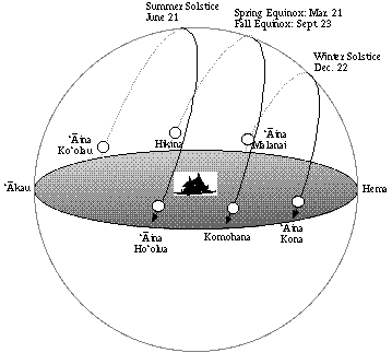