 |
|
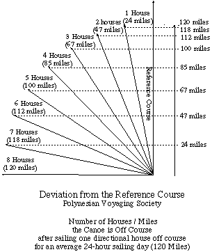
Determining Position East or West of the Reference Course The reference course which runs between the point of departure and the destination (see "Course Strategy and Departure Time") serves as a local 0 degree longitude line against which the wayfinder can keep track of his east-west position. During the voyage, the wind will either allow the canoe to sail along the reference course, or what is more likely, the wind will push the canoe off the reference course. Thus the canoe is either on the course line (0), or a certain number of miles to the east or west of it. When the wind pushes the canoe off the reference course, the wayfinder must keep track of how far off he is. Nainoa Thompson keeps track of deviation from the reference course in units called houses. If the canoe goes one sailing day in a direction one house to the west of the direction of the reference course, the canoe is one house to the west of the reference course; if, on the next day, the canoe goes one sailing day in a direction three houses to the east of the reference course, it would be two house to the east of the reference course. The houses east or west of the reference course are distances (not to be confused with directional houses) and can be translated into miles using a trigonometric formula for right triangles, given the distance of one leg (one sailing day = 120 miles) and one angle (one house = 11.25 degrees):
If the wayfinder loses track of his position in relationship to his reference course (e.g., during a prolonged storm or in prolonged cloudy conditions), he is lost; he can determine his north-south position (latitude) through observations of the stars, but he can't determine know how far east or west he is along that latitude. He remains lost until some landfall (or seamark) allows him to determine his location and reorient himself. When lost, the wayfinder can look for land by tacking back and forth across an area where he thinks his destination or some other island might be located. |
