Locating Land
Navigating without instruments is not a precise science. Poor weather and mental lapses on a long voyage adversely affect its accuracy. But the wayfinder need not sail to a destination with pinpoint accuracy to be successful. Instead , the wayfinder in the Pacific tries to hit a "screen" of islands, that is, a group of islands that stretches out on either side of his destination. The longer or wider the screen, the less likely the wayfinder will miss it. Islands in the Pacific are seldom isolated; they are usually found in clusters. The Tuamotu Archipelago stretches 550 miles north to south and 500 miles east to west; the Society Islands stretches 160 miles north to south and 310 miles east to west; the Hawaiian islands extend more than a 1000 miles across the ocean east to west; the major islands form a north-south screen of about 240 miles.
Thus while sailing to Tahiti from Hawai'i, the wayfinder can target a 400-mile wide screen of islands between Manihi in the western Tuamotus, and Maupiti in the eastern Society Islands. If the wayfinder can hit any one of the islands in this target screen, he can reorient the canoe after he identifies the island and determines its position in relationship to his destination; if he does not recognize the island and the island is inhabited, he can ask the islanders where he is and if possible, get directions to his destination.
Once the canoe is in the vicinity of its destination according to the wayfinder's dead reckoning and latitude measurements, the wayfinder starts looking for land.
An island at sea may be difficult to distinguish from a cloud at the horizon, particulary low coral islands known as atolls.
A high island, like the Big Island of Hawai'i, nearly three miles high, can be seen from 100 miles away. But to see an an atoll whose highest points are coconut trees, the wayfinder must be within around 7-10 miles.
The formula for seeing an object over the curvature of the earth is the following: "If a mountain peak is 'H' feet high and we are standing 'h' feet above the water, then we will first see the tip of the mountain on the horizon (in clear weather and calm seas) when we are 'D' nautical miles from the peak when you figure 'D' from the equation: D = (the square root of H) + (the square root of h)" (David Burch, Emergency Navigation, Camden: International Marine, 1986. 202-203).
For example, the highest point on Rapa Nui is Mt. Te Revaka at 1674 ft. The square root of 1674 is 41. On the deck of the canoe, a person stands about 9 feet above the water. The square root of 9 is 3. Thus he can see the tip of Te Revaka from a distance of 44 miles (41+3).
By climbing the mast of the canoe, the observer can increase his height above the water to 25 feet. The square root of 25 is 5, so he can see the tip of Te Revaka, under ideal conditions, from a distance of 46 miles.
Since there are open-ocean gaps between islands in a target screen, in order to avoid sailing through the screen without seeing anything, the wayfinder depends on techniques of "expanded landfall," looking for signs of land to tell him the proximity and direction of land even when he can't actually see it and thus expanding the presence of the island.
Signs of land include drifting land vegetation; clouds piled up over islands; the loom above an island created by sunlight or moonlight reflecting up from the white sand and smooth water of a lagoon; distinctive patterns of swells created by swells refracting around and / or reflecting off islands; and seabirds such as the manu-o-Ku (fairy tern) and the noio (noddy tern), which go out to sea in the morning to feed on fish and return to land at night to rest.
The diurnal flights of such birds are the most useful signs for expanding landfall, since their flights to and from an island gives a fairly specific direction to the wayfinder. As the birds leave an island in the morning, the wayfinder can sail in the direction the birds are coming from to find land; as the birds return to an island in the late afternoon, the wayfinder can follow the birds to land.
While a low atoll with coconut trees can be seen at sea from about 7 -10 miles away, observing the daily flight patterns of seabirds can indicate the direction of islands out of sight range. Nainoa Thompson gives the following estimates of ranges of two seabirds that are the most reliable indicators of land:
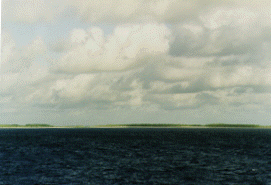
manu-o-Ku (white tern): approximately 120 miles (though this bird may stay out at sea, or fly back to land unseen at night)
White Tern. Photo by Monte Costa
noio (noddy tern): approximately 40 miles
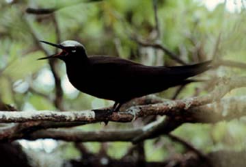
Noddy Tern. Photo by Monte Costa
During nesting season, the habits of birds change. Nainoa Thompson tells this story about his first voyage to Tahiti in 1980-2400 miles navigated without instruments:
We saw two birds after the 29th day and I was extremely relieved. At least we were in the ball park. The birds rose up high and flew away, and we sailed in that direction; at night we couldn't see the island so we took the sails down and waited. The next morning, we looked for the birds to see what direction they were coming from and that would be the direction of the island. We waited for the first bird. All hands on deck. Not a single bird. I began to worry-it was my first voyage, and I was unsure of myself. Mau Piaulug was very calm and didn't say anything. We waited and we waited. The canoe was just sitting in the water, facing south. One of the canoe members was at the back of the canoe and a bird flies right over his head. The night before that we saw the birds flying south so how come late in the morning with the sun very high was this bird coming out of the north? That would suggest that we passed the island during the night. In my panic, I thought we had better start sailing back in that direction to find the island before the sun goes down again. We turned the canoe around. But when I started to sail north Mau, who has always said that his greatest honor would not be as a navigator but as a teacher, came to me and said, "No." It was the first time that he interrupted the trip. He said, "turn the canoe around and follow the bird." I was really puzzled. I didn't know why. He didn't tell me why. But we turned the canoe around and now we see other birds flying also. Mau said, "you wait one hour and you will find the island you are looking for." And after about an hour, Mau, who is about twenty years older than me-my eyes are physically much more powerful than his-he gets up on the rail of the canoe and says: "The island is right there." And we all stood up and we climbed the mast and everything and we just couldn't see it. Vision is not so much about what you do-but how you do it. It's experience. Mau had seen in the beak of the bird a little fish and he knew that the birds were nesting. They had flown out to sea before sunrise and were taking food back at mid-morning to feed their young, before they flew out to sea again to feed themselves.
Generally, sighting of large groups of birds is a more reliable sign of a nearby island than sighting one or two stray birds or a small group:
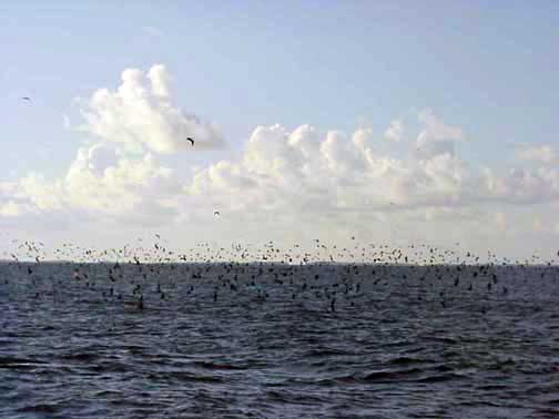
A large bird pile near Rangiroa Atoll in the Tuamotu Archipelago. Photo by Na‘alehu Anthony
Rangiroa is faintly visible at the horizon in the photo above. Hokule'a was looking for the Tuamotus on the way to Tahiti after having left Rapa Nui and finding Fatu Hiva in the Marquesas. Tahiti lies about 170 miles to the SW of Rangiroa. December 1999.
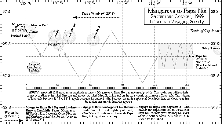
Search Strategy for Land
Should islands not appear where the navigator thinks they should be or an island is isolated and not in a target screen, the navigator can employ a search strategy that involves sailing in a zigzag pattern along a latitude determined from reading the stars.
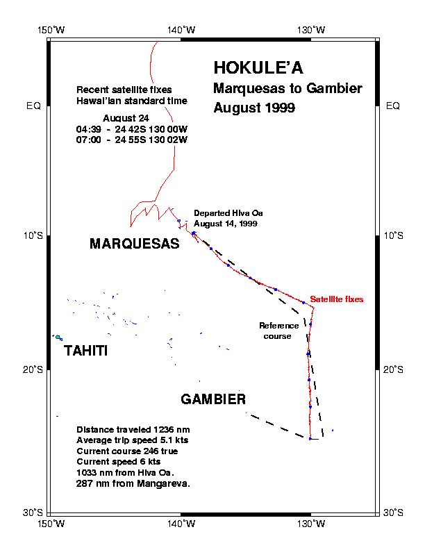
In the 1999, on a voyage from Hawai‘i to the Marquesas Islands, navigator Bruce Blankenfeld determined he was west of his target screen of the Marquesas Islands and searched backwards to the east, tacking along the latitude of 9 degrees south. He found the islands after a four day search.
During the voyage to Rapanui that year, the navigators designed a zigzagging search strategy to find that isolated island 1400 miles east of Mangareva.