
Holding a Course
How does a navigator determine direction and hold a course for his vessel, without navigational instruments?
Landmarks
On coastal voyages, a navigator can steer by landmarks along the coast. AS he heads away from land, he lines up two landmarks (e.g. a hill and a mountain) to hold a straight line. Two pairs of landmarks allow him to find a spot, such as a deep-sea fishing ground, where the two lines intersect. A navigator can also guide a vessel by the shape of reefs or underwater topography which can be seen below the surface.
A navigator heading out on a deep sea voyage backsights on the island, lining up two landmarks to hold his desired direction until they disappear at the horizon. Once on the open ocean, a flat surface of moving water, the navigator uses celestial bodies and ocean swells for direction. The sun and the moon rising and setting provide clues to direction. At night, stars rise at directional points on the eastern horizon and set at directional points in the west. (For an explanation of the the rising and setting of celestial bodies at specific points on the horizon, see “The Celestial Sphere.”)
Hawaiian Star Compass © Charles Nainoa Thompson
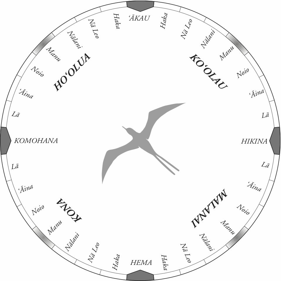
Star Compass ©, developed by Nainoa Thompson, loosely based on the Micronesian Star Compass of Mau Piailug. For pdfs of this compass and compasses with English and numerial equivalents, as well as Mau‘s star compass, see “Star Compasses.”
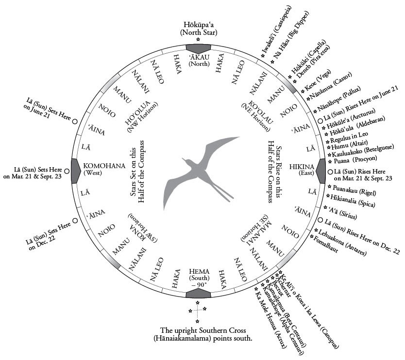
To help him orient the canoe to the rising and setting points of stars, Nainoa developd a star compass with thirty-two equidistant directional points around the horizon, each point 11.25° from the next point (11.25° x 32 points = 360°). Each point is the midpoint of a house of the same name, and each house is 11.25° wide (11.25° x 32 houses = 360°).
The four cardinal directions were giventraditional Hawaiian names:
East is called Hikina ("Arriving" or "Coming"), where the sun and stars "arrive" at the horizon;
West is called Komohana ("Entering"), where the sun and stars "enter" into the horizon;
North is called 'Akau ("Right," as one is facing west);
South is called Hema ("Left," as one is facing west).
The four cardinal directional points divide the circle of the horizon into four quadrants, which have been given names associated with winds that blow from that quadrant:
Ko'olau is the NE quadrant, named for the windward side of the islands, the direction from which the NE trades, the most constant of the Hawaiian winds, blow.
Malanai is the SE quadrant, named for "a gentle breeze" (PE) associated with Kailua O'ahu (SE part of the island) and Koloa, Kaua'i (S by E part of the island); on a wind map of Pukapuka, two "Malangai" winds blow from the SE.
Kona is the SW quadrant, named for the leeward side of the islands, away from the NE trades; winds blowing from the south or SW are called kona.
Ho'olua is the NW quadrant, named for a strong north wind, generated by storm systems passing north of the islands. (The Pukui-Elbert dictionary gives Kiu as the name of a northwesterly wind.)
Each quadrant contains seven directional points and houses with the following names:
La: "Sun"; the sun stays in this house for most of the year as it moves back and forth between its southern limit at the Tropic of Capricorn (23.5° S) at Winter Solstice to its northern limit at the Tropic of Cancer (23.5° N) at Summer Solstice.
'Aina: "Land"; This house between 17° and 28° on the horizon from east and west can be remembered because Hawai'i ('Aina, or Land) is at 21° N latitude and Tahiti ('Aina, or Land) is at 18° S latitude.
Noio: named for the Hawaiian tern, which helps a navigator find islands because it flies out to sea in the morning to fish (range about 40 miles) and returns to land at night to rest.
Manu: "Bird"; the four houses of Manu, midway between the four cardinal directions, can be seen as the points of the beak, tail, and outstretched wing-tips of a bird; the bird is the traditional Polynesian metaphor for the canoe. On early voyages to Tahiti, the Hokule'a sailed in the direction of Manu Malanai, with its wings and Manu Ko'olau and Manu Kona, and its tail pointed back at Manu Ho'olua.
Nalani: Named for the brightest star in this house, Ke ali'i o kona i ka lewa (Canopus), which rises in Nalani Malanai and sets in Nalani Kona.
Na Leo: "The Voices," referring to the voices of the stars speaking to the navigator.
Haka: "Empty"; named for the relatively empty skies around the north and south celestial poles; Kamakau say the names of these areas are Uliuli ("deep, dark blue") and Lipo ("deep, dark night").
(Information about the name of these houses is from Will Kyselka's Ocean in Mind 96-97).
Seven directional houses in each of the four quadrants combine to give 28 compass directions between the four cardinal points:
- La Ko'olau = E by N
- 'Aina Ko'olau = ENE
- Noio Ko'olau = NE by E
- Manu Ko'olau = NE
- Nalani Ko'olau = NE by N
- Na Leo Ko'olau = NNE
- Haka Ko'olau = N by E
- La Ho'olua = W by N
- 'Aina Ho'olua = WNW
- Noio Ho'olua = NW by W
- Manu Ho'olua = NW
- Nalani Ho'olua = NW by N
- Na Leo Ho'olua = NNW
- Haka Ho'olua = N by W
- La Malanai = E by S
- 'Aina Malanai = ESE
- Noio Malanai = SE by E
- Manu Malanai = SE
- Nalani Malanai = SE by S
- Na Leo Malanai = SSE
- Haka Malanai = S by E
- La Kona = W by S
- 'Aina Kona = WSW
- Noio Kona = SW by W
- Manu Kona = SW
- Nalani Kona = SW by S
- Na Leo Kona = SSW
- Haka Kona = S by W
Steering by the Sun
The sun is the main guide for the navigator without instruments. Twice a day, at sunrise and sunset, it gives a directional point to the voyager, as it rises in the east and sets in the west.
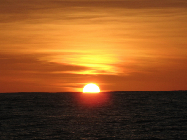
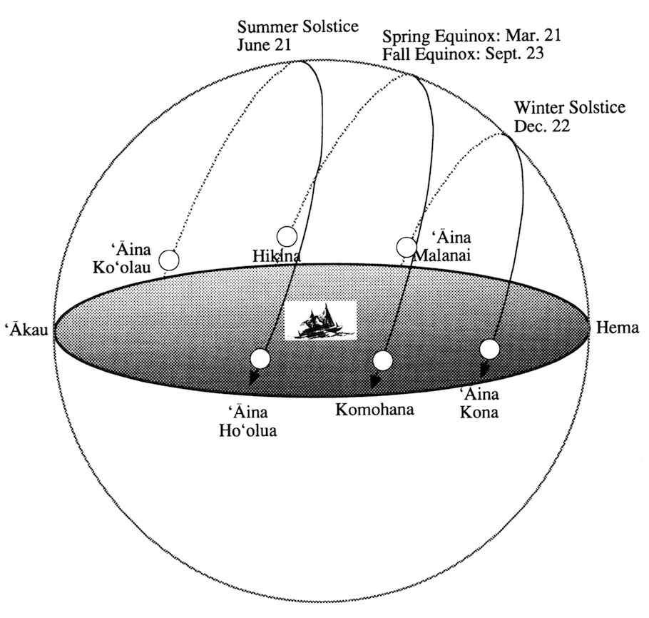
The exact direction changes during the year. At the spring and fall equinoxes (Mar. 21 and Sept.23), the sun rises due east and sets due west. During the summer, when the sun is north of the Celestial Equator, the sun rises and sets north of east and west; at summer solstice (June 21), the sun rises at ENE ('Aina Ko'olau) and sets at WNW ('Aina Ho'olua). During the winter, the sun is south of the celestial equator, rising and setting south of east and west. At winter solstice (Dec. 22), the sun rises at ESE ( 'Aina Malanai) and sets at WSW( 'Aina Kona). (See “The Celestial Sphere” – “How Earth's Orbiting the Sun Affects the Sun‘s Position on the Celestial Sphere” for an explanation of the changing rising and setting points of the sun.)
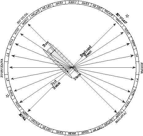
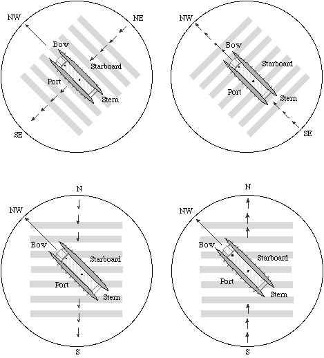
To hold a course, the navigator aligns the rising or setting sun to marks on the railings of the canoe. There are 8 marks on each side of the canoe, each paired with a single point at the stern of the canoe, where the navigator is stationed, giving 32 bearings to match the 32 directional houses of the Hawaiian star compass.
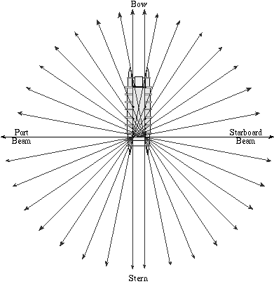
If the sun rises in the E and sets in the W, and he wants to head N, he holds the rising sun directly off the starboard beam and the setting sun directly off the port beam. If the sun is setting at WNW (two compass points north of W), and the navigator wants to head N, he holds the sun two bearings forward from the port beam.
Steering by the Stars
Like the sun, stars rise at the eastern horizon and set at the western horizon. If the navigator knows the directions in which stars rise and set, he can use the horizon as a compass.
For example, at the equator:
- Hokulei (Capella) rises NE (Manu Ko‘olau) and sets NW (Manu Ko‘olau).
- Hokule‘a (Arcturus) rises ENE (‘Aina Ko‘olau) and sets WNW ( ‘Aina Kona).
- A‘a (Sirius) rises near the border of E by S (La Malanai) and ESE (‘Aina Malanai) and sets near the border of W by S (La Kona) and WSW ('Aina Kona).
- Ke Ali‘i o Kona i ka Lewa (Canopus) rises SE by S (Nalani Malanai) and sets at SW by S (Nalani Kona).
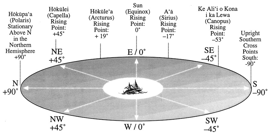
The numbers in degrees (°) (e.g. +19° or –17° are the stars declinations. The positive numbers indicate the stars rise and set north of E and W; the negative numbers indicated the stars rise and set south of E and W. (See “The Celestial Sphere” for an explanation of declination.)
Bright stars rising at night mark directional points along the eastern horizon:
The stars north of the Celestial Equator (e.g. north of the line from E and W, with positive declinations) will set in a house of the same name across from it, on the northwest side of the compass. Thus, at the equator, a star rising in Manu Ko‘olau (NE) would set in the direction of Manu Ho‘olua (NW).
The stars south of the Celestial Equator (e.g. south of a line from E and W, with negative declinations) will set in the house of the same name across from it, on the southwest side of the compass.
Bright Stars north of the Celestial Equator, with Positive Declinations
Star (Hawaiian / English Name) / Declination / House of Rising and Setting
- Hokupa'a / Polaris (The North Star) + 89° 'Akau
- Hokulei / Capella +46° Manu Ko'olau and Ho'olua
- Pira'etea / Deneb + 45° Manu Ko'olau and Ho'olua
- Keoe / Vega + 39° Noio Ko'olau and Ho'olua
- Nanahope / Pollux + 28° 'Aina Ko'olau and Ho'olua
- Makali'i / Pleiades + 24.5° 'Aina Ko'olau and Ho'olua
- Hokule'a / Arcturus + 19° 'Aina Ko'olauand Ho'olua
- Kapuahi / Aldebaran + 16° La Ko'olau and Ho'olua
- Regulus + 12° La Ko'olau and Ho'olua
- Humu / Altair + 9° La Ko'olau and Ho'olua
- Kauluakoko / Betelguese +7° La Ko'olau and Ho'olua
- Puana / Procyon + 5° La Ko'olau and Ho'olua
Bright Stars south of the Celestial Equator, with Negative Declinations
- Puanakau / Rigel - 8° La Malanai / Kona
- Hikianalia / Spica - 11° La Malanai / Kona
- 'A'a / Sirius - 17° La-'Aina Malanai Kona
- Lehuakona / Antares - 26° 'Aina Malanai Kona
- Fomalhaut - 29.5° Noio Malanai Kona
- Ke Ali'i o Kona i ka Lewa Canopus – 53° Nalani Malanai Kona
- Achernar - 57° Nalani Malanai Kona
- Beta Crucis / Becrux - 60° Nalani Malanai Kona
- Kamailemua / Beta Centauri - 60° Nalani Malanai Kona
- Kamailehope / Alpha Centauri – 61° Nalani Malanai Kona
- Ka Mole Honua / Acrux - 63° Na Leo Malanai Kona
As the observer moves away from the Equator, rising & setting points shift north for stars rising north of east; and south for stars rising south of east. At the north and south poles, stars travel in circles at fixed altitudes around the sky, without rising or setting. (See “The Celestial Sphere” for an explanation of these phenomena.)
When the navigator wants to head Manu Ko‘olau (NE) with the wind behind him and Hokulei (Capella) is rising at NE, he would point the canoe toward that star.
If there is no star rising or setting in the direction he is heading, the navigator will orient the canoe using a star rising or setting or to either side or at the back of the canoe, keeping the star at the bearing that will head the canoe in the desired direction. (The current and wind drift may be causing the canoe to drift to the right or left of his heading; see "Compensating for Leeway in the Canoe's Heading" in “Estimating Distance and Direction.”)
On a clear night, hundreds of stars will rise and set, and if the navigator recognizes them and knows the directions of their rising and setting, any of them will allow him to determine the direction in which he is going and to hold his course.
If a star, for example, Hokulei (Capella), rises in Manu Ko'olau (NE), and the navigator wants the canoe to head in the direction of Manu Ho‘olua (NW), he holds the rising Hokulei directly off the starboard beam. If he wants to head two directional points south of NW (i.e., WNW or ‘Aina Ho‘olua), he would steer the canoe so that Capella is two bearings to the back of the starboard beam.
Star rise at a rate of one degree into the sky every four minutes. In an hour, the star will be 15° above the horizon. At the horizon, the navigator can draw an imaginary line straight down to the horizon to get a directional point because the stars are rising and setting perpendicular to the horizon. As the navigator travels away from the equator, the angles at which the stars rise and set change. In Hawai'i, for example, at 20° N, stars rise and set at a 20° angle from perpendicular leaning south.
In Tahiti, at 17° S, stars rise and set at a 17° angle, leaning north from straight up. In other words, the angle at which stars rise and set from perpendicular is equal to the latitude of the observer; and the paths of stars lean south in the northern hemisphere and north in the southern hemisphere. (For an explanation of this angling, see “The Celestial Sphere.”)
Thus away from the equator, when the navigator draws an imaginary line from a star above the horizon, down to its rising or setting point on the horizon to get a directional point, the angle of rising and setting needs to be taken into account.
The best directional readings from stars are taken when the stars are near the horizon; the farther from the horizon the star rises, the more difficult it is to tell exactly where on the horizon it rose or is going to set.
At the equator, where stars rise perpendicular to the horizon, a star may be used up to 60° off the horizon. A star which angles as it arcs through the sky may be useful for determining direction until it is about 30-35° off the horizon. Any higher and it is difficult to pinpoint where it rose or will set.
The navigator must also be aware that the rising and setting points of stars on the horizon change with latitude. As the navigator moves north or south of the equator, the rising and setting points of the stars begin to shift north for stars north of the equator and south for stars south of the equator. The shift will be smaller for stars near the equator, and greater for stars toward the north and south poles. Thus, a celestial body that rises at NE by N and sets at NW by N at the equator, rises at NNE (rather than NE by N) and sets at NNW (rather than NW by N) at a higher latitude. (For an explanation of this shifting, see “The Celestial Sphere.”)
The stars are available about 20 percent of the time as clues to direction. Daylight and cloud-cover at night hide them from the navigator during the other 80 percent of the time.
To read the heavens at night, Nainoa Thompson identified four star lines made of the brightest, easiest to see stars. On clear nights, two of the lines can be used at any given time, one rising and one setting.
Directional Indicators for North and South
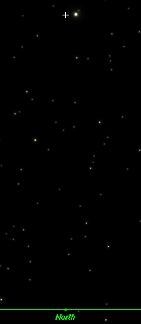
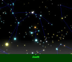
Hokupa‘a, the North Star is less than a degree away from the NCP , so when this star can be seen, the navigator can draw an imaginary line down to the horizon to find North. In the image below (the night sky in Honolulu at 21° N), Hokupa‘a appears about 21° above the horizon near the NCP (marked by the white cross). (The altitude of the NCP is equal to the latitude of the observer.) Hokupa‘a, circling the NCP, appears just to the right of it in this chart:
Pairs of stars that cross the meridian at the same time above the north or south horizon point down to North or South. (The meridian is an imaginary line from the NCP to the SCP, passing through the Zenith, the point in the sky directly overhead. The meridian is perpendicular to the horizon, and stars moving from east to west through the sky cross the meridian at the midpoint of their journeys from rising to setting.)
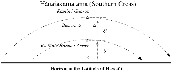
The navigator draws an imaginary line through the meridian pairs in the northern sky, and the line intersects the horizon at North; a line through the meridian pairs in the southern sky stars interesect the horizon at South. For example, the top and bottom stars in Hanaiakalama (the Southern Cross) are a meridian pair and point south when the Cross is upright crossing the meridian. The charts below depict Hanaiakalama as it crosses the meridian above due South in Hawai‘i:
See Meridian Pointers to North for charts of the following nine pairs of pointers:
Meridian Pointers to North
- Alpheratz in the Great Square of Pegasus paired with Polo'ula (Caph in Cassiopeia)
- Alpha Trianguli paired with Segin in Cassiopeia
- Theta Aurigae paired with Menkalinan, both in Auriga
- Puana (Procyon) paired with Nanamua (Castor) & Nanahope (Pollux)
- Hikulua (Merak) paired with Hikukahi (Dubhe) both in the Big Dipper
- Cor Caroli paired with Hikulima (Alioth in the Big Dipper)
- Ed Asich paired with Pherkad
- Gienah paired with Pira'etea (Deneb), both in Cygnus
- Markab paired with Scheat, both in the Great Square of Pegasus
See Meridian Pointers to South for charts of the following nine pairs of pointers:
Meridian Pointers to South
- Mirzim paired with Ke Ali'i o Kona i ka Lewa (Canopus)
- Suhail paired with a Star in the False Cross
- Cross Dividers: Mu Velorum paired with an Unnamed star cluster in Carina
- Hanaiakamalama (Southern Cross): Kaulia (Gacrux) paired with Ka Mole Honua (Acrux)
- Menkent in paired with Ka Mailemua (Beta Centauri), the first of the Pointers
- Alpha Lupi paired with Ka Mailehope (Alpha Centauri)
- Top stars in Kamakau (Scorpio): Dschubba paired with Ka Pi Scorpii
- Middle stars in Kamakau (Scorpio): Epsilon Scorpii paired with Mu2 Scorpii and Zeta Scorpii
- Bottom stars in Kamakau: Kamaka (Shaula) paired with Sargas
For meridian pointers used on the 1999-2000 voyage to Rapanui, see Voyage to Rapanui 1999-2000: Meridian Pairs.
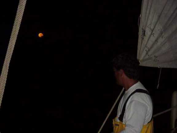
Steering by the Moon and Planets
The moon rises about 48 minutes later each night at a different postion on the eastern horizon from where it rose the night before. Its light waxes and wanes. (See The Hawaiian Lunar Month.)
Its rising point moves back and forth between 'Aina Ko'olau (ENE) and 'Aina Malanai (ESE); its setting point between 'Aina Ho'olua (WNW) and 'Aina Kona (WSW). (See “The Celestial Sphere” – “How Moon's Orbiting the Earth Affects the Moon's Position on the Celestial Sphere.”) Determining these points each night with the help of the rising and setting points of the fixed stars allows the moon to be used to hold a course during the night.
Also, the line separating light and dark in the moon points approximately north and south since the moon is positioned east or west of the sun as it arcs through the night sky.
Like the moon, the planets ("wanderers") appear to move among the fixed stars over time; hence, their Hawaiian names hoku hele, "Traveling Stars", or hoku 'ae'a, "Wandering Stars." Their rising and setting points can be determined from nearby stars, and they can be used for navigation once their positions have been determined. The Hawaiian names for the visible planets are:
- Mercury: Ukaliali'i ("Following the chief," i.e. the Sun)
- Venus: Hokuloa ("Long Star"), Hokuao ("Morning Star"), Hokuahiahi ("Evening Star"), Hokuali'i ("Chiefly Star"), Hokuali'iwahine ("Chiefly [female] Star")
- Mars: Hoku'ula ("Red Star"), Holoholopina'au, 'Aukelenuiaiku ("Great travelling swimmer, son of Iku")
- Saturn: Makulu ("A drop of mist")
- Jupiter: Aohoku ("Starlight"), 'Iao ("Dawn"), Ikaika ("Strong," "Powerful")
Steering by Ocean Swells
(Adapted from "Pitch and Roll" by Dave Lyman, in Polynesian Seafaring Heritage, Honolulu: Kamehameha Schools Press, 1980.)
When clouds hide the celestial signs, the navigator uses ocean swells to determine his direction. Technically speaking, swells are waves that have traveled beyond the wind systems or storms that have generated them, or waves that persist after the generating storm has died away. Swells are more regular and stable in their direction than waves. Ocean waves, as opposed to swells, are generated by local, contemporary winds.
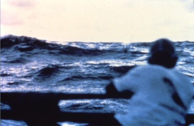
Reading Swells
Sometimes swells can be felt better than they can be seen, having flattened out after traveling long distances. In the Pacific, the northeast trade winds generate a northeast swell; the southeast tradewinds create a southeast swell. Storms in the south Pacific during the Hawaiian summer (winter in the Southern Hemisphere) generate a south swell. Storms in the north Pacific during the Hawaiian winter generate a north swell. The directions from which swells come from the horizon are determined by using celestial clues (the directions of the rising and setting sun and the stars).
Swells move in a straight line from one house on the star compass to another house of the same name in the opposite quadrant, 180° away. Thus, a swell from the direction of Manu Ko'olau (NE) will pass under the canoe and head in the direction of Manu Kona (SE); a swell from Manu Malanai (SW) will pass under the canoe and head in the direction of Manu Ho'olua (NW). The star compass, thus can also be used as a swell compass, to keep track of the movement of swells and correlate them to the rising and setting of stars.
The navigator can orient the canoe to these swells. If the canoe is heading SE Manu with a swell coming from the SE Manu, the steersman heads the canoe directly into the swell, the swell lifting the bow of the canoe first and pitching the canoe back, then passing beneath, lifting the stern of the canoe and pitching the canoe forward.
If the canoe is traveling SW, a SE swell would roll the canoe from side to side, lifting first the port hull, then the starboard hull as it passes beneath. If the canoe is heading south, the SE swell would hit the canoe at the port side at an angle of 45°, causing it to corkscrew, lifting the port bow first, then the starboard bow, then the port stern and finally the starboard stern.
After the navigator orients the canoe to the swell, he gets used to the pitching, rolling, or corkscrewing of the canoe; when the motion changes the navigator knows that the canoe is no longer going in the same direction (assuming the direction of the swells remain constant) and he reorients the canoe to get the motion right. The motion gets complex when more than one swell is running. An experienced navigator can feel as many as four or five swells.
A further complication is that the swells generated by storms may change direction after a time because the storm generating the swell is often moving. The navigator checks the directions of swells at least twice a day (sunrise and sunset). Also, in places such as the doldrums, the swell pattern can be confused by waves generated by variable local winds from isolated and passing squalls. When the seas become choppy and confused, navigation by ocean swells is difficult.
Steering by the Wind
The direction of the wind can be used to hold a course-the steersman simply holds the wind at a constant bearing on the canoe. However, the wind may change directions (it is less stable than swells), so the direction of the wind must be checked frequently against celestial clues.
Seamarks
On the 1992 Hokule'a voyage from Hawai'i to Tahiti, Mau Piailug shared with navigator Shorty Bertelmann a seamark he had remembered from previous voyages along the route: Mau told Shorty to look for a school of porpoises; it would indicate that he had reached a point around 9 ° N latitude on the route to Tahiti. Bertelmann sighted the porpoises at around 9 ° N, confirming for him that he was on course and solidying his faith in the traditions of Pacific navigation.
In Micronesia, these living seamarks are called "aimers" and are "purported to be associated with particular locales in the vicinity of islands or midway between them. They comprise such things as a tan shark making lazy movements, a ray with a red spot behind the eyes, a lone noisy bird, a swimming swordfish, and so on. Each of these phenomena has its own individual name and is located within a particular 'drag' on a particular star course from its associated island. on the long course from Puluwat to Eauripik there is said to be a row of whales, each situated a day's sail directly south of an island. Each whale has its own distinctive characteristic" (University of Pennsylvania website on Micronesian navigation; no longer available on the Internet).
Grimble notes that Gilbert Island navigators also have a tradition of seamarks:
As Europeans use landmarks, so the Gilbertese [navigators] use seamarks to check their daily position. These signposts in mid-ocean consist of swarms of fish, flocks of birds, groups of driftwood, or conditions of wave and sky peculiar to certain zones of the sea. Hundreds of such traditional betia [seamarks] were stored up in the race memory as a result of cumulative experience of generations. (Tungaru Traditions 48)
These seamarks are found along routes between islands and indicate to the navigator that he was at a certain point along his route. For example, the seamark called "the swarming of beasts" consisted of "an extraordinary number of sharks" and indicated the canoe was "a day's sail downwind of land." Other marks include a region where flying fish leaped in pairs, a zone of innumerable jellyfish, an area of numerous terns, an area of sharks and numerous red-tailed tropic birds, a place marked by a school of porpoises, a place where pairs of porpoises point their heads "in the direction of the passage into Tarawa lagoon" (Tungaru Traditions 49-50).