
On Wayfinding
Nainoa Thompson
The star compass is the basic mental construct for navigation. We have Hawaiian names for the houses of the stars – the place where they come out of the ocean and go back into the ocean. If you can identify the stars as they rise and set, and if you have memorized where they rise and set, you can find your direction.
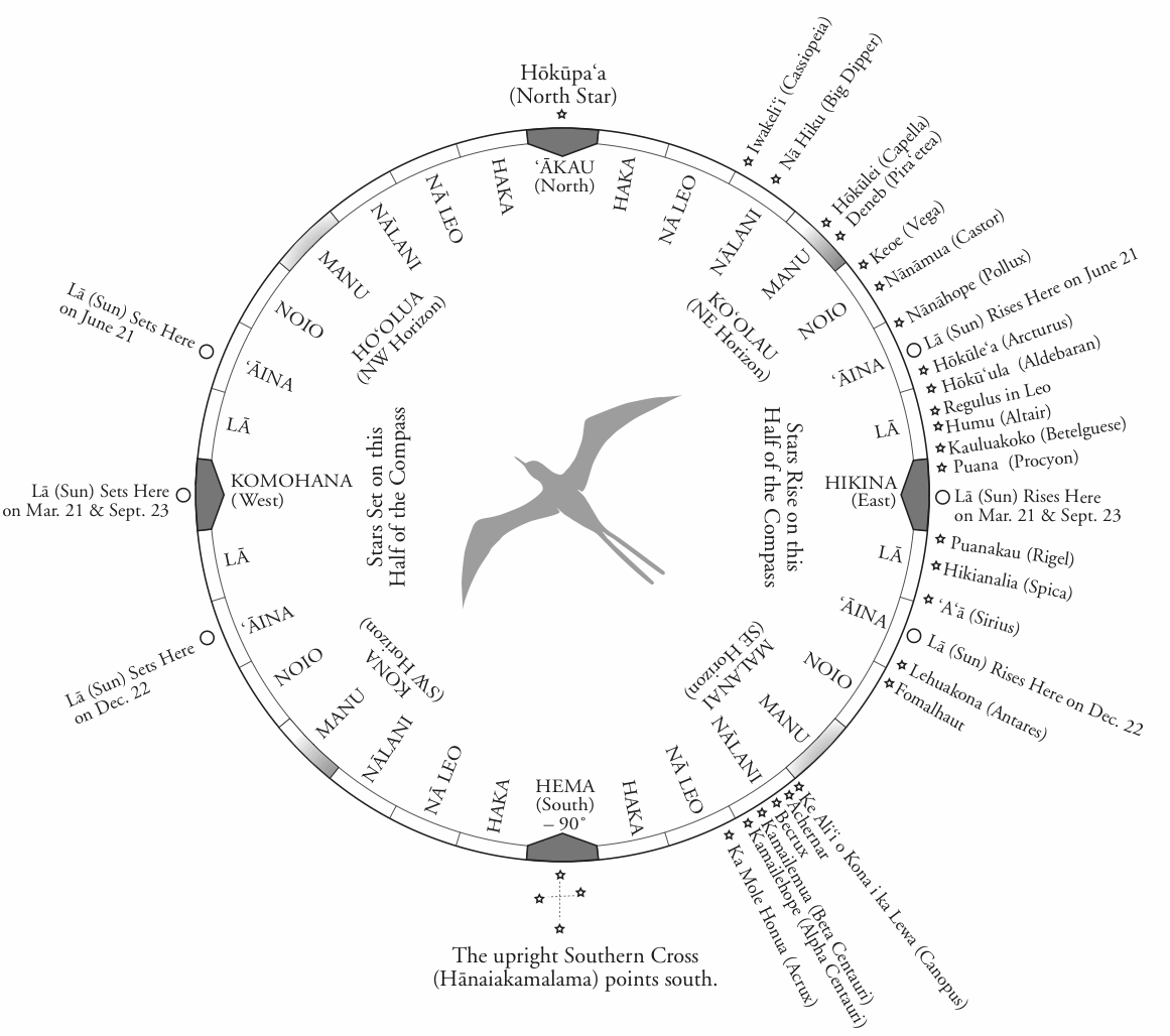
The star compass also reads the flight path of birds and the direction of waves. It does everything. It is a mental construct to help you memorize what you need to know to navigate.
You cannot look up at the stars and tell where you are. You only know where you are in this kind of navigation by memorizing where you sailed from. That means constant observation. You have to constantly remember your speed, your direction and time. You don't have a speedometer. You don't have a compass. You don't have a watch. It all has to be done in your head. It is easy-in principle-but it's hard to do.
The memorization process is very difficult. Consider that you have to remember those three things for a month-every time you change course, every time you slow down. This mental construct of the star compass with its Hawaiian names is from Mau. The genius of this construct is that it compacts a lot information and enables you to make decisions based on that information.
How do we tell direction? We use the best clues that we have. We use the sun when it is low down on the horizon. Mau has names for the different widths and the different colors of the sun's path on the water. When the sun is low, the path is narrow, and as the sun rises the path gets wider and wider. When the sun gets too high you cannot tell where it has risen. You have to use other clues.
Sunrise is the most important part of the day. At sunrise you start to look at the shape of the ocean-the character of the sea. You memorize where the wind is coming from. The wind generates the waves. You analyze the character of the waves. When the sun gets too high, you steer by the waves. And then at sunset you repeat the process. The sun goes down-you look at the shape of the waves. Did the wind direction change? Did the swell pattern change? At night we use the stars. We use about 220, memorizing where they come up, where they go down.
When it gets cloudy and you can't use the sun or the stars all you can do is rely on the ocean waves. That's why Mau told me once, "If you can read the ocean you will never be lost." One of the problems is that when the sky gets black at night under heavy clouds you cannot see the waves. You cannot even see the bow of the canoe. This is where traditional navigators like Mau are so skilled. Lying inside the hull of the canoe, he can feel the different wave patterns as they come to the canoe, and from them tell the canoe's direction. I can't do that. I think that's what he started learning when he was a child with his grandfather, when he was placed in tide pools to feel the ocean.
In 1979, when Mau was confident that I could guide the canoe by myself, he said, "Now I am going to go to sleep; you follow this star path." And like an overly eager student, I wanted to try sailing in a different direction to experience what the wave patterns felt like when I changed directions. I thought he wouldn't notice because he was sleeping inside the hull. When morning dawned, he came up and said, "Okay, what course did you sail last night? What star bearing did you hold?" He knew I had changed course. Lying in the hull, he actually knew the course I had steered; he challenged me to tell him in order to make sure that I knew where we had gone.
Tahiti is smaller than Maui and it is a hard target to hit from 2500 miles away. Even hitting a target as large as the Big Island from that distance is outside of the accuracy of our navigation. When we go down to Tahiti, we have a mental image of our course line plotted for the trip. We try to stay on this course and end up in what I call a box. (See the map of the 1980 voyage to Tahiti.) This box is large enough to compensate for any errors in our navigation. In this box there are many islands. All we have to do is to find one of them, and from that island we can find the others. For example, the target when we sail to Tahiti is a box four hundred miles wide, from Manihi in the Tuamotu islands to Maupiti in the leeward Tahitian islands. The first part of the journey to Tahiti is not trying to get to Tahiti but to make sure that we sail into this box and find an island. On different voyages, we have found Matahiva, Tikehau, and Rangiroa-all islands in the box. Since these are coral atolls it is very difficult to tell one from the other, so sometimes we have to land and ask the people what island it is that we've found. From any of these islands, we know Tahiti is only about 170-180 miles away and our navigation system is accurate enough to find it from that distance.
Now consider another navigational problem-finding Hawai'i from Tahiti. The Hawaiian islands are 315 miles wide, from Ni'ihau to Kumukahi on the Big Island, but if you approach them from the southeast they are a narrow target because they are aligned southeast to northwest. The technique we use is to sail up to the latitude of Hawai'i on the east side of the islands, using the stars to tell our latitude. When we determine we are at the mid-latitude of Hawai'i, 20.5 degrees N, we turn west and try to sail into the islands on this side, 240 miles wide-the sight distance from South Point on the Big Island [18.5 degrees N] to the sight distance from Hanalei on Kaua'i [22.5 degrees N]. Again, our navigation system is accurate enough to hit this target. (See the map of the 1980 voyage to Tahiti.)
The Southern Cross is really important to us in determining latitude. It looks like a kite. The top and bottom stars in the kite always point south-Gacrux on top and Acrux on the bottom. If you are traveling in a canoe and going south, these southern stars are going to appear to be moving higher and higher in the sky. If you went down to the South Pole, these stars are going to be way overhead. If you are sailing from Tahiti north to Hawai'i, the Southern Cross gets lower and lower the farther north you go. At the latitude of Hawai'i, the distance from the top star to the bottom star is the same distance from that bottom star to the horizon about 6 degrees. This configuration only occurs at the latitude of Hawai'i.
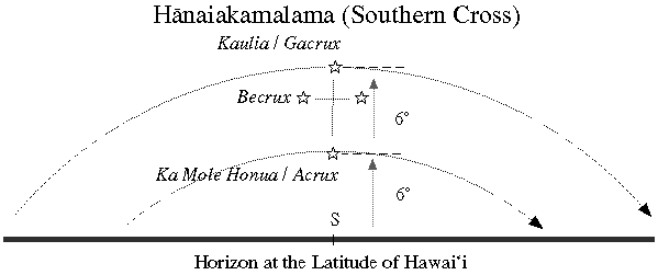
If you are in Nukuhiva in the Marquesas Islands and looking at the Southern Cross, the distance between the bottom star in the Southern Cross and the horizon is about nine times the distance between the two stars.
Finding atolls, which are very low, is extremely difficult, but there are a lot of clues to the presence of islands. The wave patterns change when an island is near. The behavior of animals in the sea, such as dolphins, will change. Mau can read these clues. The main guide is sea birds. There are two general types of seabirds that Mau taught us about. There are the pelagic seabirds-after the young are hatched and learn to fly, they go to sea and stay there, normally sleeping on the water or in the air and fishing until they become adults; then they come back to land to nest. The 'iwa bird is pelagic and we see it all the way across the ocean. Following these birds will not help you find land. The other type of birds are those that sleep on islands at night and at dawn go out to sea to fish. These land-based birds include the manu o ku (white tern) and noio (brown tern). Noio go about 40 miles out; the manu o ku go about 120 miles out. The Tuamotus are filled with these birds.
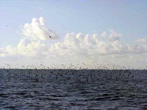
A large bird pile near Rangiroa Atoll in the Tuamotu Archipelago. Photo by Na‘alehu Anthony
After we sail about 29 days down from Hawai'i and staring seeing these birds, we know the islands are close even though we can't see them. When the manu o ku is fishing, it flutters above the ocean surface, but when the sun starts to go down, it will rise up from the water so it can see farther, and it will head straight back to land. When we see these birds in the day we keep track of them and wait for the sun to get low and watch the bird; the flight path of the bird is the bearing of the island. Then we turn on that bearing, sail as fast as we can, and at sunset we climb the mast to see if we can find the island. And if we can't see it, we heave to until the morning.
On my first voyage in 1980, we saw two birds after the 29th day and I was extremely relieved. At least we were in the ball park. I did everything that I was taught to do and the birds did everything that they were supposed to do. They went up high and they flew away and we sailed in that direction. We couldn't see the island at sunset, so we took the sails down at night and we waited. The next morning we looked for the birds to see what direction they were coming from. In the morning they go back out to the fishing ground, so the direction they are coming from is the direction to the island. We had a great crew of 14 and we made a ring around the canoe before dawn. We waited for the first bird. All hands on deck. Not a single bird. I was in near trauma-my first voyage, in my early twenties. Mau was very calm and didn't say anything. We waited and waited. The canoe was just sitting dead in the water, facing south.
One of the canoe members was in the back of the canoe and a bird flew right over his head. The night before we saw the birds flying south so how could it be that late in the morning with the sun very high, this bird was also flying south? That would suggest that we passed the island during the night and now the island was back to the north. In my panic, I told the crew we should turn the canoe around and go north-to look for the island the bird was coming from. They turned the canoe around-and now we are sailing north, back toward Hawai'i. Now Mau has always said that his greatest honor would not be as a navigator but as a teacher-that he would come with us to make sure that the voyage to Tahiti would be safe, but if he didn't have to tell me anything, the honor as a teacher would be his. But after I started to sail north he came to me and said, "No." It was the first time that he interrupted the trip. He said, "Turn the canoe around and follow the bird." I was really puzzled. I didn't know why. He didn't tell me why, but we turned the canoe around and now we saw other birds flying south. Mau said, "You wait one hour and you will find an island."
After about an hour, Mau, who is about twenty years older than me-my eyes are physically much more powerful than his-got up on the rail of the canoe and said, "The island is right there." We all started looking, and we couldn't see it. Vision is not so much about just looking, but knowing what to look for. It's experience. Mau had seen in the beak of the bird a little fish, and he knew that the birds were nesting, so they had flown out earlier that morning and were taking food back to their young before they fed themselves. He just did not tell me that in our training program.
Not everybody can navigate. We have some great navigators in Hawai'i – Shorty Bertelmann from the Big Island; my brother-in-law, Bruce Blankenfeld from O'ahu; and Chad Baybayan from Maui. We base our projected course line before the voyage on average winds and sea conditions for 24 hours, but these are never average. The majority of navigation is observation and adjusting to the natural environment. The rougher the weather, the more the navigator needs to be awake and the less he can leave the crew on their own. We estimate that our navigators stay up between 21 and 22 hours a day, sleeping in a series of catnaps.
Mau says the mind doesn't need much rest. But the physical body does. When the navigator is on the canoe, the crew does the physical work. When he is tired, he closes your eyes. Mau told me that for him maybe his eyes are closed but inside here, inside his heart, he is always awake.
The navigator sleeps whenever his mind needs to rest. You work until you can't think, basically, then you lie down. I close my eyes and go to sleep. I have no dreams in the beginning. My first dreams are fire. I see reds and oranges. Then I get up when my mind is awake again. I do a series of those catnaps. The main thing is to make sure that your physical body doesn't do any work because then you get sick.
Initially, I depended on geometry and analytic mathematics to help me in my quest to navigate the ancient way. However as my ocean time and my time with Mau have grown, I have internalized this knowledge. I rely less on mathematics and come closer and closer to navigating the way the ancients did.