Voyage to Rapanui
Leg 1. Hawai'i to Nukuhiva, Marquesas Islands (June 15-July 13, 1999)
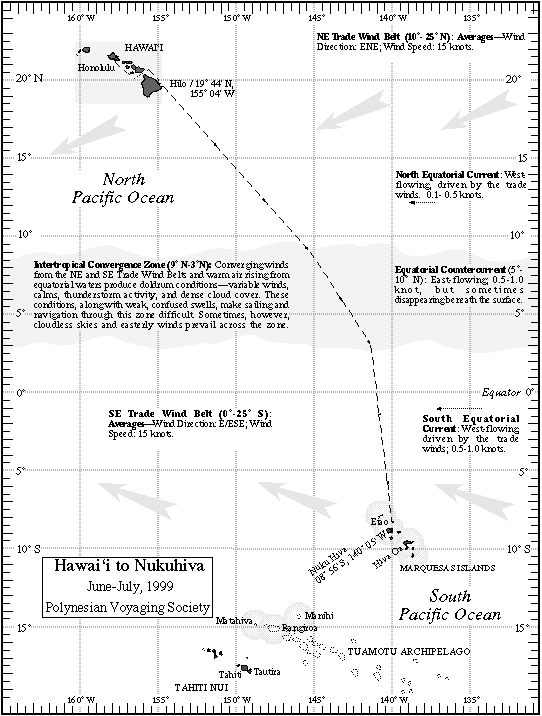
On the first leg of the voyage to Rapanui, Hokule'a sailed to Nukuhiva (08° 56' S, 140° 05' W; Highest Point, Tokao at 3890 ft.), in the Marquesas Islands, which lies SE by S/SSE of Hawai'i.
The Marquesas is a chain of islands, from Eiao (8° 00' S, 140° 41' W) in the Northwest to Fatu Hiva (10° 28' S; 138° 50'W) in the Southeast, extending 148 miles north to south and 110 miles east to west. Nuku Hiva is the administrative center; other major islands are Ua Pou, Ua Huka, Tahuata. Hiva Oa.
Sailing Strategy
Hokule‘a needed to make about 900 miles of easting to reach its destination. She sailed close to the easterly trade winds south down to 10 degrees N. Between 10 degrees N and the equator (Intertropical convergence zone), she may encounter doldrum conditions (light winds; often cloudy weather and thunderstorms). At around 9° S, the mid-latitude of the Marquesas, the navigators will look for land-based sea birds and other signs of land.
Captain/Navigator: Bruce Blankenfeld (O'ahu)
Assistant Navigator: Pi'ikea Miller (O'ahu)
Watch Captains: Dennis Chun (Kaua'i), Terry Hee (O'ahu), Leon Sterling (Maui)
Crew: Russell Amimoto (O'ahu), Desmon Antone (Maui), Darcy Attisani (Kaua'i), Kekama Helm (Moloka'i), Ka'au McKenney (O'ahu), Atwood Makanani (Kaua'i), Hau'oli Smith (O'ahu; Sausalito, CA), Wallace Wong (Hawai'i).
Esort Boat Kama Hele: Captain: Alex Jakubenko (O'ahu); Crew: Elsa Jakubenko (O'ahu), Tai Crouch (O'ahu), Tim Gilliam (Maui), Kealoha Hoe (O'ahu), Sean McKeever (Maui), Gary Suzuki (Lana'i).
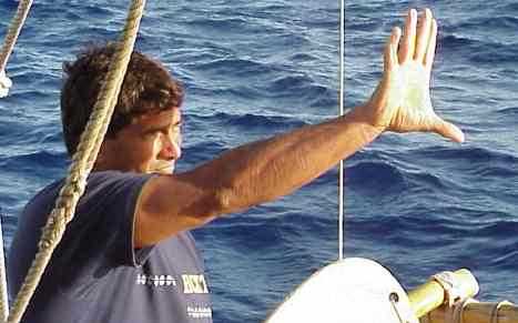
Bruce Blankefeld navigating
For the first time, Hokule'a sailed from Hawai'i to the Marquesas, considered a difficult sail even in a deep-keeled monohull, because the Marquesas lie 900 miles upwind of Hawai'i. The canoe was able to make up this easting because of the sailing skill of the navigators and crew, the lighter canoe (4000 pounds have been removed), and new sails, which allows Hokule'a to point higher into the wind (6 to 11 degrees higher) than with the old rig.
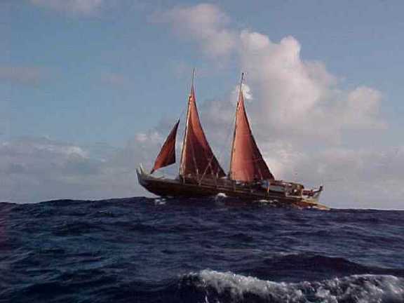
Hokule‘a with New Rig for the Upwinds Sail on the 1999 Voyage to Rapanui
The New Sails of Hokule'a
Hokule'a is outfitted with two new sails, the fore sail 290 square feet and the back sail 318 square feet. (The back sail is slightly larger to give the canoe weather helm (i.e., drive the canoe closer to the wind when it tries to get easting in the easterly trade winds.) The sails are different from the sails Hokule'a has used in the past (drawing by Honolulu Star-Bulletin artist David Swann). The new sails on Hokule'a look like the old ones turned upside down, without the booms, and are made of dacron instead of canvas.
Why the new sails?
1. The new sails, made out of dacron rather than cotton, are stronger and lighter than the old sails; they also have less stretch in them, allowing the canoe to sail without a boom.
2. The new sails allow the crew to shape each sail more effectively, eliminating an area of induced drag that used to form near the outer top corner (the clew) of the old sail.
3. The new sails, without booms along their lower edge allows the wind to come cleanly off the sail, producing more drive and lift. In short, the sails are more aerodynamic than the old sails (no turbulence created by the booms).
4. Without the booms, the canoe is lighter; also there is less weight aloft and the center of effort is lower, so the canoe is more stable.
5. Without the booms, the canoe is safer, as there are two fewer wooden parts to break or to injure someone while the rigs are being raised or lowered.
6. The greater efficiency of the sails allows the canoe to point closer to the wind: 56-60 degrees from the wind rather than 67-70 degrees with the older sails. This better windward ability will allow the crew to make more easting against the easterly trade winds in the northern and southern hemispheres-necessary on the first three legs which will take the canoe 3000 miles to the east of Hawai'i.
The main disadvantage of the new sails is that they put more pressure on the spars, making the spars more prone to breakage; and (2) the full pull of the sail is concentrated where the sheet lines from the clews of the sails are attached to the back manu; to compensate a second sheet line was added, attached to a side railing.
A Controversial Use of Non-Traditional Sails?
The new sails are non-traditional in design and materials. The Polynesian Voyaging Society recognizes this. We also know that the canoe might not have completed the voyage to Rapanui using the old rig, as the windward ability of the canoe with the old rig would not allow the canoe to get 3,000 miles upwind from Hawai'i.
Yet we know such voyages were made from Hawai'i to the Marquesas, from Marquesas to Mangareva, and from Mangareva to Rapa Nui. The fact that Polynesians reached these islands is beyond dispute. Oral traditions and archaeological findings suggest the settlers to Rapa Nui came from the Marquesas or Mangareva. How they made the voyages, given the traditional sail design and materials, is not known. But clearly, to have made these voyages, these ancient sea people must have been extraordinary canoe builders, sailors, and navigators. The Polynesian Voyaging Society retraces these migration routes with great humility, knowing that the ancient mariners who first traveled them did so without the advantages of the modern materials and designs that we use today.
Even though PVS could not sail the routes using the same canoes and sails that the ancient did, the journey was important enough to make for the following reasons:
--to honor the people who found and settled Rapa Nui. Rapa Nui is the most isolated high island on Earth, and its discovery and settlement by Polynesian voyagers is one of the great accomplishments of exploration in human history. How did they find such a small island, over a thousand miles upwind of the nearest Polynesian settlement? What sailing strategies and navigations systems might they have used, given the environmental conditions along the route?
--to honor our elders and kupuna and the many others who contributed to voyaging and its revival in the last 25 years.
--to train a younger generation of deep sea sailors and navigators to perpetuate Hawai'i's proud traditions of voyaging and navigation.
--to explore our history and learn more about the history of Rapa Nui: By the time Europeans reached the island in the 18th century, it was practically treeless. No canoes. What happened to the trees? Because of the limited size of the island, perhaps the population outgrew the capacity of the island to support the people; or some natural disaster (e.g., a prolonged drought) may have caused the island environment to deteriorate beyond recovery. What lessons does the history of Rapa Nui have for Hawai'i and the planet earth?
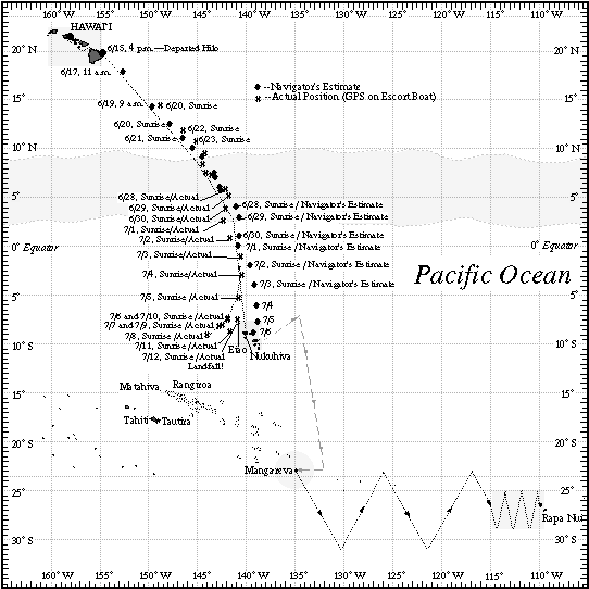
Navigator Bruce Blankenfeld, assisted by Pi'ikea Miller, was able to hold the course line (the desired course) through the three segments of their voyage: Manu Malanai (SE) in the ENE trade winds (21 N to 9 N), Nalani Malanai (SE by S) through the doldrums (9 N to 3 N), and Na Leo Malanai (SSE) in the easterly SE trade winds (3 N to 9S).

Pi'ikea Miller
On July 5, the navigators took a southwesterly course to try to intersect the Marquesas islands on its long 190-mile wide SE to NW axis (8 S to 10.5 S). However, they had been over-estimating their distance travelled and latitude (by 2-3 degrees), and were actually still north of the islands. On July 6, they sailed 90 miles WNW of Eiao on their southwesterly course, away from the Marquesas.
Finding no signs of land by July 8, the navigators ended their search to the west and south and guessed that they must have gone past the islands earlier. They headed back to the east, directly into the ESE tradewinds. They zigzagged east between 7.5 and 9 degrees S in a search strategy to find the Marquesas. At 2 a.m. on July 11, they felt the islands in the change of pattern in the trade wind swells, which were blocked and disturbed by Eiao and Hatutu about 10 miles WSW of the canoe. On morning of July 12 they sighted land in the squally weather--the edge of Eiao.
Navigating this route without instruments was another milestone in voyaging. This relatively tight, isolated cluster of high islands (120 x 160 miles) is difficult to find from 2000 miles away. The target for Hokule'a on previous voyages to Tahiti--a 400-mile wide screen, from Manihi in the Tuamotu Archipelago, to Maupiti in Tahiti Nui--is 2-3 x wider than the Marquesas.
Entered Taiohae, Nukuhiva, July 13, 1999, p.m.
Hokule'a was at Sea: 28 days
Miles from Hilo (Straight Line): 1900; Miles Along Reference Course Lines: 2140; Miles Actually Sailed: 2700.
The skills, strategies, and equipment that the navigators and crew tested on this first leg will be needed on the next two voyages, when Hokule'a will have even smaller targets than the Marquesas. On the second leg from the Marquesas to Mangareva, the navigators (Chad Baybayan, with Moana Doi and Catherine Fuller) will aim for a group of three islands (Oeno, Pitcairn, and Henderson) that is smaller, lower, fewer in nubmer, with wider gaps between them than the Marquesas group. The navigators will again have to sail close to the wind; they plan to tack north to gain enough easting to avoid the dangerous reefs and atolls of the eastern Tuamotus before heading south to find the three islands and Mangareva.
The third leg of this voyage will take the canoe from Mangareva in search of Rapa Nui, one of the most isolated islands on the planet, and directly upwind of the departure point of Mangareva. Under typical wind conditions, the navigators--a team of Hawai'i's best incluidng Nainoa Thompson , Bruce Blankenfeld, and Chad Baybaybn--cannot sail a straight course to the islands; instead they will tack against easterly winds and play wind shifts. Toward the end of their voyage, they will employ the same zigzagging search strategy that navigators Blankenfeld and Miller employed to find the Marquesas.
Reports from Hokule‘a
June 15
Hokule'a departed today around 4 p.m. from Hilo, Hawai'i (19 degrees 44'N, 155 degrees 04' W). The trade winds are still light, but beginning to fill in as a high pressure system builds to the NE of Hawai'i....predicted for tomorrow: ENE 10-25 knots.
Three ceremonial events were held before departure:
On June 10, the crew went up to Keanakako'i Adze Quarry near the summit of Mauna Kea, Hawai'i.In ancient times, basalt stones from this quarry were flaked and chipped into adzes used to carve canoes. Kaipo Frias chanted the crew into the quarry and called upon the gods. Mauna Kea is the first born child of Papa, the earth mother, and Wakea, the sky father. Crew members were allowed to commune with and pray to the spirits for guidance and protection and a safe voyage home. Visiting Mauna Kea is appropriate at the start of a voyage to the South Pacific because it is a beacon of home. This two-mile high mountain is the tallest in Hawai'i and one of the most likely physical manifestations that voyagers will sight when looking for the islands on the voyage home next January.
One June 12, the crew went up to the Kilauea Forest Reserve on the slopes of Mauna Loa to plant koa seedlings. This action was symbolic of the need to restore Hawai'i's koa forests, which have been destroyed by logging and cattle ranching over the years. The koa tree was used for the hulls of canoe. The planting was dedicated to Wright Bowman, Jr., master canoe builder, who passed away in 1997. Wrighto, as he was known by friends, supervised the building of the voyaging canoe Hawai'iloa.
On June 13, at the Naniloa Hotel on Hilo Bay, a ceremony was held to bless the canoe and focus the crew on the upcoming voyage and the return to Hawai'i with new knowledge about the ocean, the weather, and the Polynesian islands and peoples to the south. The first cup of 'awa was offered to the two ki'i of the canoe, a male god (symbolizing knowledge) attached to the back right manu and a female (symbolizing vision) attached to the back left manu.
June 17
Hokule'a is on course, about 200 miles out of Hilo. Both crews (Hokulea and Kamahele) are settling into watch routines and making adjustments to life at sea. Tradewinds at 10-25 knots, sloppy seas, occassional squalls. Fishing Report from Kamahele: One 20 lb. mahimahi eaten at lunch
June 19
Hokule'a is on its intended southeasterly course, about 450 miles out of Hilo, making excellent easting. ENE Tradewinds at 20-25 knots, squally. Fishing Report from Hokule'a: 7-9 lb. aku; "just a baby."
June 20
Easterly Tradewinds at 15-18 knots. The canoe is self-steering in balance against the wind. New free-footed sails are working well and the canoe is tracking smoothly. Average speed of canoe--4-5 knots. Clear skies and sunny weather. Seas 3-4 feet. The deck is wet from sea spray and an early morning squall, but the crew is in good health and spirits.
Navigation: intermittent cloudiness last night, with periods of clear skies; navigating by Hokupa'a (Polaris), Maui's Fishhook (Scorpio), Altair and Vega, Mercury, Venus, Mars, and the Moon. The two predominant swells are from the ENE and ESE, generated by the trade winds.
June 21
Hokule'a's crew woke up this morning to a solid wall of clouds to the SE. As of 8:00 a.m., the sky was 100 % cloud covered, with high grey-white stratus clouds above cumulus clouds. The wind has been holding at ENE, 10-20 knots, becoming gustier. Air temparature is warming and humidity is increasing as the canoe heads toward equatorial waters. Everyone's hair and clothing is damp, but good spirits continue. Malolo (flying fish) landed on deck at night.
June 22
The navigators corrected their estimated latitude to 10 degrees N at sunrise, based on a good measurement of the altitude of Hokupa'a, the North Star, with Alkaid parallel to Hokupa'a (i.e. when the the North Star is close to the height of the North Celestial Pole). They decided they have been overestimating their speed and distance traveled.
After a day of cloudly, squally weather, choppy seas, and gusty winds, the sky cleared last night at about 9 p.m. Weather today is sunny, with winds ENE at 15 knots. Sea Life: 'A (Boobies), shearwaters, ko'ae kea (white-tailed tropic birds)
June 23
Winds are diminishing. ENE 10-15 knots. Clear skies and drier air. The navigators feel that based on their dead reckoning and latitude measurements, Hokule'a should be approaching the Intertropical Convergence Zone, but no sign yet of heavy clouds associated with the ITCZ.
Two spouts sighted in the distance...whales, though too far to identify what kind of whales. Navigator Blankenfeld says whales are signs of good luck. A pile of birds fishing in the distance...too far to identify what kind of birds.
Crew spirits are good: 4 musicians, 1 massage therapist, and 10 comedians on board.
The Navigators are resassessing their position, and feel they may be farther east of their reference course than they thought because earlier they had factored in too much current drift to the west.
June 24
Doldrum conditions: winds have dropped off to 5 knots, variable from ENE to ESE, mainly easterly. Canoe speed is down to 3 knots.
Believing that the canoe has passed 9 degrees N, the navigators changed to a more southerly heading last night, holding Nalani Malanai (SE by E). (see course strategy explanation.) The canoe heading this morning is now even more southerly, Haka Malanai, or S by E, with winds out of La Malanai (E by S). Skies are clear but occassional passing squalls; squall lines can be seen in the distance.
More whales sighted, possibly sperm whales or large pilot whales. A school of aku is following underneath the canoe, but no fish are biting at the lures.
June 25
With a good sighting of Hokupa'a in the crystal clear predawn sky, the navigators have determined that they have been overestimating the distance they have traveled to the south and have once again adjusted their estimated latitude. (The lower Hokupa'a gets to the horizon, the more accurate the measurement of its altitude with one's outstretched hand and the more accurate the esimate of latitude.)
Doldrum conditions have dissipated. Hokule'a is sailing under clear skies with cumulus clouds and seas of 2-3 ft. (Hokule'a is passing between two areas of cloudiness in the Intertropical Convergence Zone.) Winds are coming out of the east at 10-15 knots and the steersperson is holding Nalani Malanai (SE by S), 41 miles east of the reference course line. There is a small swell coming out of the south.
A pod of dolphins has been traveling with the canoe over the last day.
June 26
Hokule'a was back in the doldrums this morning. With winds 5-10 knots from the ESE, the canoe was making 2 knots, heading hema (S).
Yesterday afternoon at about 3 p.m., a big squall hit the canoe. The crew took advantage of the fresh water to take showers and gather about 20 gallons of rainwater.
The sky was intermittently clear last night, as the navigators steered by the Navigator's Triangle (altair, vega, and deneb) rising in the early evening; the Venus, Spica, Mars, and the Moon setting; Hokupa'a due north.
The crew closed the sails at about 3 a.m. last night, as the canoe was making no progress in the light airs. They opened the sails again this morning after sunrise, when the winds picked up a little.
Sea Life: terns, one dark and one light-colored, were following the canoe. (perhaps these birds are from the Line Islands to the west.)
June 27
Doldrum conditions continue. Winds 0-5 knots, variable, but tending to be from La Malanai (E by S) to Manu Malanai (SE). Hokule'a was making 1 knots, heading Na Leo / Haka Malanai (SSE/S by E).
Yesterday afternoon and last night the variable winds turned south and the canoe tacked E; the crew closed the sails for a time last night as the canoe made no progress in the light airs. Between sunset and sunrise, the canoe progressed 4.6 miles south and 20 miles east.
The seawater used for bathing and washing the deck, pots and dishes and clothing is getting warmer as the canoe heads towards the equator. Sea Life: pod of sperm whales.
June 28
Hokule'a was hammered by squalls last night and early this morning, line after line hitting the canoe. The weather is still squally as of 9:30 this morning. Over the past 24 hours, the canoe has been averaging 5 knots, doing 3.5 knots in light winds between the squalls and 7 knots in heavy winds, gusting up to 30 knots. The crew did not tack yesterday. Current heading is Nalani Malanai (SE by S) at 5-6 knots, with winds at 20-25 knots, variable but mainly easterly.
The SE swell continues to come out of the SE Tradewind Belt; the NE swell out of the NE Tradewind Belt, but the seas are messy and difficult to read with swells generated by passing squalls mixed in.
The canoe has been performing "fantastic," according to Navigator Bruce Blankenfeld. And despite the squally weather, the crew is doing fine.
Fishing report: Lost one lure; one lure missing half a skirt and the hook--sharks biting?
Sea Life: pod of dolphins wake riding at the bow of the canoe early last night; shearwater sighted yesterday.
June 29
Squally weather continued over the last 24 hours, with lots of rain and variable winds. Current heading is Hema (S) at 4.5 knots, with winds at 20-25 knots, variable but mainly La Malanai (E by S).
Seas are messy and difficult to read due to mixed swells generated by passing squalls; navigation is difficult with cloudy skies.
Sea Life: Shearwaters--birds of the open ocean.
June 30
Hokule'a seems to have broken out of the doldrums as of last night. The last big squall came through in the early evening. This morning the sky was 90% covered with alto stratus clouds, but the cloud layer seemed to be burning off with the rising sun, and clear skies and cumulus clouds could be seen in the direction of the weather. Winds were coming out of 'Aina-Noio Malanai (ESE - SE by E) at 15 knots, suggesting the canoe was entering the Southeast Trade Wind Belt.
The current heading is Haka Malanai (S by E) at 4 knots. According to radio operator Hauoli Smith, Hokule'a is "like a racehorse heading for the barn," on the third and last segment of the voyage to Nukuhiva. The crew is drying out from all the rain over the last few days.
The SE tradewind swell is dominant now.
Sea Life: Shearwaters and petrels--birds of the open ocean. One large lone whale spotted in the distance, too far away to identify the kind of whale.
July 1
Navigators adjusted their latitude estimate to 01 degree N last evening with a good sighting of Hokupa'a, the North Star, which appeared just above the horizon.
This morning the skies are clear and full of cumulus clouds--a beautiful day at sea. The winds were from La Malanai (E by S) at 15 knots and the canoe was heading Na Leo Malanai (SSE) at 5 knots. The seas were mellow and the swells were sorting themselves out after the confused patterns of the doldrums: the dominant swell from the SE, and a smaller easterly swell. The crew was in good spirits.
Last night the skies were clear, with all the stars available of navigation. Anticpating they would crossing the equator soon, the crew held their equator crossing party--an 'awa ceremony, skit, and a special dinner, with Spanish rice and crepes with banana with chocolate syrup.
Sea Life: An 'Iwa (Frigate Bird) came hovering over the canoe just before sunset. One large lone whale--dark with a small fin on its back--perhaps a fin whale. Other birds: shearwaters, 'ake'ake (petrels), and terns.
July 2
With a good clean east wind blowing at 15-22 knots, Hokule'a was ripping along at 6 knots in the direction of Nalani Malanai (SE by S). Pi'ikea Miller, Apprentice Navigator, reports "the canoe feels like it's flying, not even touchng the water." The easterly component in the SE trades is allowing the canoe to make back some of the easting it lost in the doldrums.
Last night and this morning, the skies are clear and full of cumulus clouds--another beautiful day at sea. The seas are ten feet and the dominant swell continues out of the SE, with a smaller swell out of the east.
Sea Life: Boobies have appeared for the first time; other seabirds: shearwaters.
July 3
Winds have lightened, to 10-15 knots, and shifted S of E. Hokule'a is heading Haka Malanai (S by E), at 5 knots. The present course would take the canoe directly to Nukuhiva in about 4 days. SE and ESE swell diminishing. Radio transmission was very poor; position and direction and speed report only.
Sea Life: Shark sighted by the escort boat Kamahele at 6:45 a.m. yesterday; sighting of a single boobie between Hokule'a and Kama Hele this morning
July 4
Hokule'a continues to head Haka Malanai (S by E), doing 6.5 knots in 15 knots of easterly wind. The seas are moderate at 6-8 ft. with swells from Noio Malanai (SE by E) and Hikina (E). The weather is clear and sunny, with cumulus clouds.
The crew was finally able to hook another fish....a 20 lb. aku, which they ate for breakfast this morning. It was the first fish caught since the 7-9 lb. aku hooked on June 19.
Latitude: The navigators used Pherkad and Kochab in the Little Dipper and Alrai in Cepheus for latitude estimates last night. These stars transit the meridian above the north celestial pole after midnight and in the early morning before sunrise.
Sea Life: terns, boobies.
July 5 Searching for Islands
The crew of Hokule'a are heading Na Leo Kona (SSW) looking for islands and birds today, doing 6-7 knots in 15 knots of easterly wind. The weather is clear and sunny, with cumulus clouds. The seas are 4-8 feet and whitecapped, with swells coming from the E and ESE. Last evening, the swells became very steep, and the canoe began rocking and rolling. The navigators speculated that they were passing over a shallow spot in the ocean.
The navigators readjusted their latitude estimate last night after a good sighting of Kochab and Pherkad crossing the meridian. Latitude, determined by dead reckoning of distance traveled and the altitude of stars crossing the meridian due north and south, is difficult to measure precisely without instruments. The altitude of the stars are measured by the navigator's outstretched hand calibrated to distances in the celestial sphere. The higher the latitude star is from the horizion, the less accurate the estimate of its altitude and therefore, latitude.
The navigators have traveled their intended course the whole way. The last step now is the find the islands.
Strategy: Estimating the canoe is about 72 miles north of Nukuhiva, the navigators plan to looks for land-based seabirds heading back to the islands today at sunset.
Sea Life: one manuoku (white tern), one noio (brown tern); one 15 foot whale shark
The sail to the Marquesas has been awesome! With its new sails, Hokule'a is more than capable of making the 900 miles of easting needed to reach its destination.
July 6
The navigators estimated they were at 9 degrees 15 minutes S at sunrise and are searching for islands and birds this morning. No sightings yet. The wind was coming out of 'Aina Malanai (ESE) at 10-15 knots--typical trade wind weather. Moderate seas, 4-6 feet.
The navigators took latitude readings last night from Pherkad and Kochab in the Little Dipper. At the latitude of the Nukuhiva (9 degrees S), in July, Kochab transits the meridian at about 7 degrees above the horizon at 9 p.m.; Pherkad, paired with the star Ed Asich directly above it transits at about 9 degrees above the horizon at 9:48 p.m.
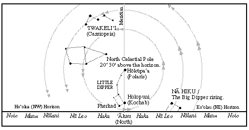
Pherkad and Holopuni transiting meridian in Hawai‘i. In Nukuhiva, the North Celestial Pole is 9 degrees higher, so the transit of Pherkad and Holopuni also transit higher.
Fishing report: caught a 20 lb. ono (wahoo).
July 7
The navigators estimated they were at about 10 degrees S at sunrise and are tacking and searching for islands and birds this morning. Pairs of terns were sighted flying west in the early morning. The navigators have been searching to the west up until now and plan to reassess their position today. The Marquesas actually lie to the east.
The wind was coming out of La Malanai (E by S) at 10-15 knots--typical trade wind weather. Moderate seas, 4-6 feet.
The navigators took latitude readings from Kochab in the Little Dipper last night. At the latitude of the Nukuhiva (9 degrees S), in July, Kochab will transit the meridian at about 7 degrees above the horizon at 9 p.m.
Strategy: The navigators are in the final phase of their voyage--tacking between about 8 and 10 degrees S while looking for land-based seabirds and islands.
July 8 Tacking back east, searching for islands
The navigators continue to search for the Marquesas. Yesterday afternoon they headed south to look for the islands; by sunset, they were heading S by E against the easterly trades, believing now that the islands lie to the east. This morning they tacked back toward the NE and will continue on this tack until sunset.
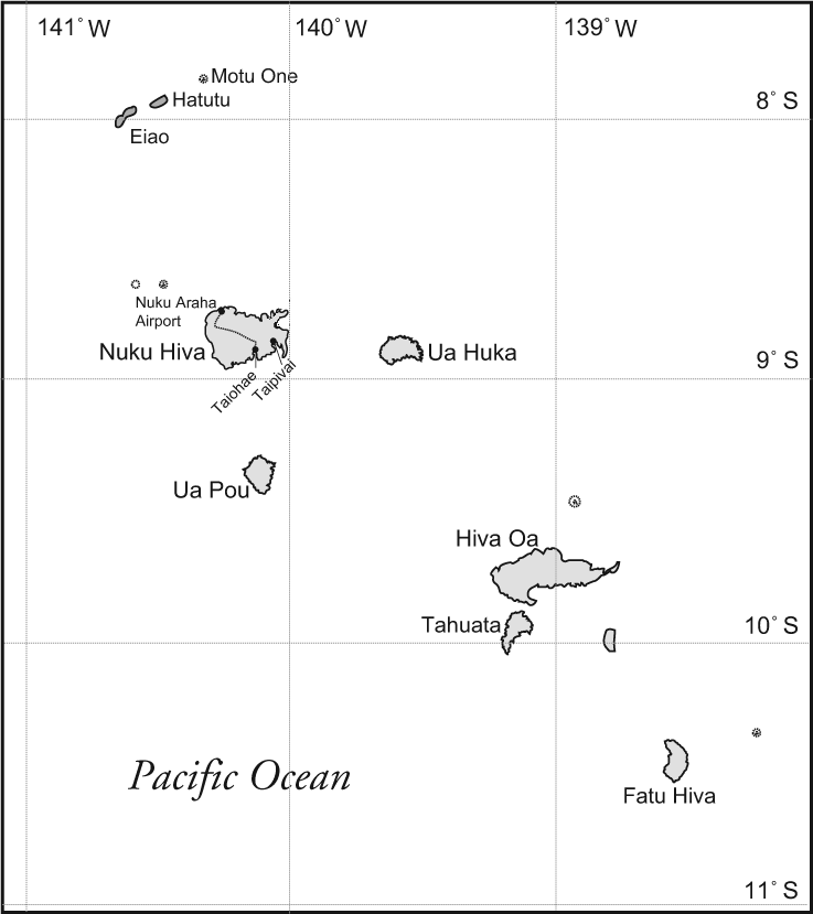
Eiao, the northernmost of the Marquesas Islands lies 190 miles to the east and tacking back to it against the easterly trades will take at least 4 days.
Are the navigators "off course"? At this point in the voyage, there is no intended course. The intended course line was the line the navigators sailed from Hawai'i down to the vicinity of the Marquesas and they held that course as long as they thought it was necessary. Now the navigators are carrying out a search strategy to find the islands. This involves tacking back and forth at the latitude of the islands--either to the east or to the west.
The art of wayfinding doesn't produce data for precise latitude and longitude; it doesn't guide a vessel directly to a destination. Wayfinding involves continuous orientation and re-orientation (which is why the navigator gets very little sleep), based on estimates of speed and distance traveled and clues in the natural environment. Because navigators without instruments cannot pinpoint a destination, they sail into the vicinity of their destination and if they don't find it where they think it is, they employ a search strategy to find it.
On July 5, based on their estimated distance traveled and readings of latitude stars, the navigators believed that the islands were to the SW and starting searching in that direction. Now they have decided that the islands were not in that direction (no sighting of land clues), so they have reversed the direction of the search.
The Marquesas islands are harder to find than both Tahiti or Hawai'i. They are a smaller target than the usual destination for voyages to the south--Tahiti, which is part of a 400-mile wide screen of islands made up of the Tahiti and Tuamotu Archipelagos; by contrast the Marquesas are 130 miles wide East to West and 160 miles wide North to South.
In contrast to Hawai'i with Mauna Kea and Mauna Loa, both of which are over 13,500 feet high and can be seen from over 100 miles away on a clear day, the highest mountains in the Marquesas are about 4000 feet high (Ua Pou, Nukuhiva, Hiva Oa). The canoe must pass within 65 miles in daylight to see the mountain tops. Piles of clouds that form on mountaintops are clues to landfall.
But the navigators are mainly looking for two kinds of terns--the manu-o-Ku or white tern, and the Noio or brown tern to aid them in their search for islands. These land-based sea birds fly out to fish at sunrise and fly back to their home island at sunset. The manu-o-Ku ranges about 120 miles from its home island; the Noio about 30-40 miles. The direction the birds are flying from in the morning and the direction the birds are flying to in the evening indicate the direction of their home island.
Weather on July 8: Winds are from La Malanai (E by S) at 15-20 knots; seas 8 -10 feet, with the dominant swell from the ESE; smaller easterly swell.
Sea Life: Sightings of boobie birds, which inhabit the Marquesas, but which can stay at sea without returning to land for days.
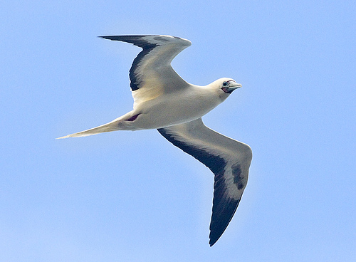
Lone boobie flying with the canoe at sea
July 9
The navigators continue to tack east to look for the Marquesas. They tacked north at sunset last night, then south at sunrise this morning. Current heading was Haka Malanai (S by E)/Hema (S), at 5 knots. The Hokule'a made back about 70 miles of easting toward the Marquesas since yesterday morning.
Winds are from 'Aina Malanai (ESE) at 10-15 knots; seas are moderate with two swells running close together, 'Aina Malanai (ESE) at 6-8 ft, and La Malanai (E by S) at 3-4 feet. Tacking into wind and swells has made the canoe ride wet with seaspray over the bow, but the crew is in high spirits.
Fishing report: caught a mahimahi at 6:15 p.m. last evening.
Sea Life: Boobies and Koa'e Kea (White-tailed tropic birds), which nest in the sea cliffs of the Marquesas Islands. Both birds can stay at seas for days, so the direction of their flight is not useful for finding land.
July 10
Hokule'a was heading Manu/Noio Ko'olau (NE/NE by E), at 5.5 knots this morning. They have been on this tack since yesterday afternoon. The canoe is about 78 miles WNW of Eiao, the island at the Northwest corner of the Marquesan Archipelago. Eiao is about 2000 feet high, a little lower than the island of Lana'i; on a clear day, it can be seen within 44 miles.
The navigators were watching a stationary cloud on the horizon to the ESE, wondering if this was a sign of land, but they did not sight any flocks of land-based seabirds this morning at sunrise flying in that direction.
Winds are from 'Aina Malanai (ESE) at 15 -20 knots. Two swells, one from ESE (6-8 ft.) and one from the E (10-12 ft.).
Fishing report: Caught a 7 lb. aku and a 20 lb, ono this morning.
Sea Life: Boobies. One manu-o-ku, a land based bird, this morning.
July 11
Hokule'a continues its zigzagging search pattern, looking for the Marquesas. At noon yesterday, Hokule'a changed its heading to Hema/Haka Malanai (S/S by E). They sighted three manu-o-ku (land-based seabirds) feeding. This morning at 7 a.m., Hokule'a tacked again, to Noio/Manu Ko'olau (NE by E/NE). The canoe is doing 5 knots. The crew saw small piles of birds this morning, but mainly koa'e kea (white-tailed tropic birds), not the land-based birds they are looking for.
The canoe is 90 miles due west of Nukuhiva, its destination. On its present heading and speed, the canoe will be about 20 miles WSW of Eiao at sunset today--close enough to see the island if the horizon is clear.
Eiao, the island at the Northwest corner of the Marquesan Archipelago, is about 2000 feet high, a little lower than the island of Lana'i; on a clear day, it can be seen within 44 miles.
Winds are from 'Aina Malanai (ESE) at 15 knots. Clear skies, cumulus clouds. Seas of 12-18 feet, with some white caps and steep swells, one from ESE and one from the E. The canoe is rocking and rolling on its current tack.
The crew was cleaning the deck when we called over the single-side band radio.
Sea Life: Manu-o-ku, koa'e kea (white-tailed tropic birds).
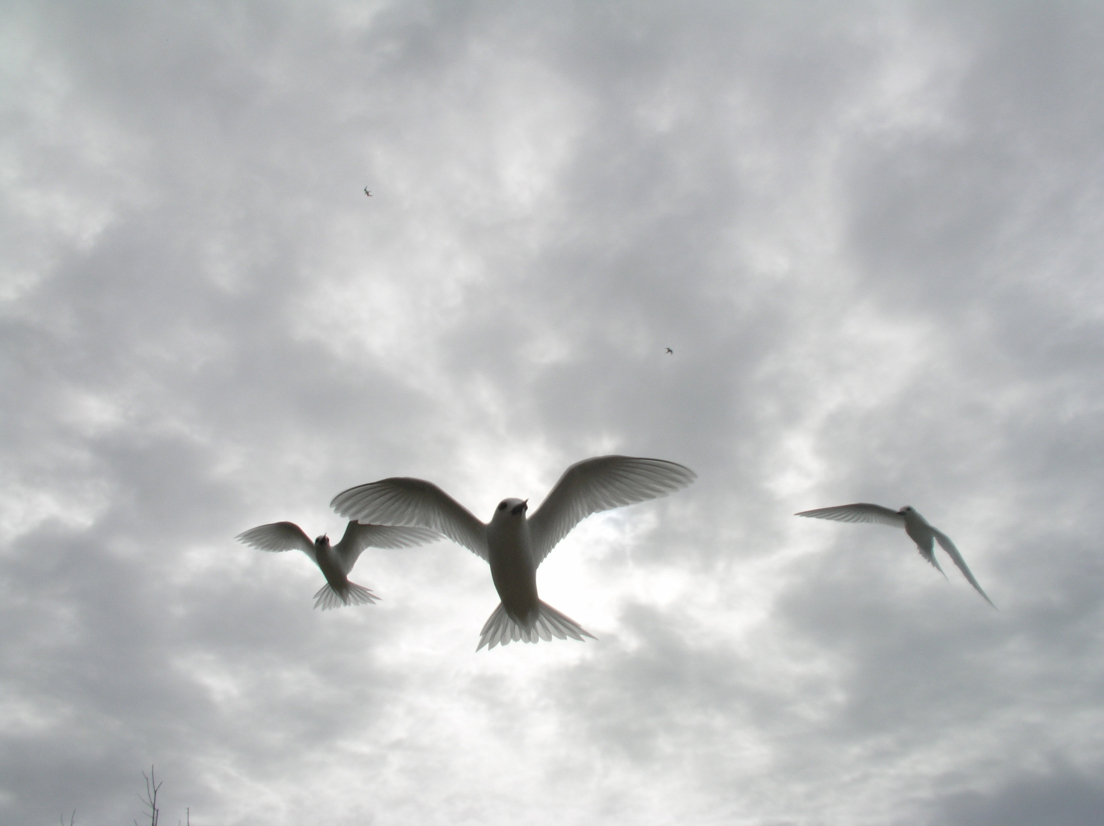
Manu-o-Ku, land based sea birds.
July 12: Sighting Eiao
Last night at around 2 a.m, heading Manu Ko'olau (NE), the navigators sensed something was changing in the wave pattern. They thought they might be passing an island and put down the sails and stopped. Rain squalls started up, sweeping in with the ESE tradewinds. The canoe was straight upwind (WNW) of the islands of Eiao and Hatutu, 11 miles off; the islands were blocking the ESE trade wind swell. The canoe started to drift. Dawn came and they couldn't see the islands in the curtains of rain. But as the squalls moved off, Russell Amimoto sighted the edge of Eiao, an island of steep cliffs, 14 miles off.
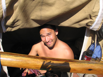
Russell Amimoto
The sea was full of diving and fishing land-based seabirds the crew had been hoping to see for the last two days: manu-o-ku (white terns) and noio (brown terns), along with boobies.
The canoe is tacking south and heading around Eiao for Nukuhiva, 60 miles off. The wind is from 'Aina malanai (ESE) at 15-20 knots; seas are choppy, with various wave patterns created by the 12-18 foot swells wrapping around the seven islands of the Marquesas to the SE. Weather continues to be squally, and swells were crashing over the bows.
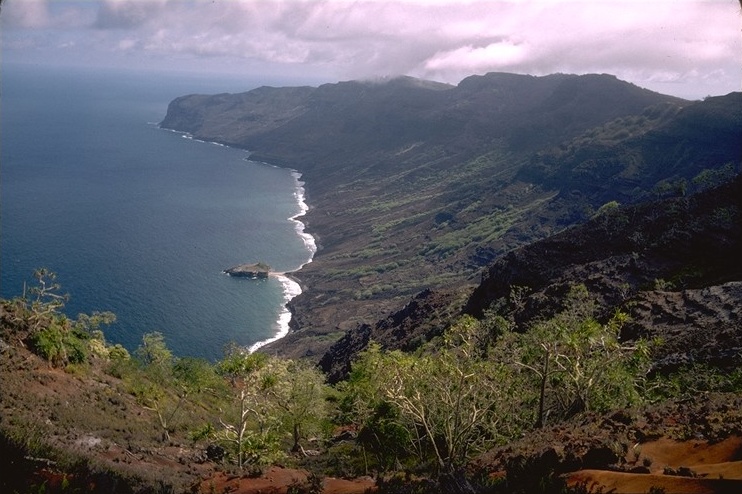
Southern coast of Eiao, Marquesas islands. Photo by Stéphane Jourdan Quadrada©.
It was an awesome tack back into the teeth of the easterly trade winds, for four days, from 200 miles to the west of the Marquesas. The navigators employed a search pattern along a known latitude that is part of the traditional strategy for wayfinding without instruments and finding islands in the immense empty spaces of the Pacific Ocean; and that strategy has been successful again!
Late yesterday afternoon, just before cooking dinner the crew was visited by some whales and dolphins, good luck signs for sailors. Instead of the usual music and mo'olelo (storytelling) over the last two nights, the crew has been looking for land.
Sea Life: whales, dolphins, manu-o-ku, noio, 'a (boobies).'
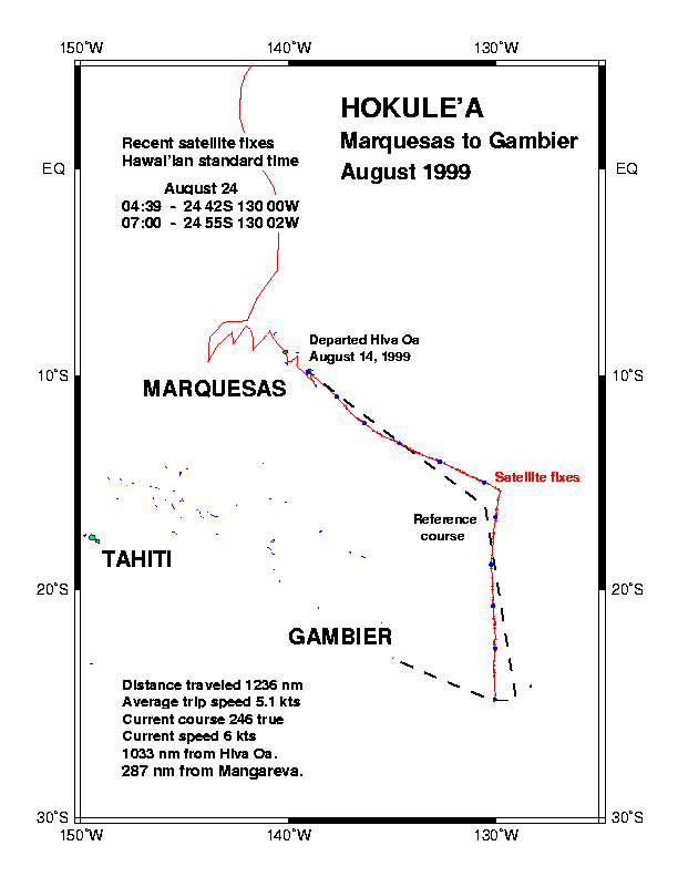
Satellite track shows Hokule‘a turning west, then tacking back east, sarching for islands along 9 degrees S.
July 13
Heading Manu Ko'olau (NE) at 5 knots. Seas diminished in the shadow of Nukuhiva, Ua Huka and Ua Pou. Light easterly winds, 10-15 knots. Cumulus clouds. The crew is cleaning up the canoe and then plans to relax and enjoy the day. 4-5 hours out from Taiohae, the administrative center of the Marquesas, and the main harbor on Nukuhiva.
Fishing report: 15 lb. Ahi
Sea Life: dolphins this morning, boobies and other birds.
July 14
The first greeting from the Marquesas were from porpoises at the bows of both the escort boat and canoe, and by fishermen from Nukuhiva who gave the canoe and the escort boat one ahi each.
