Plan for the Voyage to Rapanui
Nainoa Thompson
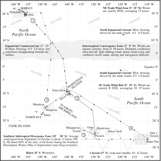
On our voyage to Rapa Nui, we are going to make five legs, change the crew five times.

Near the equator is an area called the Intertropical Convergence Zone. The Doldrum area. Very cloudy. Going to Tahiti we just sail down there as close to the wind as we can. And this is a problem. But on the voyage to Rapa Nui we are going to Nuku Hiva so, we have to go this more distance upwind (to the east) to the Marquesas and this more distance upwind to the island of Mangareva. The reason that we have not yet made the voyage to Rapa Nui is not that we didn't want to, but we didn't know how. We have to go 1400 miles directly into the wind. Going downwind would take us about 12 days or so. Multiply that by five (because of tacking) and now you are up to sixty days. How in the world could our ancestors have done this? We are going to the land of the people who I think were - if we assume that the colonizers of the largest nation on earth were the greatest explorers of all time - this particular leg had to be the most difficult one of them all. I go there in great honor of the people who found this place.
To go up wind we have to tack and it takes about five times more time to get upwind than it does to get downwind. You got to know your crew. What can they do? What can they not do? How much can you push them? What is the edge of human endurance? These voyages are not easy trips We have to get Hokule'a to sail closer to the wind than it normally does. In drydock we reduced the weight of the canoe by about 4000 pounds. She's lighter, will sail harder into the wind.
Going down to the Marquesas. This is a navigator's nightmare here (in the doldrums). We have always tried to exit this as fast as we can but now he is going to have to stay in there - whatever it takes - to get up (into the wind) that distance to the Marquesas. It's not an easy task. Then tack down to the Marquesas and change the crew. Then on to Mangareva - we have got to get this easting again, maybe two hundred miles, not too bad, probably take us five days. Then we tack down to Mangareva and avoid this shield of very dangerous atolls (Tuamotus). Then we are going to change the crew again and begin this next trip to Rapa Nui. Let me put it this way, if you mathematically figured it out, if you took the canoe's performance and factored in the wind conditions, the probability of getting there is near zero if you just try to tack it. So we are going to make this incredibly complicated voyage. We are going to take the smallest crew ever. We are going to cut our food rations in half. We are going to cut our water rations in half. We would ordinarily take 400 gallons on this trip but we are going to take 210. Just to cut the weight down. We will depend on catching rain. Increase speed, go higher into the wind. We get to Pitcairn and will go into Bounty Bay - if we can anchor. But if the wind is in the wrong direction it is not a safe anchorage.
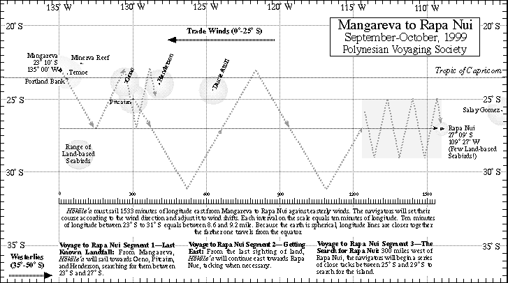
Depending on the wind conditions, we have two strategies. One is to try and tack it against the southeast trade winds and we would need to get some very favorable wind shifts in order to do that. But this is a long brutal job. Going into the weather all the time. It's rough on the canoe. It's wet. The other choice is to get to Pitcairn and go south. Go south of the trade wind belt and get through what they call the horse latitudes into the counterpart of the trade winds some place below thirty (degrees south) where the winds shift westerly so now the winds will be coming behind us. So our idea is to take about 6 to 8 days to get through the horse latitudes and sail across here five hundred miles and then tack back up north. [The second strategy was later abandoned as too dangerous, as the westerlies below 30 degrees south are generated by winter storms that could overwhelm the canoe.]
Now, what is so fascinating about Rapa Nui to me is that it is smaller than Ni'ihau, lower than Ni'ihau. How in the world did our ancestors do it? They were the greatest navigators of all time. Sailing across there (down low around 35 degrees south) you can imagine that being able to judge speed and time is critical. We want to come up to a point that is the distance equal to that between the big island and Niihau?. We know the Hawai'ian Islands. We have a feel for that distance. We want to compact? them and make sure that we didn't sail past that island. And then set up a series of tacks using the stars to tell latitude and tack enough so that we will cross this whole ocean area in a search pattern.
Again, there are four parts of this, one to get to Pitcairn- to get as close as we can to Rapa Nui from a known spot that we will leave from. So at Pitcairn we can forget all that we have memorized up to then, tack south, get into the westerlies, sail east, turn up (north), and get to a point one Hawaiian Island chain distance from our target and then search. We think it will take a long time. I don't even want to predict how long it will take. But it is going to be quite a challenge.

The two biggest issues that we have never dealt with are sailing into the wind for such a long time and the tiny target that we are trying to hit which will force us to employ a search strategy that we have never used before. As we sail west it is important to know when to turn, if we turn too soon we will end up tacking into the wind and it will take too long, if too far, we will be sailing toward South America.
See “Winds, Weather, and Currents of the Pacific” for a description of the weather zones through which Hokule‘a would sail to reach Rapanui.
