
1999 Voyage to Rapanui
Exploring the Night Sky: How to Find the Navigation Stars
On the voyage to Rapanui (September-October 1999), navigators on board Hokule'a presented via their single-side band radio Na Hoku Ho'okele / "The Navigation Stars" about the sky and wayfinding, on Hawaiian KINE 105.1 FM. The broadcasts took place once a week in the evening after sunset.
On the Voyage Home (Tahiti to Hawai'i, January 2000), the broadcasts took place in the early morning before dawn as well as in the evening after sunset. Star observations were at home, or at designated sites, with the assistance of students of navigation.
The following activity, along with the radio broadcasts, allowed participants to explore the night sky and increase their understanding of how non-instrument navigation is done. A star compass and star maps were provided to help listeners find the stars and other celestial bodies mentioned in the radio broadcast as well as understand the navigation information in the daily reports from the canoe, published on the PVS website.
Objectives:
- Identify Cardinal Directions
- Identify Major Stars and Constellation Used in Wayfmding
- Identify Stars that can be Used to Determine Latitude
Before the broadcasts, participants did the following:
1. Select an observation site with as clear a view of the circle of the horizon and night sky as possible. The dimmer the lights of an area at night, the better it is for viewing.
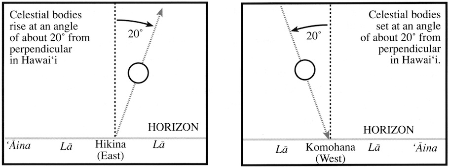
2. Determine the four main directions (East, West, North, South) at your observation place. This can be done at sunrise or sunset, or at night. East (Hikina) is toward the rising sun; West (Komohana) is toward the setting sun. Remember that in October the sun is rising one house (11.25°) south of East and setting one house south of West. (See the Star Compass for an explanation of houses and the Hawaiian names for the houses and their English equivalents.) In January, the sun is rising two houses (22.5°) south of East and setting two houses south of West. (One or two hand spans along the horizon, with your arm outstretched, may give you 10 or 20 degrees, depending on the size of your hand; each hand differs. The circle of the horizon is divided into 32 houses of 11.25°, or 360° in all.)
Also remember that in Hawai'i, the sun rises at an angle of 20° toward the south from a line perpendicular to the horizon, so you should make your observation as close to sunrise as possible before the sun angles away from its rising point on the horizon. West is directly opposite of East on the horizon. Check your sense of West by watching where the sun sets. The sun is setting from an angle of 20° to the south of a line perpendicular to the horizon.
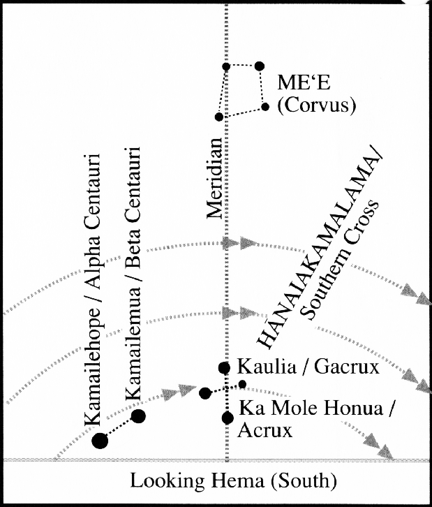
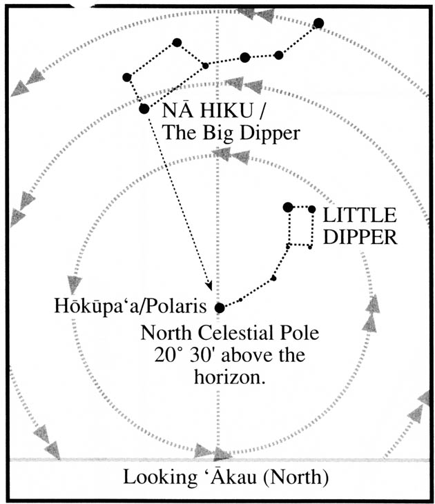
North ('Akau) is 90° away from E and W, directly to the right ('akau) of you when you are facing west; South (Hema) is on the opposite side of the horizon from north, 90° away from E and W, directly to the left (hema) of you when you are facing west. If you were the sun traveling across the sky from East to West, North would be on your right hand side and South on your left. Hence the Hawaiian names for North (right) and South (left). In Hawai'i, Hokupa'a, or Polaris, is stationary directly above due north. Hanaiakamalama, or the Southern Cross, points due south when it is upright.
You may use features of the landscape (like mountain peaks) or buildings to mark the four cardinal directions.
3. Other terms that will help you find celestial bodies in the night sky: The point directly above your head is called the Zenith. An imaginary line that goes from North to South and passes through the Zenith is called the Meridian, which divides the sky in half. The half toward the east is called the Eastern Sky; the half toward the west is called the Western Sky. A celestial body toward East in the evening will appear to travel up the eastern sky to the meridian around midnight, then continue down the western sky and set in the early morning hours.
The North Celestial Pole (NCP) is the end point of an axis around which the sky appears to be turning. The altitude of the NCP above the horizon in the Northern Hemisphere is equal to the latitude of the observer. Thus, NCP appears due north, about 20.5° above the horizon at 20.5° N latitude (the mid-latitude of Hawai'i). Hokupa'a, or Polaris, is very close to the NCP. In Hawai'i, stars around the NCP appear to circle slowly around it, counterclockwise. These stars are called circumpolar. (Actually, the earth is rotating, rather than the sky.)
The South Celestial Pole (SCP) is the other end of the axis around which the sky appears to be turning. The SCP is 20.5° below the horizon at the latitude of Hawai'i (20.5° N), and the stars circling around it clockwise cannot be seen. However, these stars are visible at the latitude of Rapa Nui (at 27° S), where the SCP appears 27° above the horizon and the NCP is 27° below the horizon.
As you listen to navigators talk about navigation and the night sky, you may wish to be outside, or go outside later, to your observation site to identify the celestial bodies mentioned in the broadcast. The navigators will refer to these points and lines at the horizon or in the sky to help you find stars: East, West, North, South, Zenith, Meridian, Eastern Sky, Western Sky, North Celestial Pole, and South Celestial Pole.