 |
|
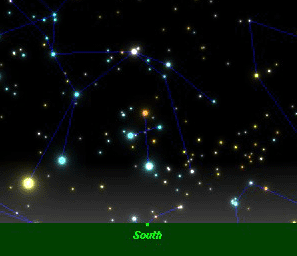
How the Wayfinder Determines Latitude Illustration below: The Southern Crux as it Crosses the Meridian is a Clue to Latitude. Latitude-Height of Stars Crossing the Meridian
One strategy of locating an island without navigational instruments is called lattitude sailing. It involves sailing to the latitude of an island, preferrably upwind, then searching for the island along that latitude. For this strategy to work, the navigator must be able to tell when he is at the latitude of the island. The navigator can make a rough estimate from his dead reckoning, but there are more precise methods to determine latitude without instruments. The North Star / Hokupa'a North of the equator, the altitude of the relatively fixed star Hokupa'a (Polaris, the North Star) is approximately equal to the latitude of the observer. (Hokupa'a is actually 44' from the celestial north pole and inscribes a 1.5° circle around it.) The altitude of the star can be measured using the hand stretched out in front of the eyes, with shoulders squared. Different configurations of the hand ( e.g., a fist, a span, two fingers, three fingers, etc.) can be calibrated to distances (degrees) in the sky. Meridian Pairs Stars crossing the meridian can also be used to estimate latitude. At given latitudes, a star crosses the meridian at a certain altitude. If the navigator knows the altitude of the meridian crossing of a star at a particular latitude, and he can tell when the star is crossing the meridian, he can estimate his latitude by measuring the altitude with his hand. To know when a star is crossing the meridian, the navigator uses meridian pairs--stars which cross the meridian togther. When the pair is perpendicular to the horizon, the stars are crossing the meridian. (The meridian is an imaginary line on the celestial sphere passing through the north and south celestial poles and the zenith, the point directly above the observer's head. The closer a star is to the horizon, the more accurately its altitude can be measured without instruments. However, stars that cross the meridian too close to the horizon, 1-3 ° from it, often cannot be seen because of clouds, dust, sea spray, etc.) At the equator, the altitude of a star as it crosses the meridian is equal to 90 ° minus the star's declination. (The declination of a star gives the position of a star on the celestial sphere, measured in degrees away from the celestial equator, an imaginary circle that passes through due east and due west.
(The declinations of stars are published in astronomical handbooks.) The Southern Cross / Hanaiakamalama: One meridian pair is the top and bottom stars in the Southern Cross, Gacrux (Kaulia) and Acrux (Ka Mole Honua).
As the observer moves north of the equator, these two stars will cross the meridian at lower and lower altitudes above the south celestial pole; the observer can substact his latitude from the altitude of the star crossing the meridian at the equator to get the altitude at which the star crosses the meridian at his new latitude.
As the observer moves south of the equator, the two stars in the Southern Cross would cross the meridian at a higher and higher altitude; the observer adds his latitude south of the equator to the altitude of the star crossing the meridian at the equator to get the altitude at which the star crosses the meridian at his new latitude.
Click here for a Diagram of the Southern Cross at the Meridian in Hawai'i. The fact that the distance between Ka Mole Honua and the horizon, and Kaulia and Ka Mole Honua are equal (6 °) is an additional clue to the latitude of Hawai'i. As the sun passes through the zodiac over the course of the year, the stars in the portion of the sky in which the sun is located are not visible. So those stars would not be available for determining latitude at that time of the year. The navigator uses meridian pairs that are visible after sunset and before dawn at the time of the voyage. Voyages are planned for times of the year when the weather and winds are optimum and also when certain meridian pairs are visible. For example, when sailing to Hawai'i from the South Pacific, the navigator wants to have the Southern Cross crossing the meridian in the night sky for determining when the canoe has reached the latitude of Hawai'i. Click here for lists and diagrams of meridian pairs used during the voyage to Rapanui (1999-2000). The Southern Cross was visible crossing the meridian in the predawn sky as Hokule'a returned to Hawai'i in February, 2000. Latitude-Rising and Setting Pairs Pairs of stars that rise or set at the same time can also be clues to latitude. Pairs rise and set together only at specific latitudes. For example, when 'A'a (Sirius) and Nana-hope (Pollux) set together, the observer is at the latitude of Tahiti, or 17 ° S. As the observer moves north or south of that latitude, one or the other star will begin to rise or set before or after the other star. It is easier to use setting rather than rising pairs of stars to determine latitude, because the observer can watch the pair as it approaches the horizon instead of trying to anticipate their appearance. Zenith Stars At a given latitude, only certain stars will pass through the zenith, the imaginary point in the sky directly overhead. The most conspicuous (i.e. brightest) of these stars is called the zenith star of that latitude. The zenith star of Hawai'i is Hokule'a (Arcturus); the zenith star of Tahiti is 'A'a (Sirius). The declination of the zenith star is equal to the latitude it is associated with. Thus the declination of Hokule'a (Arcturus) is 19 ° N; the latitude of South Point on the Big Island of Hawai'i is about 19 ° N; the declination of 'A'a (Sirius) is 17 ° S; the latitude of Tahiti is 17 ° S. If the navigator knows the zenith stars of different latitudes, he can tell what latitude he is at by observing what star passes directly overhead at night. However, while the observer can make a rough estimate, it is difficult to tell when a star is passing directly overhead on a canoe that is pitching, rolling, or corkscrewing along. The observation is not as precise for determining altitude as the other methods: (1) measuring altitude of Hokupa'a north of the equator; (2) measuring the altitude of stars as they cross the meridian; or (3) watching for pairs of stars that rise or set together. |
 Latitude is the distance on the earth's surface from the equator. It is given in degrees north or south of the equator (One degree of latitude equals 60 nautical miles; each degree contains sixty minutes; one latitude minute equals one nautical mile.)
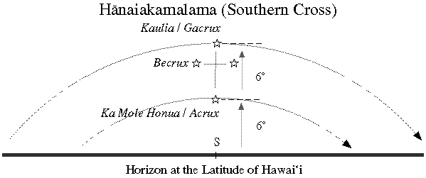