 |
|
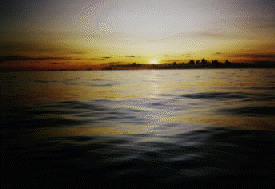
Modern Wayfinding: Course Strategy and Departure Time [Photo Below: A Voyage from Hawai'i to Tahiti Takes the Canoe Across the Doldrums]
Hawai'i to Tahiti A course strategy can be illustrated using a Hokule'a voyage to Tahiti as an example. The best time to sail to Tahiti is in the late spring or early summer-in between the storm seasons and the hurricane seasons north and south of the equator in a typical year. Sailing to Tahiti is a challenge because Tahiti lies to the south southeast of Hawai'i, upwind and upcurrent, so the canoe must sail east into the wind and current for most of the way. The canoe crosses the NE and SE tradewind zones as well as two great west- flowing ocean currents-the north and south equatorial currents, which can carry the canoe 14-20 miles westward per day. On the 1992 voyage to Tahiti, Hokule'a's reference course line ran SE by S, sailing on a close reach, full and by the wind, until about 9 degrees N latitude or 700 miles from Hawai'i. This course line represents the course the canoe would sail to get to Tahiti under average wind conditions, given the sailing capabilities of the canoe. However, wind conditions are never average, and the canoe deviates from this reference course, sailing in whatever direction the winds allow it to sail, and the wayfinder modifies his course accordingly. The objective of the wayfinder is not to stay on his reference course, but to get to his destination. At about 9 degrees N, the canoe enters an area called the Intertropical Convergence Zone (ITCZ), which lies between the NE and SE trade wind systems (and the west flowing north and south equatorial currents). This region, where the NE and SE trade winds converge, is noted for its heavycloud cover, squalls, light and variable winds, and dead calms, all of which make sailing and navigating less than ideal. The windless weather, a condition known as the doldrums, could stall the canoe for days. The heavy cloud cover hides the stars, so navigating by the celestial bodies is difficult. Under such conditions, the wayfinder uses the ocean swells to orient the canoe. However, confused seas in the area, without clear swell patterns, may make steering by the swells difficult as well. The days of calm and heavy cloud-cover test the patience and intuition of the wayfinder, but the doldrums have a unique beauty: on days when sunlight is diffused in the heavy cloud cover, the sea mirrors the golden light; on clear nights, the sea surface can be so smooth that the stars and constellations are reflected in it; on nights of 100 percent cloud cover, the ocean and sky are pitch black. In the ITCZ, between the two west-flowing equatorial currents, is the eastflowing equatorial countercurrent, which results from the water pushed west by the tradewinds flowing back east parallel to the equator. This countercurrent could help the canoe gain easting. However, the countercurrent is sporadic and shifting. It is generally weakest in MayJune and strongest in September- November, when its speed can reach about 1 knot. Occasionally the countercurrent becomes stronger, as it has in 1992, because of El Ni?o, a weather condition which brings westerly winds to the Southern Pacific and dangerous hurricanes. During the last major occurrence of El Nino, in 1982-1983, Tahiti was hit by six hurricanes. The canoe tries to get out of the ITCZ as quickly as possible, sailing SSE in the shifting winds. Once the canoe is in the south east trade wind zone, at about 3 degrees N, the strategy is to sail south against the E to ESE winds, without losing any easting, until the canoe reaches one of the islands in the target screen, which stretches 400 miles E to W from Manihi in the Tuamotus to Maupiti in the Society Islands. If the canoe has enough easting, it will make landfall east of Tahiti and it can head downwind (SW) to to its destinatio (Adapted from Will Kyselka's Ocean in Mind. Honolulu: UH Press, 1985.) Rarotonga to Hawai'i-1992 Course Strategy Designer: Nainoa Thompson, Sailmaster of the Hokule'a Starting Point: Rarotonga in the Cook Islands (21 degrees 14 minutes S latitude; 159 degrees 46 minutes W longitude) Target Screen: The Hawaiian Islands, between 18 degrees 30 min. N latitude (25 miles south of Ka Lae, or South Point) and 22 degrees 30 min. N latitude (16 miles north of Kaua'i), or 240 miles S to N; and between 154 degrees 40 min. W longitude (25 miles east of Cape Kumukahi) and 160 degrees 20 min. W longitude (Ni'ihau), or 340 miles E to W. Destination: Hilo, Hawai'i Estimated Length of Voyage: 2,749 miles; about 26 days. Sailing Plan
2. N by W at 2.5 knots through the doldrums (3 degrees N to 9 degrees N) 3. N by W at 5 knots to 20.5 degrees N latitude, arriving about 85 miles east of the Hawaiian Islands. 4. W at 5 knots until one of the Hawaiian Islands is sighted. Segment 1: In the Southeast Trades
Average Wind Conditions: Southeast trades, from E to ESE at 10 to 20 knots. Current: South Equatorial Current; west-flowing; 0.5 knots; 12 miles per day (0.5 knots x 24 hours) Average Canoe Speed: 5 knots; 120 miles per day (5 knots x 24 hours); Heading: NNE; Actual heading with current factored in: between NNE and N by E Total Distance to be Travelled: 1,572 miles (Pre-voyage estimate); Total Time: 13.1 days (1572 miles at 120 miles per day)
Average Wind Conditions: Variable; generally out of the east; 0 to 10 knots Current: Equatorial Countercurrent; east-flowing, but unpredictable Average Canoe Performance: 2.5 knots; 60 miles per day (2.5 x 24 hours); Heading: NNE; Actual heading: NNE (No compensation for current drift. While the Equatorial Countercurrent runs east in this area, it is unpredictable and may or may not take the canoe eastward. However, if the countercurrent is flowing, it will benefit the canoe by helping it to get east of its target of Hawai'i. And if the canoe is in the doldrums for a great length of time, the wayfinder may have to take this east-flowing current into account and reestablish the position of the canoe farther east of the position estimated without compensating for the current.) Total Distance to be Travelled: 390 miles (Pre-voyage estimate); Total Time: 6.5 days (390 miles - 60 miles per day)
Average Wind Conditions: NE Trades, generally from NE by E; 10 to 20 knots Current : North Equatorial Current; west-flowing; 0.5 knots; 12 miles per day (0.5 knots x 24 hours) Average Canoe Performance: 5 knots; 120 miles per day (5 knots x 24 hours); Heading: N by W; Actual heading with current factored in: between N by W and NNW Total Distance to be Travelled: 702 miles (Pre-voyage estimate); Total Time: 5.85 days (702 - 120 miles per day)
Average Wind Conditions: NE Trades, generally from Noio Ko'olau (NE by E); 10 to 20 knots Current: North Equatorial Current; West-flowing; 0.5 knots; 12 miles per day (0.5 knots x 24 hours) Average Canoe Performance: 5 knots; 120 miles per day; Heading: W; Actual performance with current factored in:132 miles per day Total Distance to be Travelled: 85 miles (Pre-voyage estimate); Total Time: 0.7 days The departure date of October 20 from Rarotonga was determined by two factors. First, to avoid the winter storm seasons in the southern and northern hemispheres. October is ideal because it is in-between the southern hemisphere winter (June-September) and the northern hemisphere winter (December-March) when the probability of encountering storms is greater than at other times of the year. October also falls between the hurricane season in the northern hemisphere (June-September) and the hurricane season in the southern hemisphere (December- February). Another important factor in setting a departure date is the moon phases during the voyage. The voyage is timed so that there is moonlight at strategic points. A bright moon is desirable while the canoe is in doldrum conditions (around 3 degrees N to 9 degrees N), so the wayfinder can see the ocean swells at night when heavy cloud cover is hiding the canoeguiding stars. An experienced wayfinder can steer by maintaining a consistent pitch and roll in the movement of the canoe; but seeing the swells is an added clue in maintaining his direction. Moonlight is also important as the canoe approaches Hawai'i because the wayfinder will use the altitude of stars above the horizon to determine his latitude; on cloudy nights with little or no moonlight, the horizon line cannot be seen; moonlight renders the horirzon visible. The voyage from 1992 voyage from Rarotonga to Hawai'i was planned so that the canoe would have a waxing (increasing) quarter moon as it reached the doldrums (approximately Nov. 3) and a waxing crescent moon as it approached Hawai'i (around Nov. 24).
1. the canoe and crew have been properly prepared; 2. the weather is right, based on (a) meteorological reports (no major storms are headed for the course) and (b) observations of wind direction and speed, the shapes of clouds, and the color of the sky at the horizon at sunrise to determine that good sailing weather would hold for a couple of days. When the canoe sails out of Rarotonga on a NNE course, the wayfinder is aware of islands along the way, on which he will want to avoid running aground in the dark. Manuae (Hervey Island) is only 15 miles east of the course at 19 degrees 21 minutes S and Aitutaki is 42 miles west of the course at 18 degrees 54 minutes S. The canoe will leave early enough in the day to pass these islands during daylight. As the canoe continues NNE, it will pass on its port side:
Rakahanga - 10 degrees S Penrhyn - 9 degrees S Starbuck - 5 degrees 37 min. S Malden - 4 degrees 03 min. S Kiritimati (Christmas) - 1 degree 52 min. N And on its starboard side: Flint - 11 degrees 26 min. S The Turn West As Hokule'a approaches the latitude of Hawai'i upwind from the islands (i.e., to the east of it, as his course strategy requires), the wayfinder has to make a major course decision: when to turn the canoe downwind, west toward Hawai'i. Ideally, this turn should be made at 20.5 degrees N (the latitude of the midpoint of the S to N target screen between the Big Island and Kaua'i). The wayfinder determines his latitude by the altitude of Polaris and by the altitude of stars as they cross the meridan. (See "How the Wayfinder Determines Latitude") Landfall The manu-a-Ku (fairy tern) and the noio (noddy tern) will help to expand landfall, indicating the presence of the islands before any island can actually be seen. When the canoe crew sights and identifies any one of the Hawaiian islands, the wayfinder will know exactly where the canoe is and head toward Hilo. Given clear atmospheric conditions, the high dome of Mauna Kea, about 14,000 feet in elevation, can be seen from over 100 miles away; when the dome is obscured by clouds or volcanic haze, visibility is reduced to about 20 miles. If the canoe approaches the Big Island from the SE at night, the first sign of land may be the glow of volcanic activity in Puna. The Reference Course The reference course represents the course the canoe would sail given average wind and current conditions and the canoe's performance capabilities. It is highly unlikely that the canoe will stay on the reference course because wind direction will vary along the way, and the canoe can only sail in the direction the wind allows it to sail. The art of wayfinding involves adapting to variable and unexpected conditions of wind and weather while maintaining progress towards the windward side of the targeted islands. The reference course is used as a local longitude line between the starting point and destination. The wayfinder can plot his position east or west of the line as the voyage progresses. If the wind pushes the canoe off the reference course, the canoe will eventually try to get back to it, or close to it, when the wind allows the canoe to do so. The wayfinder's reports of his position east or west of the reference course are estimates based on his estimates of the following:
2. the speed and direction of ocean currents 3. latitude (based on measurements of the altitudes of stars crossing the meridian) But wayfinding doesn't require exact positions to be successful. The wayfinder will be successful if he is able to
--guide the canoe to the general vicinity of his destination --locate land in that vicinity and use known landmarks to get to his destination Within the limitations of the wayfinder's estimates, these three things are possible, as the success of Hokule'a in making landfalls in the past has proven. During the actual 1992 voyage, the wayfinders modified the sail plan from the beginning. Instead of leaving October 20, they waited for winds that would allow them to go east. Southerly winds came on October 26; instead of heading NNE, the canoe took advantage of the winds and headed E to Tahiti, arriving in Pape'ete on November 1. The canoe again waited for the right winds, and on November 5 left for Hawai'i, heading N by E. Instead of taking just 26 days, the voyage took 35 days (including the 4 day stop in Pape'ete). The crew saw the lights of Hilo town and the beacon from the lighthouse at Kumukahi on the night of November 29; they sighted the Hamakua coast of the Big Island on the morning of November 30. Nukuhiva to Hawai'i Question: What course will Hokule'a sail from Nuku Hiva to Hawai'i? Preliminary Considerations-What month, time of the month, and time of the day would you depart? Given the average winds and currents,what course would you sail to Hawai'i? From which direction would you approach your destination? How far might the currents carry you east or west as you head north? How wide is the target screen (from Ni'ihau to Hawai'i)? Draw a box around the target on a nautical chart or map and give the N-S, E-W dimensions of the target. How far north or south of the islands could you be and still see them? How far east or west could you be and still see them? Formula for the range for sighting land: Square root of h + square root of H = the distance in miles from which an object can be seen; h = height of observer in feet; H = height of object in feet. The deck of Hokule'a is about 4 feet high. Givens -Position of islands (on Nautical Chart 526, if available)
Intertropical Convergence Zone (3 degrees N Latitude to 9 degrees N Latitude): Average Winds: Doldrum conditions; light and variable, averaging 7.5 knots from the East; Average Current: Unpredictable; cannot be factored into your course line. Northeast Tradewind Zone (9 degrees N Latitude to the Latitude of Hawai'i): Average Wind Speed: 15 knots from the ENE; Average Current Speed: West-Flowing at 0.5 knots. Supplementary Questions Length of Trip: Using your course line and assuming average wind conditions, how many days will it take you to sail to Hawai'i? How many miles would you travel? Capacity: Given the carrying capacity of the canoe 5.5 tons (11,000 pounds), how many people would you take? How many gallons of water? How much food? Assume: The food supplies needed per day for each crew member will weigh 5 pounds; he or she will consume a gallon of water a day; water weighs 8.6 pounds per gallon; each crew member will be allowed to take 20 pounds of personal gear. The equipment on board the canoe will weigh about 2.5 tons. (Equipment includes electrical and communication equipment, safety gear, anchors, various sizes of sails and extra ropes and lines, galley and cooking utensils, and tools.) At the end of the exercise have the participants compare their course lines, estimates of the time and distance of the trip, number of crew members, and amount of food and water they plan to carry. Questions for Open Discussion 1. What would you take for survival at sea and why? 2. Who would you take and why? |
 Before a voyage by sail begins, the wayfinder designs an ideal course for reaching the destination from the starting point, given the capabilities of the vessel and the winds, currents, and weather conditions anticipated along the way. The course should represent the most efficient way of getting to the destination, given all the factors listed above. The wayfinder must also choose the right time to go (when the wind and weather conditions are the most favorable), taking into account the timing of the return voyage as well.