 |
|
VOYAGING AND ISOLATION IN RAPA NUI PREHISTORY Ben Finney, Ph.D., University of Hawai'i, Manoa
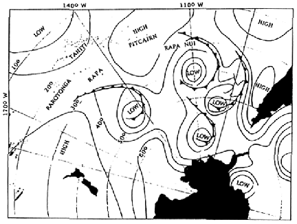
The trend of Pacific Island settlement has been eastwards. Some 50,000 years ago when vast quantities of water locked in the glaciers greatly lowered sea levels, early seafarers--probably traveling by raft--crossed the narrowed channels from Sunda, the extension of mainland Southeast Asia that most of Indonesia had become, to Sahul, a great continent formed by New Guinea, Australia and surrounding continental shelves. Around 1,500 B.C., well after the glaciers had receded and sea levels had risen, canoe voyagers with roots in Southeast Asia pushed eastwards from islands off the north shore of New Guinea, and moved rapidly through island Melanesia to reach the mid-Pacific archipelagos of Fiji, Tonga and Samoa. Their identifiably Polynesian descendants then spread farther eastwards, reaching all the way to Rapa Nui perhaps as early as 400 A.D. A solution to the puzzle of why Polynesia should have been settled by the descendants of seafarers who began on the faraway Asian side of the Pacific, rather than by voyagers from the much closer shores of South America, presents itself if we study the map of the Pacific (Keegan and Diamond 1987). Thousands of miles of open ocean lie between South America and Polynesia, a vast expanse of blue water broken only by the Galapagos and a few other islands immediately offshore South America. In contrast, the seas between Polynesia and the south-eastern end of Asia are filled with islands, beginning with the rich island world of the Philippines, Indonesia and New Guinea where the seagoing canoe and deep-sea navigational skills were apparently developed, and extending across Melanesia and Micronesia to that vast island realm so aptly named Polynesia. Whereas this vi r t u a II y continuous distribution of islands extending eastward evidently encouraged generations of canoe voyagers to sail farther and farther into the ocean by rewarding them with island after island to colonize, the empty seas off South America apparently offered little inducement for continental sailors, despite their fine sailing rafts, to cross thousands of miles of open ocean to explore and colonize an island world that was beyond their experience. Otherwise, the inhabitants of Rapa Nui and other islands of Polynesia would be speaking languages derived from the American side of the Pacific, not, as is the case, from Asian side. Yet, however logical such reasoning might seem, it does not answer the question of how the lone island of Rapa Nui, located so far to the east of the easternmost archipelagos of Polynesia, came to be settled. A canoe sailing directly to Rapa Nui from the Marquesas, thought by some to have been the source of Rapa Nui migrants, would have to cross almost 2,000 miles of open ocean. At 1,450 miles away, Mangareva, another candidate as a source island, is somewhat closer. A scattering of atolls and the tiny high island of Pitcairn lying to the east of Mangareva cuts this gap by 300 miles. But, even from Pitcairn, a voyage across 1,150 miles of open ocean to a single, small island would be a difficult undertaking. That Rapa Nui lies to windward, with respect to the easterly trade winds, of the rest of Polynesia would seem to compound this difficulty immensely. Polynesian canoes can tack to windward, but it is a long, slow process as almost four miles has to be sailed obliquely to the wind to make one mile directly to windward, a ratio that increases greatly when also sailing against a strong current (Finney 1985:10). A crossing from Pitcairn to Rapa Nui made directly against the southeast trades and accompanying currents would therefore require a canoe to sail over 4,000 miles, a task made even more difficult by the beating the canoe and crew would suffer pushing directly against wind and sea. According to such reasoning, a voyage from Pitcaim or any other Polynesian island to Rapa Nui would seem out of the question; even the colonization from the west of the main Polynesian archipelagos would look improbable because of their position to windward. Indeed, Heyerdahl (1978:332) largely based his argument against the orthodox theory of Polynesian settlement from the west on his assertion that canoe voyagers could not have sailed across the tropical Pacific against "the permanent trade winds and forceful companion currents of the enormous Southern Hemisphere." The easterly trade winds are, however, anything but permanent. Periodically they die down, and the winds blow from the west, not from the east. This monsoonal pattern is strongest in the western Pacific; in Indonesian waters the alternating seasons of winter easterlies and summer westerlies are still exploited by commercial sailing vessels to carry cargo back and forth from one end of the archipelago to another. The regular extension of these summer westerlies virtually to the edge of Polynesia was undoubtedly exploited by the immediate ancestors of the Polynesians, the makers of the famous Lapita pottery, to expand so rapidly into the central Pacific. Although these summer westerlies become much more episodic in the eastern Pacific, spells of westerly winds apparently were frequent and long-enduring enough to enable the Polynesian descendants of the Lapita pioneers to spread beyond Samoa and Tonga to the archipelagos directly to the east (Finney 1985:11-15). But once seafarers reached the easternmost of these island groups--the Marquesas, Tuamotus and Australs--they had, in effect, run out of archipelagos. Whereas for many generations members of this seafaring lineage had been rewarded with landfalls on island after island in a virtually continuous series of archipelagos that extend from Southeast Asia two-thirds out into the Pacific, any of their descendants who tried to search for yet more archipelagos farther to the east must have been sorely disappointed when they found only empty seas except for Pitcairn and its two little outliers. Furthermore, it appears that the spells of summer westerlies become even more episodic and briefer in duration the farther one sails east through these lonely seas. Indeed, the difficulties of sailing farther eastward, and the frustration of not immediately finding rich lands over the horizon, may well have played a role in those initiatives to the north-northwest and to the southwest that resulted in the discovery and colonization of Hawai'i and Aotearoa (New Zealand) respectively. Yet, despite the problems of exploring eastward, and the lack of immediate rewards for so doing, some voyagers apparently kept searching in that direction, as witness the temporary settlement of the tiny island of Pitcairn and its even more minuscule outlier of Henderson Island--and, of course, the subject of this essay: the colonization of that loneliest outpost of Polynesia, Rapa Nui. Over the last eighteen years we have sailed the reconstructed voyaging canoe Hokule'a some 40,000 nautical miles through Polynesian waters, touching on islands in Tuamotus, Societies, Cooks, Aotearoa, Tonga and Samoa, as well as throughout the Hawaiian archipelago. Although we have not yet attempted to sail to Rapa Nui, we have learned enough about the wind patterns of the Pacific, and how to use them to sail where we want to go, to hazard some educated guesses about how Polynesians might have reached this island, and, once there, what maritime links they might have had with their kinsmen to the west. In previous analyses of Polynesian voyaging and settlement I speculated on this question (Finney 1976, 1979). A brief visit to Rapa Nui in 1989, as well as by conversations with others intrigued by this question--notably, Sergio Rapu, Jo Anne Van Tilberg and Cesar Caviedes--now leads me to expand on those speculations. The key to reaching Rapa Nui would be to get enough days of favorable westerly winds to enable a canoe to sail sufficiently far to the east in order to come close enough to the island to see it, or detect it indirectly by telltale cloud formations, by the appearance of terns or other "land finding" birds, or by other signs by which island navigators use to recognize when land is near (cf. Lewis 1972:153-232). In my earlier discussions on how voyagers might have been able to get enough westerly ~wind to push as far east as Rapa Nui, I expressed some doubt that the spells of regular summer westerlies would last long enough in eastern Pacific seas, or be frequent enough there, to enable a canoe to be worked as far east as Rapa Nui. Accordingly, I suggested an alternate way to gain easting by exploiting the zone of westerlies located between about 35° and 50° South, winds that square riggers sailing from Tahiti and other points in the Pacific once used to reach the west coast of South America. That some exploring Polynesians must have discovered this westerlies zone seems likely. However, whether they ever tried to utilize them to explore eastward is, of course, open to question, as is how long they could have survived in their open canoes the cold wind and seas that can be encountered even before entering the tempestuous latitudes known as the "roaring forties". Suppose, however, that some especially adventurous voyagers did go down to around 35° South to try to run before westerlies there, and that after a week or two the cold wind and rough seas forced them to angle north to seek the warmth of the tropics. If so, they might have stumbled across Rapa Nui in their flight from the cold. Eric de Bisschop's unsuccessful attempt to use these westerlies to sail a bamboo raft from Tahiti to South America in 1956-57 (de Bisschop 1958), relates to the above scenario. De Bisschop first sailed south from Tahiti to get out of the trade wind zone, and then turned toward South America, at around 30° South, hoping to find enough westerly wind there to work eastward without having to expose his craft and the crew to the rigors of the higher latitudes. Although they found some westerly wind there, they were not far enough south and therefore had to endure long spells of easterly head winds and calms. After months of slowly working eastward, de Bisschop and his crew were finally forced to abandon their disintegrating raft--but not before they had passed a just a few hundred miles to the south of Rapa Nui. Perhaps sometime in the past a sleek double-canoe with sailing characteristics superior to that of de Bisschop's raft might have followed a similar course, but just far enough to the north to have resulted in a landfall on Rapa Nui. Since then, two, perhaps even more plausible possibilities for finding enough westerly wind to reach Rapa Nui have come to mind, one stemming from the realization that warm currents known as El Nino that periodically wreak havoc to the food chain in the waters immediately offshore Peru are part of basin-wide disturbances in oceanic and atmospheric circulation, and the other from our success in sailing Hokule'a from Samoa to Tahiti using winter westerlies rather than those occurring during the summer. Typically preceding or during an El Nino event the usual atmospheric pressure gradient across the South Pacific of high in the east and low in the west flattens out or reverses. This is known as the "Southern Oscillation"; hence total phenomenon of ocean and atmosphere disturbances is referred to as an "El Nino-Southern Oscillation" (ENSO) event, although here I will use the simpler label of El Nino event. This oscillation manifests itself in a weakening of the trade winds, and the outbreak of prolonged and intensive periods of westerlies, generally during or around the summer season. Although these westerlies are usually confined to the western and central Pacific, in 1982-83 a particularly massive El Nino event brought a prolonged outbreak of westerlies that pushed far into the eastern Pacific. Reports of these westerlies has led me to hypothesize that early voyagers from West Polynesia might have employed the widespread westerlies of such major El Nino events to expand to the Marquesas and other archipelagos of central East Polynesia, and that if these El Nino-intensified westerlies extended all the way to Rapa Nui they might have been crucial in the discovery of this easternmost outpost of Polynesia (Finney 1985:16-18). Subsequently, Caviedes and Waylen (MS 1989) have developed the latter suggestion, citing wind data gathered on Rapa Nui during the 1982-83 El Niflo event showing that prolonged spells of westerlies indeed reached the island. Among others, Bierbach and Cain (1988), interpret evidence from oral traditions and cultural and linguistic comparisons to indicate that the land from whence sailed the legendary colonizer Hotu Matua was located in the Marquesas. Yet, because this group lies so far directly downwind (with respect to the trade winds) from Rapa Nui, it is difficult to conceive of how voyagers from the Marquesas could ever have found sufficient westerly winds during a typical summer to sail far enough to the southeast to even get within range of the island. Nor, because of the relatively northerly position of the Marquesas, would voyagers from there have been ideally situated to catch of winter westerlies which, as outlined directly below, are more prevalent in the more southerly islands of Polynesia. The more widespread westerlies of a major El Nub event would therefore appear as the most likely wind regime that Marquesan voyagers could have exploited to sail southeast to Rapa Nui. When the Hawaiian navigator Nainoa Thompson was planning how to work Hokule'a from Samoa to Tahiti in 1986 he chose to sail during the winter, when the trades have a reputation for being steadiest, instead of the summer when westerlies are typically most common. He did this for two reasons: first, because he wanted to avoid sailing during the summer hurricane season, and second, because his research had shown that even during the winter there may occur spells of westerly winds favorable for sailing to the east. These winter westerlies are caused by the passage through the trade wind field of troughs that extend up from low pressure systems moving across the ocean far to the south. The winter of 1986 proved to be unusual winter season, for low pressure troughs repeatedly disrupted the trade wind field, bringing westerly wind shifts that enabled Hokule'a to sail first to the southern Cooks and then from there on to Tahiti (Finney 1988). These winter westerlies are more prominent in the seas along the southern edge of Polynesia, since these waters are closer to the low pressure systems that generate them as they cross the ocean still farther to the south. For example, during May through September the weather on Rapa Nui (270 South) is often unsettled and rainy with frequent spells of westerlies winds (British Admiralty Vol. 2:37); during the week I was there in August of 1989 westerly winds, or northerly winds which are also favorable for sailing to the east, prevailed during four of those seven days. Yachtsmen wishing to sail to Rapa Nui from the west have found these winter westerlies most useful, typically sailing from Mangareva (23° South) to Pitcairn (25° South), and then on to Rapa Nui. As Green (1988:55) and Langdon and Tryon (1983:53-55) have suggested, perhaps earlier voyagers chanced upon Rapa Nui in following this route, or in sailing a parallel route from one of the Austral Islands, which extend from Rurutu (22° South) to Rapa (27° South), or in sailing from as far west as Rarotonga (21° South) or Mangaia (22° South) in the Southern Cooks. Figure 1 shows a weather map for 8 July 1988 obtained at the Chilean meteorological office on Rapa Nui which shows the pattern of mid-latitude low pressure systems moving eastwards with troughs extending into Polynesian waters, and bringing westerly wind shifts that could be exploited to sail east toward Rapa Nui.
Fig. 1--Surface weather pattern on 8 July 1988. The two low pressure troughs extending above 30° S are bringing northerly and westerly winds favorable for sailing to the east from the southern margins of central East Polynesia to Rapa Nui. Some support for the thesis that Rapa Nui was reached by voyagers who exploited westerlies to intentionally explore to the east beyond the last known points of land comes from computer simulations in which these wind patterns are programmed. Although the original computer simulation study of Levison, Ward and Webb (1973) in which only drift voyages were simulated virtually ruled out the possibility that Rapa Nui could have been reached by drifting there from any other point in Polynesia, when Ward (MS 1988) and then Irwin, Biskler and Quirke (1990) subsequently made intentional sailing and navigation part of the computer algorithm they were able to simulate some voyages to Rapa Nui. The famous "Manuscript E", which records a Rapa Nui account of the colonization of the island (Barthel 1978), the colonizers had foreknowledge of the island and sailed directly to it. Inasmuch as knowledge of Rapa Nui was obtained by the voyage of the dream soul of Hau Maka to Rapa Nui and back the homeland, one is tempted to dismiss the account as so much fantasy. Yet, there is some ethnographic background to it. According to the journal of Edward Robarts (Dening 1974:62,119; cf. Porter 1822, Vol. 2:54-55), a British sailor who lived in the Marquesas at the beginning of the 19th century, even at that late date the shamanistic prophets (tau'a) were still having dreams of rich islands over the horizon that were inspiring groups of Marquesans to take to their canoes in search of them. Even though the computer simulation study of Levison, Ward and Webb (1973) would seem to rule out a "pure" drift voyage all the way to Rapa Nui from any other point in Polynesia, unexpected westerly gales might have played a role in the island's discovery. Marquesans sailing to the Tuamotus could have been driven far to the east by sudden westerly gales, and then have elected to keep heading in that direction in hope of finding land sooner than it would take them to work their way back to the west. Similarly, people making a crossing from Mangareva to Pitcairn, or between islands in the Austral group might have been driven far past their target by strong westerlies and then opted to keep pressing eastward. Whether the result of an intentional exploring initiative, or of a combination of unexpected westerlies and a desperate gamble to run before them, the discovery of such a lone, small, and distant island as Rapa Nui was truly an impressive achievement. Could more than one canoe have reached the island, as some traditional accounts (for example, Englert 1970:88-84 and Mulloy 1979:113) might appear to indicate? Multiple landfalls from different islands in central East Polynesia (or from the same source island, but from different time periods) are of course possible, though the odds against very many canoes reaching Rapa Nui would seem to be high. Perhaps at the most there may have been a trickle of canoes that fetched up off Rapa Nui over the centuries. More unlikely is the possibility that there was any regular intentional two-way communication back and forth between the island and the rest of Polynesia. It has often been posited that two-way voyaging occurred between distantly-separated islands in Polynesia, both during the settlement period involving exploratory round-trips followed by planned colonization voyages, and during post-settlement times involving voyages made back and forth for adventure, exchange or other reasons. While the four round-trip voyages between Hawai'i and Tahiti we have made on Hokule'a might seem to indicate that there were no technical reasons why Polynesians could not have periodically made two-way voyages between widely-spaced islands, it is necessary to consider the sailing and navigational conditions of each candidate route before making any judgment. Hawai'i and Tahiti are aligned so that a nearly north-south course line cuts across the easterly trades, a situation that allows voyaging back and forth without having to wait for wind shifts. Furthermore, this route involves sailing between the massive archipelago of Hawaii and an island arc extending hundreds of miles from the western Societies to the northeastern Tuamotus. The southbound navigator has only to hit one island in the Society-Tuamotu arc to be able to re-orient himself for Tahiti, while the northbound navigator has to find only one of the islands spread along the lengthy Hawaiian chain. For example, on each of Hokule'a's southbound legs landfall was made in the western Tuamotus, which let the navigator know exactly where he was in relation to the final destination of Tahiti. Similarly, on each of the northbound legs landfall was made on the "Big Island" of Hawai'i allowing the navigator to with confidence head directly from there to O'ahu. Sailing back and forth between central East Polynesia and Rapa Nui would have been much more difficult than between Hawaii and Tahiti despite the shorter distance involved. To begin with, Rapa Nui probably never was rich in good canoe-building timber, and as the population grew the island was deforested forcing the islanders to build their small fishing craft out of scraps of wood or out of reeds. For the purposes of discussion, however, let us assume that at the time of first settlement and for some centuries thereafter, there was sufficient wood on Rapa Nui to build canoes capable of sailing a thousand or more miles. The question then is how easy it would have been for the Rapa Nui to sail one of these craft back to central East Polynesia. Actually, such a voyage would not appear to present any insuperable navigational or sailing problems, even for rather modest craft guided by relatively unskilled navigators. Rapa Nui sailors would only have had to wait for a solid spell of easterly trade winds, then head downwind to the west toward the relatively huge targets presented by the archipelagos of central East Polynesia. During the 1940s and 1950s, when the islanders were restricted from traveling by Chilean authorities, periodically groups of Rapa Nui men set sail for Tahiti in rowboats stolen from the Chilean Navy and in tiny, makeshift sailboats, and with nothing much more sophisticated in the way of navigation than instructions to head for the setting sun (Jacquier 1948; Laguesse 1954; McCall 1981; Negres 1956). Although some of these craft were lost at sea, several did land in the Tuamotus, and one made it as far west as Rarotonga, indicating how even makeshift, rudimentarily-navigated craft can sail from Rapa Nui to central East Polynesia. However, such crossings to central East Polynesia would not in themselves have any impact on Rapa Nui culture unless they led to more voyages from central East Polynesia back to Rapa Nui. It is precisely this return voyage that would have been most difficult, whether mounted by Rapa Nui sailors seeking to return home, or by those they had told about the island and its location. Not only would sailors have needed just the right wind conditions to head that far east, but they would have had to have been able to find a lone island in an immense ocean space without benefit of a surrounding or screening archipelago. This navigational task would have been particularly tough if they had been forced to repeatedly tack against easterlies between spells of favorable westerly winds. "Never say never" is probably the safest word of advice to offer to anyone attempting to judge whether or not an ocean crossing could have been made in a canoe or some other traditional craft. Nevertheless, I think it reasonable to assume the problematic wind and navigational conditions for sailing back and forth between central East Polynesia and Rapa Nui would have made two-way communication over that route much more difficult than between archipelagos within heart of East Polynesia. A good case can be made that the wind conditions in central East Polynesia, the circumstance that all islands there form part of larger island groups, and the relatively close proximity of these archipelagos to one another would have facilitated inter-archipelago voyaging there, a theme that some archaeologists are now investigating (Walter In Press; Rolett In Press). Canoes going back and forth, particularly during the early centuries of colonization when populations were relatively small, would have meant that new ideas, artifacts, institutions and linguistic forms could have been widely shared among the islands of the Societies, Cooks, Tuamotus, Australs and Marquesas, thereby slowing cultural and linguistic differentiation within this region (Pawley and Green 1984:138-139; Kirch 1986; Finney et al. 1989:293). Even after individual island societies had begun to mature, and their citizens began to focus more on internal affairs than voyaging overseas, these conditions would have allowed some diffusion of innovations around the region. In contrast, Rapa Nui's situation as a lone island located so far to windward would have prevented the people there from easily communicating with their East Polynesian cousins, and therefore from freely sharing innovations, including linguistic ones (Biggs 1972:150), that developed over the centuries in the central East Polynesian archipelagos. Therein lies the significance of Mulloy's statement about isolation being the central fact of Rapa Nui prehistory. Rapa Nui culture looks so archaic and different from its East Polynesian neighbors not necessarily because it was settled earliest, or most directly from West Polynesia, or because it was an amalgam of Polynesian traits mixed with those brought by South American raft voyagers or Iberian sailors from lost Spanish galleons. Rapa Nui is so unique because it was so isolated from the rest of Polynesia.
References Cited Barthel, Thomas. 1978. The Eighth Land: The Polynesian Discovery and Settlement of Easter Island. Trans. by Anneliese Martin. University of Hawai'i Press, Honolulu. Bierbach, Annette and Horst Cain. 1988. Makemake from Hiva to Rapa Nui: Ar. Attempt to Shed New Light on the Old Topic of the Origin of Rapa Nui Culture. Baessler-Archiv. n.s. 26:399-464. Biggs, Bruce G. 1972. Implications of Linguistic Subgrouping with Special Reference to Polynesia. In Studies in Oceanic Culture History, Vol. 3. Roger C. Green and Marion Kelly (eds.). Pacific Anthropological Records No. 13:143-152. Bishop Museum, Honolulu. Caviedes, Cesar N., and Peter H. Waylen. MS 1989. Abnormal Winds and Migration to Easter Island During El Nino/Southern Oscillation (ENSO) Events. Unpublished manuscript in the possession of the authors. De Bisschop, Eric. 1958. Cap a l'Est: Premiere Expedition du Tahiti-Nui. Librairie Plon, Paris. Dening, Greg. 1974. The Marquesan Journal of Edward Robarts 1797-1824. Australian National University Press, Canberra. Finney, Ben. 1977. Voyaging Canoes and the Settlement of Polynesia. Science. 106:1277-1285. _________ 1979. Voyaging. In The Prehistory of Polynesia. Jesse Jennings (ed.), 323-351, Harvard University Press, Cambridge. _________ 1985. Anomalous Westerlies, El Niflo, and the Colonization of Polynesia. American Anthropologist. 87:9-26. _________ 1988. Voyaging Against the Direction of the Trades: A Report of an Experimental Canoe Voyage from Samoa to Tahiti. American Anthropologist. 90:401-405. _________ 1991. Myth, Experiment and the Reinvention of Polynesian Voyaging. American Anthropologist. 93:383-404. Finney, Ben, Paul Frost, Richard Rhodes, Nainoa Thompson. 1989. Wait for the West Wind. Journal of the Polynesian Society. 98:261-302. Green, Roger C. 1988. Subgrouping of the Rapanui Language of Easter Island in Polynesian and its Implications for East Polynesian Prehistory. In First International Congress: Easter Island and East Polynesia. Vol. 1:37-57. Archaeology. Claudia Cristino, Patricia Vargas, Roberto Izaurieta and Reginald Budd (eds.), Facuitad de Arquitectura y Urbanismo, Instituto de Estudios, Isla de Pascua, Universidad de Chile, Santiago, Chile. Heyerdahl, Thor. 1978 Early Man and the Ocean. Allen and Unwin, London. Irwin, Geoffrey, Simone Biskler and Philip Quirke. 1990. Voyaging by Canoe and Computer: Experiments in the Settlement of the Pacific Ocean. Antiquity. 64:34-50. Jacquier, Henri. 1948 A Ia Derive de l'Ile de Paques aux Tuamotu. Bulletin de la Societe des Etudes Oceaniennes.. 7 (83):495-498. Keegan, William F., and Jared M. Diamond. 1987. Colonization of Islands by Humans: A Biogeographical Perspective. In Advances in Archaeological Method and Theory, 10:49-91. B. Schiffer (ed.), Academic Press, N.Y. Kirch, Patrick. 1986. Rethinking East Polynesian Prehistory. Journal of the Polynesian Society. 95:9-40. Laguesse, Janine. 1954. Migration Polyn~sienne Moderne Bulletin de la Societe des Etudes Oceaniennes.. 9 (9):354-357. Langdon, Robert and Darrell Tryon. 1983. The Language of Easter Island: Its Development and Eastern Polynesian Relationships. Institute for Polynesian Studies, Monograph Series 4, Brigham Young University, Laie, Hawai'i. Levison, Michael, H. Gerard Ward, and John W. Webb. 1973. The Settlement of Polynesia: A Computer Simulation. University of Minnesota Press, Minneapolis. Lewis, David. 1972. We the Navigators. University of Hawaii Press, Honolulu. McCall, Grant. 1980. Rapanui: Tradition and Survival on Easter Island. University of Hawai'i Press, Honolulu. Mulloy, William. 1979 A Preliminary Culture-Historical Research Model for Easter Island. In Las Islas Oceanicas de Chile. Vol. 1:105-151. Gloria Echeverria Duco and Patricia Arana Espina (eds.), Instituto de Estudios Internacionales de la Universidad de Chile, Santiago, Chile. Negre, Andre. 1956. L'Odysee du "San Pedro" de l'ile de Paques a Tahiti. Editions A. Sorel de Neufchatel, Paris. Pawley, Andrew and Roger C. Green. 1984. The Proto-Oceanic Language Community. Journal of Pacific History. 19:123-146. Porter, David. 1822. Journal of a Cruise made to the Pacific Ocean by Captain David Porter in the United States Frigate Essex.... 2 Vols., Wiley and Halstead, New York. Rolett, Barry. In Press. Marquesas Prehistory and the Origins of East Polynesian Culture. Journal de la Societe des Oceanistes. Walter, Richard. In Press. Colonization and Culture Change in Eastern Polynesia. New Zealand Journal ofArchaeology. Ward, H. Gerard. MS 1987. Notes on Simulated Voyages. Unpublished manuscript in the possession of the author. |