Hiva Oa to Mangareva
Report on 08/19/99, A.M.
Sources of Information: Moana Doi, Cat Fuller and Chad Baybayan.
Prepared by: Nalani Wilson on Hokule'a; Kamaki Worthington on Kamahele.
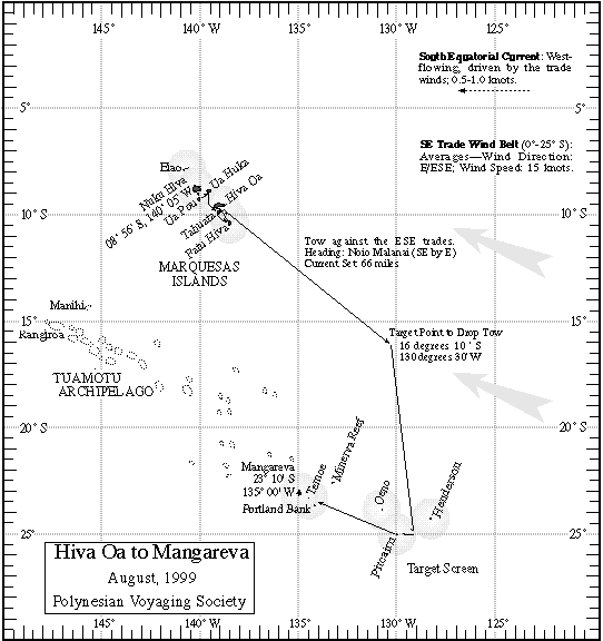
Navigators' Estimated Position at 6 pm, 08/18/99: 14 deg 25 m S, 15 miles N of the new reference course line. (Actual Position from GPS: 14 deg 28 m S, 131 deg 47 m W)
Navigators' Estimated Position at 6 am, 08/19/99: 14 deg 45 m S, 15 miles N of the new reference course line. (Actual Position from GPS: 14 deg 48 m S, 130 deg 42 m W)
NOTE: Since the reference course is from E to W the navigator is using N or S of the reference course line.
Est speed 4.5 knots (under tow); Actual speed is 6 kts.
Miles est. made in the last 24 hrs: 108 miles
Current Heading: 'Aina Malanai (ESE)
Strategy for Next 24 hrs: Chad plans to maintain course and speed, to be sure he is past 130deg W longitude, then at sunrise tomorrow Hokule'a will turn haka malanai (S by E) for Pitcairn, sailing hopefully, but under tow probably (due to light winds).
Winds- Hikina (E) at 8kts
Swells-Hikina (E), Manu Kona (SW), Manu Malanai (SE); flat, calm sea state
Cloud cover: only cumulus 10% cover
Weather prediction: Same--calm seas, wind from hikina @ 10kts or less
Steering: Hokule'a (arcturus, Hanaiakamalama (southern cross), hikianli'a (spica), jupiter, Ka heihei o na keiki (Orion)
Lat. stars: Shedir in Cassiopeia @ 18 deg on the meridian
Health of crew: Stomach flu still going around. Mel thinks it may be the water from Hiva Oa. The crew will start boiling all water today. The escort boat Kamahele has a water maker on board and has much excess water to supply Hokule'a.
No fish
Sightings: One booby
For more information on the leg to Mangareva,
go to the Hiva Oa to Mangareva Page.
For more information on the quest for Rapa Nui, go to the PVS Homepage.