Naked-Eye Astronomy and Navigation
Data for June 1999 to January,
2000
Last Updated: March 2, 1999
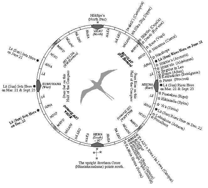
Directional Stars: Directional stars are called Hoku ho'okelewa'a: "Canoe-Guiding Stars." Any star can be used for direction, as long as the wayfinder knows the star's rising or setting point. A star rises, like the sun, in a particular direction on the eastern horizon, travels across the sky, and sets in a corresponding direction on the western horizon. The direction that a star sets in is at the same angular distance & in the same direction (i.e., north or south) from west as the house in which it rose is from east. Thus, the rising & setting points of stars are clues to directions. Recognizing a rising or setting star and knowing the direction it rises & sets in gives the observer a point by which to orient himself. The "declination of a star gives its rising and setting points in angular distance from east and west (0 degrees) at the Equator. As the observer moves away from the Equator, rising & setting points shift north for stars rising north of east; and south for stars rising south of east. Each night, at the equator, all the stars are visible, half the sky rising and half setting, except for the stars that are lost in the rising and setting sun. As the observer moves north of the equator, stars in the southern sky are lost, and stars in the northern sky become circumpolar; as the observer moves south of the equator, stars in the northern sky are lost, and stars in the southern sky become circumpolar. The Rising Points of the 21 Brightest Stars.
Planet and Star Data
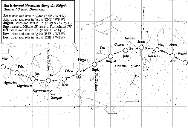
Sun: The sun is the main clue to direction, rising and setting each day in known directions. The rising and setting points shift during the year, from due east and west during Equinox (March and September, north of east and west in the summer, and south of east and west in the winter. During the voyage to Rapa Nui (June 15-January 1), the rising and setting points will be moving from 23.5 degrees north of east and west on June 21 (Summer Solstice); to due east and west on Sept. 23 (Fall Equinox); to 23.5 degrees south of east and west on December 22 (Winter Solstice). Movement of the sun along the Ecliptic (June-December.)
Latitude Stars: North of the equator, the altitude of the relatively fixed star Hokupa'a (Polaris, the North Star) is approximately equal to the latitude of the observer. At the equator (0 ° latitude), Hokupa'a is about at the horizon (0 ° altitude); at 10 ° N latitude, Hokupa'a is about 10 ° above the horizon; at 20 ° N latitude--the latitude of Hawai'i--it is about 20 ° above the horizon, and so on.
Stars crossing the meridian can also be used to estimate latitude. (The meridian is an imaginary line from due north to due south passing through the zenith, the point in the sky directly overhead; the meridian is perpendicular to the horizon; stars cross the meridian at the midpoint of their journeys from east to west.) At given latitudes, stars cross the meridian at specific altitudes. If the wayfinder knows the altitudes of stars crossing the meridian at particular latitudes, he can estimate his latitude by estimating the altitudes of these stars crossing the meridian.
The wayfinder uses pairs of stars that cross the meridian together to help him determine when stars are crossing the meridian. A line through two stars crossing the meridian together will be perpendicular to the horizon. The two stars are called a meridian pair. When the pair is upright, the stars are crossing the meridian together.
The altitude of the star can be measured using one's outstretched hand. (Each person's hand must be calibrated with distances [in degrees] in the sky; e.g., the height of the closed fist of an outstretched hand might be equal to 10 degrees of altitude on one person's hand, and 7° on another person's hand, depending on the size of one's fist.) Latitude Stars for Nukuhiva, Mangareva, Rapa Nui and Hawai'i.
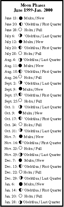
Moon: Like the sun, the moon travels along the path called the ecliptic; however, it completes it cycle in 29.5 days (not one year)--the time it takes for the moon to orbit the earth. As it travels along the ecliptic, the moon rises about 48 minutes later each night at a different postion on the eastern horizon from where it rose the night before. Its rising point moves back and forth between 'Aina Ko'olau (ENE) and 'Aina Malanai (ESE); its setting point back and forth between 'Aina Ho'olua (WNW) and 'Aina Kona (WSW). As it changes its position in relationship to the sun and earth, it goes through 29-30 phases (See "Moon Phases" below.) Determining the rising and setting points of the moon each night in relationship to another celestial body allows the moon to be used for navigation, day or night.
The line separating light and dark on the moon's surface is aligned approximately north and south since the moon is positioned east or west of the sun along the ecliptic.
Moon phases are an important factor in setting a departure date. Depatures are timed so that the moon is bright during certain segments of the voyage. A bright moon in the often cloudy ITCZ (around 3 degrees N to 9 degrees N) allows the wayfinder to see ocean swells at night when heavy cloud cover is hiding the canoe-guiding stars. Moonlight is also important when the wayfinder needs to determine latitude precisely, as in his approach to Nuku Hiva, Mangareva, Rapa Nui, and Hawai'i. The wayfinder will use the altitude of stars above the horizon to determine his latitude (see above); on cloudy nights with little or no moonlight, the horizon line cannot be seen clearly; moonlight renders the horizon visible. Moon Phases, June-December 1999