The Voyage to Rapa Nui / 1999-2000
Photo Below: Hokule'a sails east from Mangareva into the rising sun
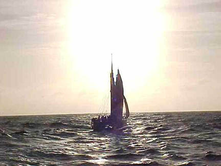 At dawn on October 8, 1999, crew member Max Yarawamai, a lookout posted at the bow of the voyaging canoe Hokule'a, sighted Rapa Nui (Easter Island)--a speck on the horizon, visible through a small hole in a wall of clouds. The canoe landed the next day, completing an amazing, improbable 19-day, 1,450-mile voyage from Mangareva to the most remote and isolated island in Polynesia. The twelve-member crew under navigators Nainoa Thompson, Chad Baybayan, and Bruce Blankenfeld had expected to sail against the wind for thirty-five days, navigating by celestial bodies and ocean swells and searching thousands of square miles of trackless ocean for a tiny island. Instead, blessed by favorable winds--a gift of their ancestors--they sailed directly east toward Rapa Nui for most of the way, and sighted the island on the first pass. Landfall at Rapa Nui brought closure to Hokule'a's twenty-five years of exploration and rediscovery of Polynesia which began in 1975, with the launching of the canoe at Hakipu'u-Kualoa in Kane'ohe Bay, O'ahu. Click here for thoughts of the three navigators--Nainoa Thompson, Bruce Blankenfeld, and Chad Baybayan--on finding Rapa Nui and reaching the third corner of the Polynesian Triangle. At dawn on October 8, 1999, crew member Max Yarawamai, a lookout posted at the bow of the voyaging canoe Hokule'a, sighted Rapa Nui (Easter Island)--a speck on the horizon, visible through a small hole in a wall of clouds. The canoe landed the next day, completing an amazing, improbable 19-day, 1,450-mile voyage from Mangareva to the most remote and isolated island in Polynesia. The twelve-member crew under navigators Nainoa Thompson, Chad Baybayan, and Bruce Blankenfeld had expected to sail against the wind for thirty-five days, navigating by celestial bodies and ocean swells and searching thousands of square miles of trackless ocean for a tiny island. Instead, blessed by favorable winds--a gift of their ancestors--they sailed directly east toward Rapa Nui for most of the way, and sighted the island on the first pass. Landfall at Rapa Nui brought closure to Hokule'a's twenty-five years of exploration and rediscovery of Polynesia which began in 1975, with the launching of the canoe at Hakipu'u-Kualoa in Kane'ohe Bay, O'ahu. Click here for thoughts of the three navigators--Nainoa Thompson, Bruce Blankenfeld, and Chad Baybayan--on finding Rapa Nui and reaching the third corner of the Polynesian Triangle.
 Sam Low: "Gift of the Wind: Aboard Hokule'a on Her Miraculous Voyage to Rapa Nui," with photos. This award-winning article first appeared in Hawaiian Airlines In-flight Magazine "Hana Hou," February/March 2000.) "Gift of the Wind: Aboard Hokule'a on Her Miraculous Voyage to Rapa Nui" (text only). Sam Low: "Gift of the Wind: Aboard Hokule'a on Her Miraculous Voyage to Rapa Nui," with photos. This award-winning article first appeared in Hawaiian Airlines In-flight Magazine "Hana Hou," February/March 2000.) "Gift of the Wind: Aboard Hokule'a on Her Miraculous Voyage to Rapa Nui" (text only).
Reports and Photos from the Voyage to Rapa Nui
Leg 1: Hawai'i to Nukuhiva (June 15-July 13, 1999)
Leg 2: Nukuhiva to Mangareva (July 31-August 29, 1999)
Leg 3: Mangareva to Rapa Nui (Sept. 15-Oct. 8, 1999)
Leg 4: Rapa Nui to Tahiti (Nov. 9-Dec. 3, 1999)
Leg 5: Tahiti to Hawai'i (Feb. 5-Feb. 27, 2000)
Maps: (1) the 1999-2000 voyage to Rapanui and back (color); (2) the 1999 voyage to Rapanui and back (black and white). (3) the 1999 voyage from Mangareva to Rapanui (color); (4) a map of the voyage from Mangareva to Rapa Nui (black and White; (5) another map of the 1999-2000 voyage from Hawai'i to Rapa Nui and back; (6) map of the Marquesas Interisland Leg: Nukuhiva, Ua Pou, Ua Huka, Tahuata, Fatu Hiva, and Hiva Oa.
Background on the Rapa Nui Expedition and Educational Projects
Sam Low: 1. "Rapa Nui: The Navel of the World"; 2. Log, Mangareva to Rapanui; 3. Log, Tahiti to Hawaii; 4. The Wake of Our Ancestors (on ecology and Hokule'a).
Ben Finney: "Voyaging and Isolation in Rapa Nui Prehistory"
|