
Closing the Triangle: A Quest for Rapa Nui
Polynesian Voyaging Society
History and Heritage
How to Track Hokule'a
The small maps in this packet can be used to track Hokule'a as it sails from Hawai'i to Rapa Nui and back from June 1999 to January 2000. A large wall map is also available.
Tracking the voyage can be an opportunity for learning more about the migrations of the Polynesians throughout the Pacific Ocean and the cultural connections among Pacific Islands. (See the Polylnesian Voyaging Society website at http://leahi.kcc.hawaii.edu/org/pvs for more information about Polynesian Migrations. The voyage is also an opportunity to learn more about the meteorology, oceanography, geography, and marine life of the Pacific Ocean. (For ideas on topics of exploration, see the Polynesian Voyaging Society website at http://leahi.kcc.hawaii.edu/org/pvs/rapanui/virtual.html.)
1. Plotting the Actual Position (Latitude and Longitude)
Latitude and longitude fixes will be posted each day on the Polynesian Voyaging Society / Bishop Museum / University of Hawai'i School of Ocean and Earth Science and Technology website (http://hokulea.soest.hawaii.edu). (The latitude and longitude reports will come from a sealed satellite transponder on board Hokule'a or a GPS unit on board the escort boat.)
To plot the latitude and longitude of the canoe:
1. Draw a horizontal line along the latitude given.
2. Draw a vertical line along the longitude given.
The position of the canoe is where these two lines intersect.
2. Plotting the Navigator's Estimated Position
Plotting the navigator's estimated position with the actual position of the canoe will highlight the difference between modern satellite navigation (pin-point accuracy at the push of a button) and wayfinding, or non-instrument navigation. Wayfinding is a less accuate, but more active process. Each day the navigators estimate Hokule'a's latitude from the altitudes of stars crossing the meridian around the north and south celestial poles (when these stars can be seen on clear nights) and from their memory of how far they have traveled and in what directions since their departure. They continuously adjust their estimates based on new clues in the environment. (For an explanation how the navigator uses stars for wayfinding and estimates latitude from stars, see Non-Instrument Navigation (http://leahi.kcc.hawaii.edu/org/pvs/navigate/navigate.html.)
On legs 1 (Hawai'i-Marquesas), 2 (Marquesas-Mangareva), 4 (Rapa Nui-Tahiti), and 5 (Tahiti-Hawai'i), the navigators will estimate their latitude and distance east or west of a reference course line (the lines with arrows on the map). The reference course line represents the most efficient route to a destination, given average winds and currents, the performance capabilities of the canoes, and the methods of non-instrument navigation. Course strategies and reference course lines for the five legs of the quest for Rapa Nui are on-line.
The navigators' estimated positions can be found in daily reports at http://leahi.kcc.hawaii.edu/org/pvs. The reports also contain information about wind and weather conditions, sailing strategy, and sealife (birds, fish and marine mammals encountered). Reports on previous legs can also
To plot the position of the canoe from the navigator's estimate:
1. Draw a horizontal line along the estimated latitude so that the line intersects the reference course line.
2. From the intersection of the two lines, use the scale on the bottom right corner of the map or the degree marking along the borders to measure out the number of miles east (to the right) or west (to the left) of the reference course.
The navigator has memorized the reference course line and will try to stay as close as possible to it. Hokule'a will not sail exactly on the course lines because wind direction and weather conditions will vary during the voyage, and clouds may prevent the navigator from seeing rising and setting celestial bodies, the most accurate guides to direction.
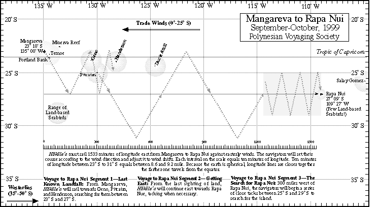
The voyage to Rapa Nui will be plotted differently. There is no reference course; the navigators will sail east toward Rapa Nui, estimating their latitude and their distance from Rapa Nui along the 27° South latitude line.
To reach its destination, Hokule'a will have to travel 1533 minutes of longitude eastward--from Mangareva at 135 ° W to Rapa Nui at 127 ° 27 minutes W. Because the earth is spherical, longitude lines get closer together the farther one travels from the equator. At the equator, one minute of longitude equals 1 nautical mile; at 27° latitude, one minute of longitude equals 0.89 nautical mile; so the voyagers will have to make 1364 nautical miles (1533 x 0.89) of easting at 27° S. The actual distance sailled may be much greater, as the canoe won't be traveling in a straight line. The voyagers will be tacking north and south against the prevailing easterly winds to get east, sailing directly east only when the winds shift to northerlies, southerlies, or westerlies.
3. Plotting the Canoe's Actual Course
The canoe's actual course may not be a straight line from the position in one report to the position in the next. During that time, the canoe may have tacked, or changed sailing directions, because of a change in wind direction, weather conditions, or sailing strategy.
When information is available about the sailing strategy and the direction, duration, and speed of the canoe during tacks, a plot of the actual course can be drawn, using the scale and the star compass on the map.
4. Practice Plotting the Canoe's Course
Students practice plotting Hokule'a's course using data from the first leg of the voyage, from Hawai'i to the Marquesas. Latitude and longitude fixes, navigators' estimates of position, and a description and analysis of leg 1 are included in this packet. Students compare and contrast, and discuss the differences between, the navigators' estimates and the actual positions and between non-instrument and instrument navigation. Students also discuss changes in the speed of the canoe (daily positions getting closer together or farther apart) and changes in direction of the canoe: what are causing these changes? Reading about the course strategy for reaching Nukuhiva from Hawai'i and daily reports on weather conditions and sailing strategy each day could provide students with answers.