 |
|
Closing the Triangle: A Quest for Rapa Nui Polynesian Voyaging Society (Updated: July 23, 1999)
I lunga (upwind) Directions to Rapa Nui, From June-October 1999, PVS is planning to culminate the last 25 years of voyaging--a generation of voyaging--with a voyage to Rapa Nui. Since Hokule'a was launched in 1975, it has touched every major island or island group in Polynesia except Rapa Nui. We sail to Rapa Nui to close the Polynesian Triangle, to make a connection with the far southeast corner of Polynesia and strengthen the bonds between the people of Hawai'i and Polynesia and the people of Rapa Nui, who are of one family. We sail to honor the people who found and settled Rapa Nui. Rapa Nui is the most isolated high island on Earth, and its discovery and settlement by Polynesian voyagers is one of the great accomplishments of exploration in human history. How did they find such a small island, over a thousand miles upwind of the nearest Polynesian settlement? We sail to honor our elders and küpuna and the many others who contributed to voyaging and its revival possible in the 20th century. We sail to train a younger generation of deep sea sailors and navigators to perpetuate Hawai'i's proud traditions of voyaging and navigation. We sail to explore our history and learn more about the history of Rapa Nui: By the time Europeans reached the island in the 18th century, it was practically treeless. No canoes. What happened to the trees? Because of the limited size of the island, perhaps the population outgrew the capacity of the island to support the people; or some natural disaster (e.g., a prolonged drought) may have caused the island environment to deteriorate beyond recovery. What lessons does the history of Rapa Nui have for Hawai'i and the planet earth?
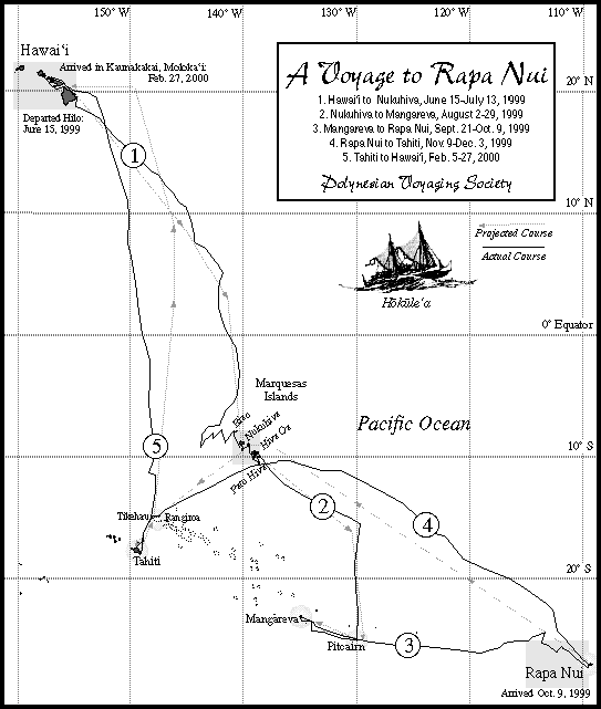
A Timeline and Itinerary (Updated: July 23, 1999) June 1999-January 2000: Voyage to Rapa Nui
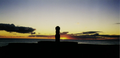
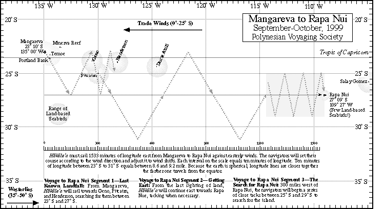
March 6, 2000: 25th Anniversary of the Launching of Hokule'a-- Celebration at Hakipu'u/Kualoa in Kane'ohe Bay The Challenge To get from Hawai'i to Rapa Nui, Hokule'a must travel to the 2820 nautical miles south (from 20 degrees N to 27 degrees S) and 2760 nautical miles east (from 155 degrees W to 109 degrees). The first three destinations (Nukuhiva, Mangareva, and Rapa Nui) lie upwind of the departure points, so the canoe will have to struggle to get east against the prevailing winds. The sail from Mangareva to Rapa Nui will be the most difficult, as Rapa Nui lies 1450 miles to the east of Mangareva. (See Sailing Strategies.) On this leg, Hokule'a will be navigated without instruments by a team of Hawai'i's best navigators, headed by Nainoa Thompson. They will guide the canoe by celestial bodies (sun, moon, planets, and stars), ocean swells, and land-based sea birds. Rapa Nui is a small, isolated island, making it a difficult target for the non-instrument navigator. Traditional non-instrument navigation, or wayfinding, cannot achieve the pinpoint accuracy of satellite navigation. The wayfinder sails into the vicinity of his destination and begins looking for the island. He may find an island close by and re-orient the canoe to his destination. The fact that many islands in the Pacific are part of island chains, with relatively closely-spaced islands made this sort of navigation practical in ancient times. However, there are no islands close to Rapa Nui. Pitcairn, the nearest inhabited island, is 1150 miles to the west. Furthermore, Rapa Nui is a small, low island, a triangle 13 x 11 x 10 miles, whose highest point is the 1674-foot Terevaka. To find this island, the wayfinders will have to sail within 46 miles of it, in clear weather, during daylight hours. (Formula for seeing objects at sea: Distance in Nautical Miles = Square Root of the Object's Height (in feet) + Square Root of Observer's Height (in feet; the height of the observer on the canoe, when the observer climbs the mast, is approximately 25 feet high). The wayfinders plan to use dead reckoning (estimating distance sailed, based on estimates of direction, speed, and time) and latitude stars (see below) to get within a couple hundred miles of Rapa Nui, then employ a zigzagging search pattern along the latitude of Rapa Nui (27 degrees S) to find the island. The zigzags in the pattern must be close enough together, so that the canoe will not sail past the island unseen just over the horizon. Wayfinders in the Pacific Ocean have traditionally used land-based seabirds flying home in the evening or flying from home in the mornings to fish. This clue to the direction of land expanded the target island, by a radius of up to 150 miles around the island. Once Rapa Nui had a thriving population of seabirds. In 1934-35, while conducting research on the island, Alfred Metraux reported gray, white, noddy, and gray-backed terns, as well as boobies, tropic birds, and frigates. Today Rapa Nui has few seabirds. A hawk introduced to the island to control the rat population has reduced the bird population. Thus, this landfinding technique is no longer available to the Hawaiian wayfinders. The quest to reach Rapa Nui will be made in the early spring of the Southern Hemisphere (September-October), when storms around Antarctica may break down the easterly trade winds and bring westerly winds. The wayfinders will observe the weather patterns that set up to figure out the best strategy for reaching the island. Starting on September 15, the crew on Mangareva will wait for favorable winds to launch. The voyage to Rapa Nui is the most challenging voyage undertaken by the Polynesian Voyaging Society; the results are uncertain. The probability that the wayfinders will find the island is not high. The highest priority is the safety of the crew. In searching for Rapa Nui, PVS will place a time limit on how long the crew will search for the island-around 40 days, after which limited food and water and fatigue may become safety issues. But whether the Hokule'a reaches Rapa Nui or not, we know that the early Polynesians did so. Beyond reaching the destination, what is important for the Polynesian Voyaging Society is to honor the great achievements of our Polynesian ancestors, to learn what we can about how they accomplished what they did, and pass on what we learn to future generations. Readings
|