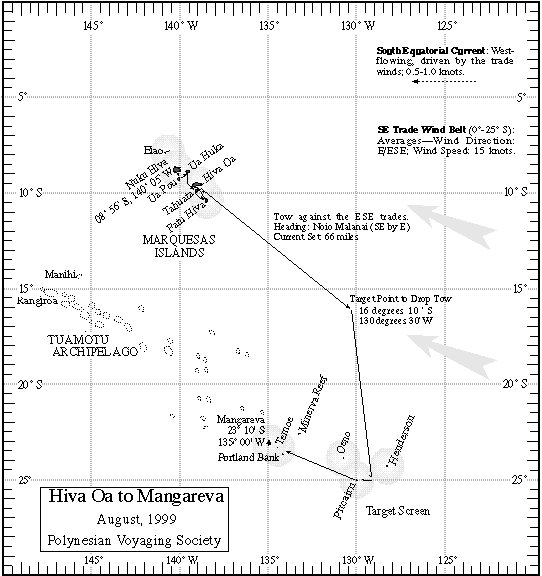
Hiva Oa to Mangareva
Report on 08/27/99, A.M.
Prepared by:Kamaki Worthington on Kamahele.
At 8pm HST Hokule'a departed Pitcairn Island for Mangareva.
Navigators' Estimated Position at 6 pm, 08/26/99: 24 deg 19 minutes S, 120 miles along the reference course line. (Actual Position from GPS: 24 deg 42 minutes S, 131 deg 59 minutes W)
Navigators' Estimated Position at 6 am, 08/27/99: 23 deg 55 minutes S, 120 miles along the reference course line. (Actual Position from GPS: 24 deg 22 minutes S, 132 deg 58 minutes W)
Navigators: Kathrine, Moana, Aldon
Heading: Last 24hrs, 'aina ho'olua @ 5kts (under tow)
Wind: Manu Ho'olua (NW) @ 15
Swells: Manu Ho'olua (NW) @ 4ft, (SW) Manu Kona 1ft
Clouds: cumulus, altocirrus, and cirrus
Changes: Wind switched from West to Northwest and increased in speed
Steering at night by: Na kuhikuhi (alpha/beta centuri), Hanaiakamalama (southern cross), Ke'oe (Vega), Humu ma (altair), ikaika (jupiter) and makulu (saturn)
Latitude stars: no stars were available for measuring latitude
Canoe and crew: All crew are 100% healthy, Hokule'a is also being constantly maintained at sea; hulls pumped, deck cleaned, canvas repaired.
Fishing Report: No fish......again
Crew Quote: Today, we spoke with a crew member from Lana'i, Gary Suzuki.Photo of Gary S. Driving the Dingy. Gary is one of the hardest working crew members on Hokule'a. He's always helping others and has a lot of energy; "To be on Hokule'a for me is an honor. I feel I'm very lucky to be here, so I try to do my very best. Hokule'a sails for all Hawai'i Nei".
For more information on the leg to Mangareva, go to the Hiva Oa to Mangareva Page.
For more information on the quest for Rapa Nui, go to the PVS Homepage.