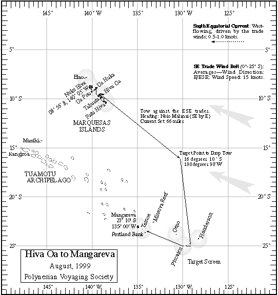
Hiva Oa to Mangareva
Report on 08/22/99, A.M.
Navigators' Estimated Position at 6 pm, 08/21/99: 19deg 30 minutes S, 30 miles W of the reference course line. (GPS: 19 deg 40 minutes S, 130 deg 9 minutes W)
Navigators' Estimated Position at 6 am, 08/22/99: 20 deg 30 minutes S, 30 miles W of the reference course line. (GPS: 20 deg 36 minutes S, 130 deg 7 minutes W)
Heading last 24hrs: Haka Malanai (S by E) @ 5kts (under tow)
Miles in last 24 hrs: 120
Strategy: Maintain course and speed, begin looking for expanded landfall signs: i.e., land birds, ocean debris.
Winds: Haka Malanai @ 7kts
Swells: Hema (South) @6-8 ft, Nalani [Malanai? SE by S] @ 6-8ft
Clouds: cumulus, alto stratus, and cumulostratos @ 60%
Changes in last 24 hrs: Wind switched and decreased from south to 2 houses east of south (SSE). Chad thinks high pressure is settling into our region and easterly trade winds will set in.
Next 24 hrs: Chad feels the wind will continue to decrease to 10 kts, and slowly change direction, from SE to E, as the trade winds set in.
Steering at night by Puana (Procyon), A'a (Sirius), Hoku'ula (Mars), Ikaika (Jupiter); Not too many stars were visible as cloud cover was at 90%
Latitude star: Poloahilani (Shedir) in Iwakeli'i (Cassiopeia) @ 13 degrees above the horizon at the meridan.
Birds: Koa'e kea (white-tailed tropic bird)
Crew status: Finally, after solving the stomach flu problem, all crew are 100%. They spent the majority of the day cleaning out all the sleeping compartments. At the end of the day, they crew performed a play of sorts. The first dance was about hunting a pig, the second dance was about the demi-god Maui (affectionately played by Mona Shintani).
Sources of Information: Moana Doi, Cat Fuller and Chad Baybayan.
Prepared by: Nalani Wilson on Hokule'a; Kamaki Worthington on Kamahele.
For more information on the leg to Mangareva,
go to the Hiva Oa to Mangareva Page.
For more information on the quest for Rapa Nui, go to the PVS Homepage.