 Tracking
Information: Nukuhiva to Hawai'i
Tracking
Information: Nukuhiva to Hawai'i

1995 Voyage of Hokule'a/Hawai'iloa/Makali'i
To reach Hawai'i from Nukuhiva, Hokule'a and Hawai'iloa will round the western side of
Nukuhiva
and sail
north in the SE Tradewinds to 3 deg. N latitude; travel as quickly as possible on a N by W course across an area of
light, fickle winds, dead calms, and heavy cloud cover from 3 deg. N to 9 deg. N latitude; then head NWW to 20.5
deg. N, the mid-latitude of the Hawaiian Archipelago.
The navigators hope to arrive somewhere upwind, or east, of Hawai'i. After determining their latitude to be 20.5
deg. N, they will turn due west and begin looking for an island in the
240-mile wide screen of islands from 18.5
deg. N (60 miles south of Ka Lae, or South Point, on the Big Island) to 22.5
deg. N (40 miles north of Ha'ena, Kaua'i).
The navigators will look for Mauna Kea on the Big Island, over 2 miles high. This mountain can be seen from over
100 miles away in clear weather. However, vog (volcanic haze) from the current Kilauea eruption could obscure
Mauna Kea.
The navigators will be guiding the canoes without instruments, using
celestial bodies, the wind and the ocean
swells for direction. Each morning they will give their estimated positions via radio.
The estimated latitudes will be based on the estimates of distance traveled in a northerly direction and on hand-
measurements of the altitude of Hokupa'a (the North Star) and Hanaiakamalama (Southern Cross) and other stars
crossing the meridian close to the horizon.
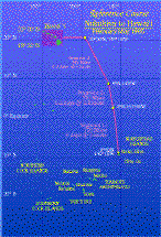 A reference course
will serve as a local zero degree longitude line. The navigators will estimate their distances in
miles east or west of this reference course at theft estimated latitudes. To plot the estimates of miles east or west of
the reference course at the estimated latitudes, a map with latitude markings and the reference course will be
needed. (See the attached
map.)
A reference course
will serve as a local zero degree longitude line. The navigators will estimate their distances in
miles east or west of this reference course at theft estimated latitudes. To plot the estimates of miles east or west of
the reference course at the estimated latitudes, a map with latitude markings and the reference course will be
needed. (See the attached
map.)
The navigators will use the altitudes of stars in the upright Hanaiakamalama (Southem Cross) to determine when
the canoes are at 20.5 deg. N. During the first week of May, 1995, when the canoes expect to reach the mid-
latitude of Hawai'i, Hanaiakamaiama will rise at sunset and cross the meridian in an upright position around 9:20
p.m. During this transit, the cross will point due. The distance from the horizon to the bottom star of the cross (Ka
Mole Honua, or Acrux) will be about equal (6 deg. 24' above the horizon) to the distance from the bottom star to
the top star (Kaulia, or Gacrux), which will appear at about 12 deg. 23' above the horizon).
![[Home Page]](../pics/homepage.gif)
![[Back One]](../pics/backone.gif)