
Nihoa and Mokumanamana
Dennis Kawaharada
(from Storied Landscapes, 1999; rev. 2010)
In 1822, Ka`ahumanu and a royal party including Kaumuali`i, Liholiho, Keopuokalani, and Kahekili Ke`eaumoku visited Ni`ihau and heard chants and stories about an island called Nihoa to the west of Kaua`i, the direction from which the winter rains came:
`Ea mai ana ke ao ua o Kona,
`Ea mai ana ma Nihoa
Ma ka mole mai o Lehua
Ua iho a pulu ke kahakai
The rain clouds of Kona come,
Approaching from Nihoa,
From the base of Lehua,
Pouring down, drenching the coast.
Intrigued, Ka`ahumanu organized an expedition and sailed in two or three boats under Captain William Sumner to visit the island. They landed on the once inhabited but long deserted island 150 miles WNW of Kaua`i, and annexed it to the Hawaiian Kingdom. The waterfront area around
Ka`ahumanu Street in Honolulu was named Nihoa in honor of the visit. The island was annexed to the Hawaiian Kingdom again by Kamehameha IV, who landed on the island in 1857. In 1885, Queen Lili`uokalani, with 200 excursionists, visited Nihoa on the steamer `Iwalani, and brought back artifacts—a stone bowl, a stone dish, a coral rubbing stone, and a coral file (Emory 8-11).
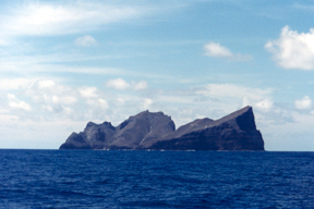
Nihoa, jutting up from the sea beyond sight of Kaua`i and Ni`ihau, is the westernmost place in this tradition of Kaua`i geography. It has come to stand for “one who bravely faces misfortune”:
Ku paku ka pali o Nihoa i ka makani. The cliffs of Nihoa stand strongly against the wind (Pukui, `Olelo No`eau #1924).
“Nihoa” means “firmly set,” or “toothed, serrated,” possibly a reference to its jagged profile—from one side it looks like a molar, standing isolated at sea.
(In Micronesia, an island seen from a departing canoe just before the island disappears from sight is called a “tooth,” and serves as a final landmark to orient the canoe on its voyage.)
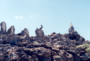
Nihoa is one mile long, a quarter of a mile wide, and 900 feet high on its east end. It was designated as part of a wildlife refuge by Theodore Roosevelt in 1909. It is inhabited by insects; monk seals; two species of land birds, a finch and a millerbird, found nowhere else; and numerous seabirds (terns, boobies, petrels, shearwaters, albatrosses, tropic birds, and frigate birds). Today, access is controlled by the U.S. Fish and Wildlife Service, and landing, except for scientifi c study and cultural purposes, is prohibited.
Nihoa was once inhabited by the kanaka maoli, sometime between 1000 and 1500 A.D. About 35 house sites, 15 bluff shelters, 15 heiau, and 28 agricultural terraces have been identified on the island (Emory 12; Cleghorn 21-22).
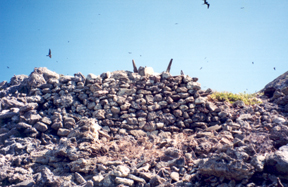
Various artifacts have also been collected, including fi shhooks, sinkers, cowry shell lures, hammerstones, grindstones, adzes, and coral rubbing stones (Emory 38-50). The evidence seems to indicate permanent or semi-permanent settlement. Living on the island would have been difficult. Surveys have discovered only three seeps of water, all contaminated with guano (Emory 12). Tava and Keale report a tradition of Ni`ihau that a spring called Waiakanohoaka provided good, sweet water (102), but this spring has not been located. The freshwater on the island comes from the estimated 20-30 inches of rain that falls annually from passing squalls (Cleghorn 26).
Archaeologists surmise that the terraces were planted with sweet potatoes, a crop requiring less water than thirsty taro. They estimate that the 12-16 acres under cultivation might have supported about 100 people (Cleghorn 25). Fish, shellfi sh, crabs, lobsters, turtles, and seals, as well as seabirds and their eggs, are abundant sources of food. Cleghorn speculates that the food and water supply was suffi cient for subsistence, but that the lack of fi rewood would have created a hardship (26). The only tree on the island is the loulu palm. Research expedition members counted 515 palms in 1923. The fan-like leaves were used for plaiting, and the trunks could have been used for building shelters or for fi rewood. But if the trees were cut down for firewood, the supply would have eventually been depleted.
Without the numerous kinds of plants found in the forests of the larger islands (e.g., koa, `ohi`a, hau, hala, olona, wauke), the settlers could not have provided themselves with canoes, wood containers, nets, fi shing line, clothing and blankets, mats, and medicines. The colony was probably supplied with these products from Kaua`i or Ni`ihau. Several gourd fragments have been found; other bowls and containers were carved from stone.
Landing on the island is difficult. High, sheer cliffs prevent landing on the east, north, and west sides. The island slopes down to the south, but the shoreline is rocky and unprotected from the surge of southerly swells. Large vessels anchor off shore, and those who wish to land have to go in on a smaller boat or swim ashore. In ancient times, small canoes could have been carried up onto the rocky coast on calm days. If the canoes used to reach the island were somehow damaged in the rough surf, the settlers would not have been able to repair them with resources from the island. They would have been trapped until other canoes arrived from Ni`ihau or Kaua`i.
Partial skeletons of men, women, and children have been found on the island, and two burial sites located. The journey of spirits to the afterworld (in the west, toward the setting sun) would have been shorter from this western outpost than from the islands to the east. The name of a place on the island where spirits of the dead departed for the afterworld is still remembered: It was called Mau-loku (“Continuous falling”; Pukui et al, Place Names of Hawai`i).
How the island was discovered is not known—possibly by fisherman working the seas west of Kaua`i or following seabirds to gather their feathers or eggs. Red feathers were coveted for making sacred objects, and the red-tailed tropicbird is one of the seabirds that nests on Nihoa. Polynesians traveled great distances to obtain such feathers: One Marquesan tradition tells of a 1200-mile voyage, from Hiva Oa to Rarotonga, to obtain the red feathers of a kura bird; and the voyaging chief Hema is said to have sailed back to Kahiki to obtain a girdle of red feathers for his son Kaha`i.
Once discovered, the island became a part of the economy of Ni`ihau, an island relatively limited in resources. The traditions of Ni`ihau say that the people of that island were frequent and perhaps long-term visitors to collect loulu palm wood for spears and a grass called makiukiu, which could be used for cordage and stuffing (Tava and Keale 102).
Another motive for visiting the island is suggested by the chant of Ni`ihau describing the Kona rain clouds coming from Nihoa and soaking the west coasts of Kaua`i and N`ihau. Small, low islands like Ni`ihau, and the leeward coasts of high islands like Kaua`i, depend on the heavy rains of annual Kona storms to bring life to their crops. But if the storms stay west or pass to the north without reaching Hawai`i, droughts and, in ancient times, famine could occur. Could the people of Ni`ihau or leeward Kaua`i have sailed west to get closer to the source of these rain clouds, or to the deities who controlled them, in order to pray for rain and make offerings? Water represented life and wealth in ancient Hawai`i, and such a voyage might have been worth the effort and the risk.
One hundred and fifty miles west of Nihoa is Mokumanamana (Necker). This island is smaller and has even fewer resources than Nihoa.
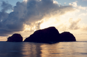
There are no trees and is no soil. Yet the island is covered with some 33 heiau (Emory 59).
Several stone images, the largest around 16 inches high, were found by visitors in historical times. The images look like gingerbread men—flat, neckless, with round faces from which eyes, noses, mouths, and ears protrude (Emory 125, Illustrations XX-XXII). Who or what these images represent is unknown.
Teva reports that there are four names remembered on Ni`ihau of islands beyond Nihoa: Mokuakamohoali`i, Hanakaieie, Hanakeaumoe, and Ununui (103). Mokuakamohoali`i, “Island of the Shark God Kamohoali`i,” is another possible name for Mokumanaman: the largest geographical feature on this island is a bay called Shark Bay. Kamohoali`i was the king of sharks and brother of the volcano goddess Pele. The Pele migration is said to have come from the west, with Kamohoali`i serving as navigator.
Cleghorn suggests that in addition to going to Mokumanamana for gathering resources such as bird feathers and eggs, the visits may have had a ritualistic purpose: The heiau could have belonged to a bird cult, similar to the one on Rapa Nui (Easter Island) (61). But the heiau and statues could also have been used in rain-god worship. As in the Hopi kachina rituals in the American Southwest, the rain deities might have been associated with ancestral spirits who return each year in the form of rain clouds from their homes in the west. (The winter rains of the American Southwest come from the west, as they do in Hawai`i.) In either case, birds and rain clouds are metaphorically connected with each other in Hawaiian chants. Beckwith notes, “The cloud hanging over Ka`ula is a bird which flies before the wind”:
The blackbird begged,
The bird of Ka`ula begged,
Floating up there above Wa`ahila
(The Hawaiian Romance of Laieikawai, 323)
Nihoa would have been a stop on the way to or from Mokumanamana. Annual visits to Mokumanamana during the spring and summer trade wind season could have been made, when food would have been abundant on and around Nihoa and Mokumanamana. A Ni`ihau tradition suggests such was the case: “The Ni`ihauans sailed to Nihoa in the spring, returning to Ni`ihau in the fall on the Kona winds” (Tava and Keale 102). The same sailing strategy could have taken them to Mokumanamana. After landing on the island, prayers and offerings could have been presented to the deities. Then the pilgrims could have fished, hunted birds, collected eggs, and built or maintained heiau. When a cold front approached, the canoes could have headed back to Ni`ihau or Kaua`i on the southwesterly winds that preceded the front, or the northerly winds that followed.
Any downwind sail with the prevailing winds is a risky undertaking, because unless the wind shifts, the sail home involves tacking into the wind, something which the keel-less Polynesian canoes would have great difficulty doing. The risk is weighed against the importance of the potential benefi ts of going to the downwind destination. For a community dependent on farming, drought could be disastrous. If one of the sources of the life-giving waters of Kane was westward, was it worthwhile to sail west to present offerings and prayers to a god who brought life-giving waters? For a time in Hawaiian prehistory, the answer was apparently yes; then, perhaps after dry-land taro and sweet potato cultivation in areas with limited rainfall had improved enough so that famine was no longer a seasonal threat, such voyages became unnecessary.
Works Cited
Beckwith, M. W. (1919). The Hawaiian Romance of Laieikawai. Translation of Laieikawai by S.N. Hale`ole. Washington D.C.: Government Printing Office, 1919. pp. 285-666.
Cleghorn, P. (1987). Prehistoric Cultural Resources and Management Plan for Nihoa and Necker Island, Hawai’i. Honolulu, HI: Bishop Museum.
Emerson, N.B. (1965). Unwritten Literature of Hawai`i: The Sacred Songs of the Hula. (First published in 1909 by Bureau of American Ethnology) Rutland, Vermont: Charles E. Tuttle Co., Inc.
Emory, K. P. (1928). Archaeology of Nihoa and Necker Islands. Honolulu, HI: Bishop Museum.
Tava, R. & Keale, M.K. Ni’ihau: The Traditions of an Hawaiian Island. Honolulu, HI: Mutual Publishing.
Pukui, M. K. (1983). `O lelo No`eau: Hawaiian Proverbs & Poetical Sayings. Honolulu, HI: Bishop Museum Press.
Pukui, M. K. (1984). Place Names of Hawai`i (seconed edition). Honolulu, HI: University of Hawai`i Press.