 |
|
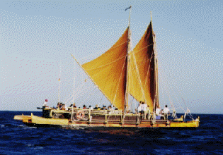
Spring 1995: Na 'Ohana Holo Moana Photo right: The Hawaiian Voyaging Canoe Hawai'iloa February 13, 11:30 a.m.
The north wind has shifted to the south as a Kona storms approaches. Winds are southerly at 15 knots. Seas 8-12 feet. The canoe is heading in a southeasterly direction at 3-4 knots. The weather has been good. Sailmaster Nainoa Thompson aboard Hokule'a expects the NE trades to return once the Kona storm moves east of the canoes. Hawai'iloa and Hokule'a have been sailing together since leaving Hilo. Hawaii'iloa is in sight 2 miles west of Hokule'a. Sailmaster Chad Baybayan of the Hawai'iloa says that the new canoe is sailing well and taking on very little water in spite of its ope n hulls. The first two nights were clear and cold due to the north winds, making navigation by the stars easy. The canoes are steering by a large N swell during the day. This swell is slowly diminishing. Hawai'iloa has had better luck at fishing than Hokule'a. Fisherman Terry Hee caught an 80 pound ahi yesterday and a small mahimahi around lunch today. Yesterday, crew member Richard Konn on board Hawai'iloa's escort boat Kama Hele was injured while cutting up a fish the escort boat had caught. While the injury was not serious, he was medivaced off the boat by the Coast Guard since the crew did not want to risk infection of the wound on the 4 week voyage to Tahiti. The crews of the canoe will try to call two classrooms in Hawai'i a day to share their experiences with students. The first call today went to students of Ka Papa Honua o Keawanui, a Kamehameha Schools Alternative Education program at Moloka'i High School . The students had put on board Hokule'a a gourd containing three taro corms and three pia (arrowroot) tubers, protected by wet moss. Crew member Shantell Ching reported that the taro was sprouting and doing well. The students asked if they could send any thing to the crew once the crew reached Tahiti. Sailmaster Nainoa Thompson answered "Dried bananas. Can the students dry bananas from their farm to help provision Hawai'iloa on the way home?" Crew members want to try a traditional Polynesian diet on the w ay back to Hawai'i from Nukuhiva in the Marquesas Islands, explained Thompson. "How much?" the students asked. "Enough to feed a crew of eleven for about twenty days. I know that's asking a lot. Do what you can . . . " February 14, 1:45 p.m. Satellite Reading (8:09 a.m.): 18 degrees 44' N,152 degrees 16' W. Navigators on board Hawai'iloa estimated the canoes to be at 18 degrees 30'N, 138 miles E of their reference course. Winds were from the S to SE at 10-12 miles per hour, and the canoes were sailing east at about 3-5 knots, waiting for the winds to shift s o they could take a more southerly tack. The canoe was about 170 miles E by S of Cape Kumukahi. The skies were sunny. Hokule'a was out ahead of Hawai'iloa. How far back was Hawai'iloa? "Way back," said Nainoa Thompson on board Hokule'a. "We're doing 5 knots and they're doing 2." (Laughs, with the rest of the Hokule'a crew.) Scott Sullivan, radio man on board Hawai'iloa: "We'll see who gets to Tahtiti first!" Earlier navigator Chad Baybayan explained: Hokule'a sails better than Hawai'iloa closed hauled to the wind [as the canoes were this morning, and as the/ canoes will be for most of the way to Tahiti]. Hokule'a points higher into the wind [without losing as much speed]. Hawai'iloa is faster sailing off the wind--it's lighter and faster off the wind. "We should do better on the way back from the Marquesas [to Hawai'i, when the canoes will be sailing with the wind coming from behind the canoe rather than in f ront of it.] On the different feel of the two canoes: Chad says Hawai'iloa has a silkier feel, a smoother ride. It doesn't plow into the waves as Hokuel'a does, but glides over them, because of its rounder hulls (which is also why it doesn't sail as well into the wind , or close-hauled). The older Hokule'a also creaks more; the lashings are tighter on the newer Hawai'iloa. However, the crew has been hearing a strange noise coming from somewhere on the canoe. Chad wondered if a cat had snuck on board. February 14, 4 a.m. Satellite readings for 2/13, A.M.: 18 degrees 44' N, 153 39' W. Satellite readings should be available daily after 9 a.m. HST, depending on avaiability of a person to fax them out. The designated person was not able to figure out how to fax the informatio n from the computer yesterday morning. Regarding slow progress for the first two days (only 80 miles!). The canoes lost time while waiting for the Coast Guard to medivac injured crew member from the escort boat KamaHele (See 1/13 report.) Progress should be better yesterday and today. At 3-4 knots (yesterday's estimated speed),the canoes will sail 75-100 miles per day. With stronger winds, the canoes will sail 5 or more knots (max speed: 10-12 knots), or about 120 or more miles per day (ma x about 200 miles per day). Two of the three escort boats have a max speed of 7-8 knots. The canoes at times will have to slow down (drop their sails) to allow the escort boats to catch up. February 15, 7:45 p.m. Hokule'a and Hawai'iloa were no longer in sight of each other this morning. Satellite readings (around 8 a.m.): Hokule'a: 18 degrees 17'N; 150 degrees 46' W (ARGOS) Hawai'iloa (Navigators McKenney/Omai): 18 degrees 7' N; 197 miles E of reference course. Hawai'iloa is 20-30 miles NE of Hokule'a. Hokule'a (1 p.m.): 18 degrees 4' N, 150 degrees 52 minutes W (GPS). The canoe has moved around 13 or 14 miles in 5 hours, average speed a little less than three knots. A rainy morning at sea. After three days of clear skies, high cirrus clouds hid the sky most of the night, only a few stars visible. The navigators steered by Hokupa'a (Polaris), almost stationary due north, and Hanaiakamalama (Southern Cross), which poin ts due south as it stands upright crossing the meridian at about 3:12 a.m. in the morning. The Kona storm which was over O'ahu on Monday and Tuesday moved east over the canoes. The rain was cold, but welcomed, allowing crew members take their first freshw ater bath since leaving Hilo. The winds were light and variable, 5-10 knots out of the NW at the time of the morning radio call. The canoes were sailing south slowly, at 3-4 knots. The National Weather Service predicted the winds would gradually clock W, then S and remain S to Southwe sterly until at least till Sunday. Not good news. The canoes will be prevented from making much progress toward Tahiti. In strong trades, the canoes could reach 9 degrees north, the northern edge of the area of doldrums (Intertropical Convergence Zone, or ITCZ),to complete the first segment of their voyage to Tahiti in about a week. Now with the southerly winds, it will take them much longer. Having lost a day due to the rescue of the injured crew member on Sunday now has more significance. Looking for wind: According to the National Weather Service, the NE trade winds are blowing between 10-15 degrees N at the longitude of the canoes (150 degrees W), a couple of hundred miles to the south. Another Kona storm is due in on Saturday, which may prevent the trades from reaching the canoe for an even longer time. This is the first time the canoes have left for Tahiti so early in the year, during the northern hemisphere winter. Kona storms, typical at this time of the year, are disrupting the flow of the NE trade winds. (Earliest departure date: March 15, 1980, Nai noa's first voyage as navigator; Latest departure date: July 10, 1985, on the Voyage of Rediscovery). Steering by the swells: After a large N swell diminished a couple of days ago, the swell pattern became confused, small swells from various directions due to the disruption of the trade wind pattern, the kona storm, the variable wind direction. The patter ns were gradually reforming this morning. Nainoa said he was reading three swells-- One from the north (created by the storm center north of Hawai'i, one from the NE (from the NE trades still blowing far to the NE of the canoe) and one from the SE (from t he SE trades, blowing below the equator.) According to Ka'au McKenney, the SE swell was the most distinct and he was using it to steer by. Fishing: So far, small fish for Hokule'a: 2 aku, one eaten for breakfast; 2 mahimahi. Hawai'iloa: one 60 lb. ahi; 1 small mahi, 1 small aku. Call placed to Kamehameha Schools: Monica Kaiwi's Pacific Literature Class--Student Nova asked about the awapuhi capsules placed on board to test the effectiveness of this traditional remedy for seasickness. Some crew members are taking the capsules. Acco rding to Nainoa, no one has gotten sea sick yet. The seas are fairly calm, so the remedy has not been truly tested. Call placed to Wai'anae: Susan Lum's Marine Science Class: This class placed some live manauea (called ogo in Japanese), an edible seaweed, on board Hawai'iloa to see if would survive the 30-day trip. The class produces and markets manauea as part of an a quaculture project. Brad Cooper reported the seaweed was not doing too well. "Is it turning white?" asked Susan in kind of a panic. "Yes, it's turning white." "Are you changing the water in the bucket twice a day?" "Yes we're changing it twice a day." "Ma ybe you should change it more often." "Okay, we'll change it more often." "Is the water too warm? Are the tips of the seaweed out of the water? Is the bucket exposed to the sun and wind?" "The water is seawater. . . The tips are submerged . . . The bucket is in a partially shaded area." "Maybe there's too much in the bucket, can you take some out and eat it?" "Okay, we'll eat some." Brad, a teacher at Kamehameha Schools said the voyage is a dream come true for him. He has been teaching about voyaging and migration for years. Now he is actually participating in a voyage. Susan asked to contact Hokule'a to find out if the crew had eaten the dried manauea her students had put on board. Mike Tongg confessed they hadn't. "You should eat it. You need to soak it in water first. I put some recipes on board." "Okay, we'll try it and report back next week." Scott, on board Hawai'iloa: "We ate some of ours. We used to it make ahi poke [raw chunks of tuna mixed with seaweed, soy sauce, and other condiments that might be available]!" February 16, 5:30 p.m. Winds shifted to the east at midnight last night, an advantageous direction for the canoes, as it allowed them to head south (heading haka malanai, or S by E; with the current set factored in, they are sailing almost due south). Wind speed was 10-15 knots , and the canoes were going at 5-6 knots. A scattering of cumulus clouds suggested fair weather and the possibility that the trades were returning. The canoes were sailing off the the wind, both crews were expecting Hawai'iloa to catch up with Hokule'a. They were on the lookout for each other, but hadn't caught sight of each other as of the morning report. Hawai'iloa was about 33 miles W of Hokule'a at about the same latitude. Satellite readings (about 9 a.m.) Hokule'a: 17 degrees 17' N; 150 degrees 59' W (ARGOS) Navigators' Estimate (Ka'au/Keahi on Hokule'a): 17 degrees 6' N; 187 miles E of the reference course. Hokule'a (about 3 p.m.):16 degrees 37 minutes N;150 degrees 55' W.(GPS) The canoes have travelled about 100 miles due south over the last 24 hours. If they can reach 15 degrees N (about 100 miles to go) before Saturday, they can escape the southeasterly winds associated with a Kona storm that is expected to reach Hawai'i by S aturday, and find the NE trade winds they have been looking for since leaving Hilo. Navigation: The SE swell remains the most distinct, the easiest to steer by. The night was cloudy, making navigation difficult, but the navigators were able to steer at times by Hokupa'a (North Star), keeping it directly astern as they headed south. The f ull moon was also an aid to navigation, rising five degrees north of E around sunset, and setting around 3 degrees north of W around sunrise. The bright planet Jupiter was also used as it rose ESE after midnight near Lehuakona (Antares) in the constellati on of Manaiakalani (Maui's Fishhook, or Scorpio). Just as Hokule'a called Hilo High School (Milly Kaneshiro's class) at 9 a.m., Scott Sullivan reported catching a 10 pound mahimahi. Keahi joked,"Too small, that's the one we threw back!" Brad Cooper reported to his 7th graders at Kamehameha Schools the only sea life so far has been a couple of booby birds, one which attempted to land on the mast, and something in the ocean that may have been a pilot whale. February 17, 6:30 p.m. Favorable easterly winds, at 15-18 knots, continued today for Hokule'a and Hawai'loa. The canoes were moving at about 5-6 knots. Navigators Baybayan and Blankenfeld on Hawai'iloa estimated their position 14 degrees 25' N, 78 miles east of their reference course. Their actual position at about 7 a.m. this morning was 15 degrees 33'N, 151 degress 8' W (ARGOS), about 60 miles farther north than their estimate. Hokulea's was farther south and to the east at 15 degrees 15' N, and 150 degrees 46' W. The two canoes are sailing south on almost parallel courses, making about 120 miles a day. Skies were patchy with clouds last night. The navigators used Hokupa'a (North Star), Hokule'a (Arcturus) rising ENE in the evening, and the red planet Mars, near Regulus, in Leo, rising ENE after sunset and setting WNW in the early morning. The SE swell c ontinued to dominate. According to the National Weather Service, the canoes had sailed out of the area of southerly winds and should have easterly winds and fair sailing weather down through the area of doldrums and into the southern hemisphere. A high pressure ridge south of Hawaii has moved the trade winds farther south than usual. Thunderstorms between 4-5 degrees N and 152-158 W should not affect the canoes as they cross the Intertropical Convergence Zone. Hawaiiloa is sailing comfortably, taking on very little water in its open hulls. The crew reported pumping about 2 gallons per hour. The nights are getting warmer as the canoe moves away from the north winds and gets closer to the equator. The two canoes will not try to find each other at this point, but to make as much distance as they can toward their southern destination in the favorable winds. When the winds lighten toward the equator, they may try to find each other and sail together a gain. An historic event took place this morning: For the first time, a radio report was done in Hawaiian from a voyaging canoe. Crewmembers Reggie Keaunui and Dennis Chun of Hawai'iloa spoke with Kanoe Naone's 7-8th grade class at the Waiau Immersion School on O'ahu for about 30 minutes. They discussed, among other things, navigation, sailing conditions, sea life, and life on the canoe. Navigator Blankenfeld reported that the crew was seeing very little life on the open ocean: an 'ake'ake (petrel) and lone 'a (boobies). February 18, 4:45 p.m. Hokule'a and Hawai'iloa continued to make good progress south in brisk tradewinds. The canoes are heading on a course SSE, with the current setting the canoes on a little more southerly course (S by E). At the time of the morning report, the canoes were s ailing about 5 knots. Two hours later they picked up speed, doing about 7 knots. At these speeds the canoes would make between 120-168 miles per day, and the canoes will reach the northern edge of the area of doldurms (about 9 degrees north) in about two days. With sunny weather this morning, the crew of Hokule'a dried out their clothes and did their laundry. The crew cuaght an ono and a mahimahi today; yesterday, they caught two ono and two mahimahi. After rain squalls in the evening, the sky cleared and the navigators had a full sky of stars to steer by. Hokule'a navigator Keahi Omai estimated the canoe to be at 13 degrees 46' north, and 75 miles east of their reference course. The actual position of the canoe (6:45 a.m.) was 13 degrees 15' N and 150 degrees 15' W, or about 96 miles east of their reference course. The Hawai'iloa was about 50 miles NW of Hokule'a at 13 degrees 46' N and 150 degrees 47' W, still behind and farther to the west. Both canoes are losing the easting (the miles east) that they gained from their reference course at the start of the voyage a week ago. The canoes will have to hold onto some of that easting in order to arrive upwind of Tahiti. |
 Navigators on the Hawai'iloa estimate the canoe to be at 18 degrees 40 minutes N, and 30 miles east of their reference course. This would place them about 80 miles SE of Cape Kumukahi on the Big Island. (The starting point of the canoes' reference course. )